Chaulden

Chaulden
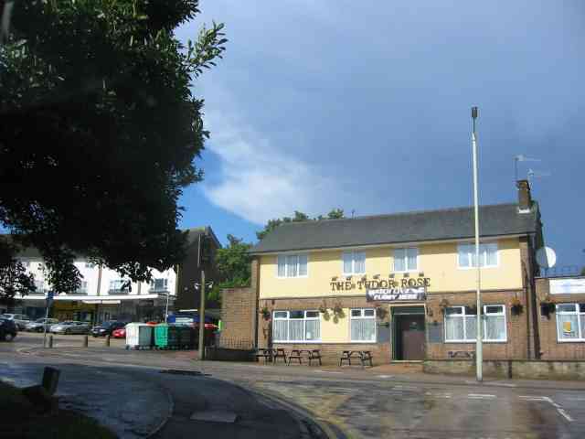
The Tudor Rose pub, built in 1957 adjacent to the Chaulden Neighbourhood centre parade of shops.

Chaulden is a residential district in Hemel Hempstead , Hertfordshire, England located west of the town centre and bordering on open countryside. It was an early development in the construction of Hemel Hempstead new town , commenced in 1953 and has its own neighbourhood shopping centre.

The name Chaulden can be traced back to 1523 as a local field name and means a chalky valley. A country house and estate called Chaulden House occupied the area during the nineteenth century.[1][2]

The ancient Chaulden Lane is thought to preserve the route of Akeman Street, the Roman Road along the Bulbourne valley [3]

A large part of the site was previously occupied by Pixies Hill a children's camp run by the National Camps Corporation. The old camp buildings were converted into the districts first school before permanent schools could be constructed.[1][4]

Building work on the new town district commenced in 1953 with the first houses occupied in December of that year.[1]

The Chaulden Neighbourhood centre , a parade of shops set in a crescent around a car park , was completed in 1958. The nearby pub the Tudor Rose also built by the New Town corporation, celebrates Hemel Hempsteads link to the Tudor King Henry VIII who gave the town its charter.[1]

References

  1. ^ a b c d Hastie, Scott; Fletcher , Lynne (1997). Hemel Hempstead - The Story of New Town Development. Dacorum Borough Council. ISBN 0951153927. 
  2. ^ "Chaulden House, Hemel Hempstead, 1766 onwards". Hertfordshire Genealogy. September 2001. http://www.hertfordshire-genealogy.co.uk/data/answers/answers-2001/ans-0121-chaulden-house.htm. Retrieved 2 January 2010. 
  3. ^ Yaxley, Susan; and others (1973, reprinted 1981). History of Hemel Hempstead. Amplion Press: Hemel Hempstead Local History and Records Society. ISBN 0-9502743-0-5.  page 2
  4. ^ "Pixies Hill (Camp School) Hemel Hempstead". Hemel Hempstead Gazette. 2004 - 2005. http://www.hemeltoday.co.uk/CustomPages/CustomPage.aspx?PageID=39830. Retrieved 2 January 2010. [dead link]

Coordinates: 51°45′01″N 0°30′11″W / 51.75028°N 0.50306°W / 51.75028; -0.50306


Wikimedia Foundation. 2010.

Игры ⚽ Нужна курсовая?

Look at other dictionaries:

  • Primary schools in Dacorum — This article on Primary schools in Dacorum gives brief information on primary schools in the area of Dacorum Borough Council in Hertfordshire, England, that cater for pupils up to the age of 11. Most schools are county maintained junior mixed… …   Wikipedia

  • Hemel Hempstead — infobox UK place country = England latitude= 51.7526 longitude= 0.4692 official name= Hemel Hempstead population= 81,143 shire district= Dacorum shire county = Hertfordshire region= East of England FireandRescue= Hertfordshire Fire and Rescue… …   Wikipedia

  • Dacorum Council election, 2011 — Dacorum Borough Council election, 2011 2007 ← 5 May 2011 (2011 05 05) …   Wikipedia

  • Warner's End — Warners End is a neighbourhood or district of Hemel Hempstead, a new town in Hertfordshire, England. Like much of the town, it was built in the 1960s as part of the new town development, though some pre new town buildings survive, particularly… …   Wikipedia

  • Dacorum — Not to be confused with Decorum. Borough of Dacorum   Borough, Non metropolitan district   A street in Hemel Hempstead, a town in Daco …   Wikipedia

  • Hemel Hempstead (UK Parliament constituency) — UK constituency infobox Name = Hemel Hempstead Map1 = HemelHempstead Map2 = Hertfordshire Type = County Year = 1918, 1997 Entity = Hertfordshire County = Hertfordshire EP = East of England MP = Michael Penning Party = ConservativeHemel Hempstead… …   Wikipedia

  • Dacorum local elections — Dacorum Borough Council in Hertfordshire, England is elected every four years. Since the last boundary changes in 2007, 51 councillors have been elected from 25 wards.[1] Contents 1 Political control 2 Council elections …   Wikipedia

  • Dacorum Borough Council — Coordinates: 51°45′07″N 0°20′10″W / 51.752°N 0.336°W / 51.752; 0.336 …   Wikipedia

  • Dacorum Council election, 1999 — Elections to Dacorum Council in Hertfordshire, England were held on 6 May 1999. The election in Highfield St Paul was delayed after the death of a Conservative candidate until a by election was held on 3 June. The whole council was up for… …   Wikipedia

  • Dacorum Council election, 2003 — Elections to Dacorum Borough Council in Hertfordshire, England were held on 1 May 2003. The whole council was up for election and the Conservative party gained overall control after previously relying on the mayor s casting vote for control.… …   Wikipedia

Share the article and excerpts

Direct link
Do a right-click on the link above
and select “Copy Link”