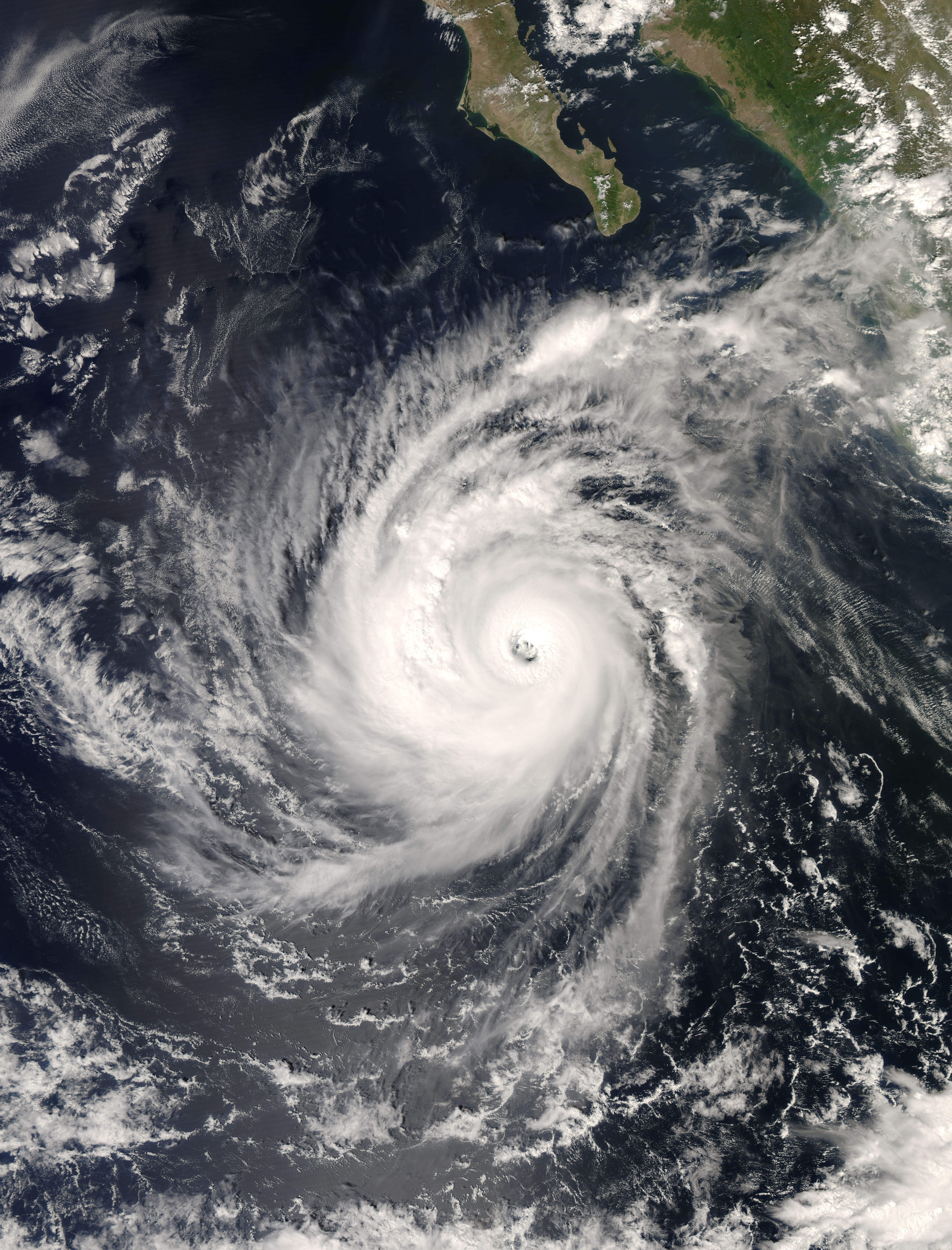
- Hurricane Norbert (2008)
Infobox hurricane current
name=Hurricane Norbert
time=5 p.m. PDTOctober 11 (0000 UTCOctober 12 )
category=cat1
type=hurricane
track=2008 15E 5-day track.gif
location=25.7°N 110.3°W ± 25 nm
About 70 mi (115 km) ESE of Loreto
About 75 mi (120 km) W of Los Mochis
1sustained=80 knots ! 90mph ! 150km/h
gusts=105 knots ! 120 mph ! 195 km/h
pressure=970mbar (hPa ) ! 28.64inHg
movement=NE at 13 kt ! 15 mph ! 24 km/hHurricane Norbert is the strongest storm thus far in the
2008 Pacific hurricane season . Norbert is the fifteenthtropical cyclone , fourteenth named storm, seventh hurricane of the season, and second major hurricane of the season.Meterological history
The origins of Norbert were from a area of disturbed weather that formed near the
Gulf of Tehuantepec on September 28.cite web|author=Blake|date=2008-09-28|title=Tropical Weather Outlook|publisher=National Hurricane Center |accessdate=2008-10-07|url=ftp://ftp.met.fsu.edu/pub/weather/tropical/Outlook-P/2008092817.ABPZ20] Drifting westward off the coast of Mexico, the system initially consisted of a broadlow pressure area and an area of disorganized convection.cite web|author=Beven|date=2008-09-29|title=Tropical Weather Outlook|publisher=National Hurricane Center |accessdate=2008-10-07|url=ftp://ftp.met.fsu.edu/pub/weather/tropical/Outlook-P/2008093005.ABPZ20] It slowly organized for several days, and by early on October 4 the system developed enough organized convection to be classified as Tropical Depression Fifteen; at that point, it was located about convert|230|mi|km south ofAcapulco . The depression was located over an area of warm water temperatures and moderate verticalwind shear , and as such was forecast to intensify gradually.cite web|author=Stewart|date=2008-10-04|title=Tropical Depression Fifteen Discussion One|publisher=National Hurricane Center |accessdate=2008-10-07|url=http://www.nhc.noaa.gov/archive/2008/ep15/ep152008.discus.001.shtml]About six hours after forming, the circulation of the depression became exposed from the deep convection, due to the wind shear. At the same time, two
tropical cyclone forecast model s predicted thetropical cyclogenesis of a larger disturbance to the southeast of the depression.cite web|author=Roberts|date=2008-10-04|title=Tropical Depression Fifteen Discussion Two|publisher=National Hurricane Center |accessdate=2008-10-07|url=http://www.nhc.noaa.gov/archive/2008/ep15/ep152008.discus.002.shtml] One model predicted the new cyclone to absorb the depression, although most other models forecast for the depression to remain the dominant system.cite web|author=Avila|date=2008-10-04|title=Tropical Depression Fifteen Discussion Three|publisher=National Hurricane Center |accessdate=2008-10-07|url=http://www.nhc.noaa.gov/archive/2008/ep15/ep152008.discus.003.shtml] By early on October 5, deep convection developed and organized around the center of the depression, and satellite intensity estimates using theDvorak technique suggested tropical storm force winds; as a result, theNational Hurricane Center (NHC) upgraded the depression to Tropical Storm Norbert, about convert|245|mi|km|abbr=on south ofZihuatanejo .cite web|author=Stewart|date=2008-10-05|title=Tropical Storm Norman Discussion Five|publisher=National Hurricane Center |accessdate=2008-10-07|url=http://www.nhc.noaa.gov/archive/2008/ep15/ep152008.discus.005.shtml?] Norbert was upgraded to a hurricane on October 6.cite web|date=2008-10-06|author=Berg/Stewart|url=http://www.nhc.noaa.gov/archive/2008/ep15/ep152008.discus.013.shtml?|title=Hurricane Norbert Discussion Number 13|publisher=National Hurricane Center |accessdate=2008-10-07] On October 7, it reached Category 2 intensity on theSaffir-Simpson Hurricane Scale .cite web|url=http://www.nhc.noaa.gov/archive/2008/ep15/ep152008.discus.017.shtml?|title=Hurricane Norbert Discussion Number 17|author=Beven|date=2008-10-07|publisher=National Hurricane Center |accessdate=2008-10-07] Overnight, an eye appeared on infrared satellites, indicated that Norbert was intensifying and was upgraded to a major hurricane respectively. Continuing to strengthen, it reached Category 4 that afternoon, before weakening into a Category 1 by October 9, but restrengthened into a minimal major hurricane 0n October 11, and made landfall that day as a category 2.cite web|url=http://www.nhc.noaa.gov/archive/2008/ep15/ep152008.discus.018.shtml?|title=Hurricane Norbert Discussion Number 18|author=Avila|date=2008-10-08|publisher=National Hurricane Center |accessdate=2008-10-08]Impact and naming
Hurricane Norbert struck Mexico's Baja California peninsula on Saturday with torrential rains and winds of up to 155 km/h. Strong winds bent palm trees along coastal areas. Some streets were in knee-deep water in the town of Puerto San Carlos. Norbert was a Category 2 hurricane at landfall, which made Norbert the first
October hurricane to strike the Baja California peninsula since Hurricane Pauline forty years prior, and Norbert was the stronger of the two.When Tropical Depression Fifteen-E strengthened into Tropical Storm Norbert late on October 4, it marked the first time worldwide that a storm had been named Norbert in 18 years; the last time a tropical cyclone in any basin was given the name was in the
1990 Pacific hurricane season , although it was also previously used in the 1984 season.cite web|url=http://www.nhc.noaa.gov/tracks1949to2007_epa.txt|date=2008-03-21|title=Eastern North Pacific Tracks File 1949-2007|accessdate=2008-10-07|publisher=National Hurricane Center |format=plaintext]Preparations
A hurricane warning was issued on
October 10 for parts of central Baja California from Puerto San Andresito southward to Agua Blanca, and they extended around the peninsula from La Paz to Loreto. The warnings also went on the mainland west coast from Topolobampo to Guaymas. Hurricane watches were issued from Agua Blanca to Cabo San Lucas, and extended around the Baja peninsula to La Paz, and these same areas were also under tropical storm warnings as well. Tropical storm warnings also extended from Loreto northward to Mulege on the eastern side of the peninsula.Current storm information
As of 2 p.m. PDT (2100 UTC)
October 11 , Hurricane Norbert is located within 25nautical mile s of 25.2°N 110.9°W, about 65 mi (100 km)south-southeast of Loreto and about 125 mi (200 km)west-southwest of Los Mochis. Maximum sustained winds are 85 knots (100 mph, 155 km/h), with stronger gusts. Minimum central pressure is 970mbar (28.64 inches), and the system is moving NNE at 13 kt (15 mph, 24 km/h).Hurricane-force winds extend out up to 35 mi (55 km) from the center of Norbert, and tropical storm-force winds extend out up to 125 mi (205 km) from the center of Norbert.
Watches and warnings
As of 2 p.m. PDT (2100 UTC)
October 11 , the following warnings and watches are in effect:For latest official information see:
*The NHC's [http://www.nhc.noaa.gov/text/refresh/MIATCPEP5+shtml/ latest public advisory on Hurricane Norbert] .
*The NHC's [http://www.nhc.noaa.gov/text/refresh/MIATCMEP5+shtml/ latest forecast/advisory on Hurricane Norbert] .Aftermath
Refs
Links
* [http://www.nhc.noaa.gov/text/MIATWOEP.shtml National Hurricane Center's Eastern Pacific Tropical Weather Outlook] - updated four times daily
* [http://www.nhc.noaa.gov/ National Hurricane Center]
Wikimedia Foundation. 2010.
