- Concepción Chiquirichapa
-
Concepción Chiquirichapa — Municipality and town — 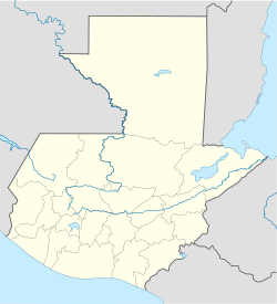
 Concepción Chiquirichapa
Coordinates: 14°51′N 91°37′W / 14.85°N 91.617°W Country  Guatemala
Department Quetzaltenango Time zone Central Time (UTC+6) Concepción Chiquirichapa is a municipality in the Quetzaltenango department of Guatemala. The municipality of Concepción Chiquirichapa, is part of the 81 municipalities in the Western Highlands of Guatemala. This region "is located in the mountains of the Sierra Madre Mountains at an altitude of 1,500 meters above sea level, composed of 81 municipalities totaling 9.107 square kilometers and 1,613,678 inhabitants 4.957 localities, departments Totonicapán, Solola the highlands of San Marcos and Quetzaltenango, Huehuetenango Southern and Western Quiche and Chimaltenango. Represents 8.36% of the country and 19.37% of the total population. (...)
The continuity of the natural environment, socioeconomics smallholder rural peasant, the Mayan cultural substrate, poverty and the scope of social actors involved in regional development have been the criteria to delimit it. (...) Presents physiographic heterogeneity, temperate climates, soil diversity and a set of river basins (Pacific, Chixoy, the Grijalva and the Motagua) that provide national and international importance.
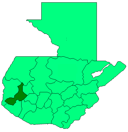
MICRO LOCATION The municipality of Concepción Chiquirichapa, is one of 24 municipalities in the department of Quetzaltenango located in the center thereof to 2.565 meters over sea level with latitude 14 ° 51 '20 "and longitude 91 ° 37' 26" and same at 214 kilometers from the capital city and 14 kilometers from the departmental capital of Quetzaltenango, with which it communicates via a two-way paved road, over which transit vehicles with high, medium and low tonnage and is passable during all year, is currently in good shape.
Longitude, latitude, LIMITED
The municipality of Concepción Chiquirichapa is within the location parameters as follows:
Altitude of 2.565 meters above the sea; Latitude 14 º 51 '20 Longitude 91 º 37 'and its municipal boundaries can be seen in the map of the municipality of Concepcion Chiquirichapa are: the territory is bounded by 5 municipalities, which we described as follows:
LIMITS OF THE MUNICIPALITY OF CONCEPCION Chiquirichapa
"North", limited to two neighboring municipalities known as the "San Juan Ostuncalco" and "San Mateo", with these three rural communities that are adjacent are village "The Duraznal", "Excomuchá" and "San Cristobal".
"South" is limited to two major towns are: "San Martín Sacatepéquez", this limit hamlets "To-Xucuwé" and "Toj-Corral," we can say that the southern mountainous area "Chiquirichapa" limited with the municipality of El Palmar "and" Quetzaltenango ".
"East" of the territory bordered by the municipality and a department that is "St. Matthew" and "Quetzaltenango", with these four communities are limited: the village above "Talmax", "Tuilcanabaj" and "Tuikbal", and " Cerro Siete Orejas.
"West" of the municipality can be seen at two adjacent villages which are "Ostuncalco" and "San Martín Sacatepéquez" with these limits the "Cerro Tuicacaix", which belongs to Chiquirichapa.
The municipality of Concepción Chiquirichapa, is located in the central part of the department of Quetzaltenango and how much with a land area of 48 square miles (120 km2), the weather is cold. It lies at a distance of 18 km. of the departmental capital of Quetzaltenango and 237 km. capital city of Guatemala.
DISTANCESThe distance between the municipal and the municipality of Concepcion Chiquirichapa covers various aspects between them are: communities, distance in miles, time and time in minutes by car, which have different and varied situations as to where they are located, as can be seen in the following table:
CULTURE
------------------------------
RELIGION CUSTOMS AND TRADITIONS Market day ETHNICITY, RACE, LANGUAGE Costumes LEGENDS OF ORIGIN TYPICAL FOOD AND DRINK ORIGIN OF NAME
RELIGION
The inhabitants of the municipality of Conception Chiquirichapa been identified with spirituality among the living is belief in a supreme being that governs the way the community. There is Evangelical or Protestant churches where the people come daily to ask u please to thank, to honor the Supreme Being according to their beliefs, there is the Catholic Church in colonial structure which receives every day Catholics to be focus for prayers to the Creator.
CUSTOMS AND TRADITIONS
The festivity is celebrated usually from 5 to 9 December, being the main day 7, when the church celebrates in honor of the Conception of the Virgin Mary. In the cultural aspect of this village, on December 7 leaving the Virgin Mary in procession through the principal streets and avenues of the great blessings municipal shedding according to the beliefs of this people, upon entering the procession takes place the burning of the fireworks every year that is being developed in the churchyard. On 8 and 9 December, entertainment perform several musical groups in the churchyard, so people celebrate the holiday of this people as tradition and custom of indigenous Mam. The second holiday of this county is carried out on July 22 in honor of "Our Lady of Magdalene."
Market day
It is the day Sunday and Thursday in the square there is trade and also the happiness of sharing joys, sorrows and sadness.ETHNICITY, RACE, LANGUAGE
This group points to 21.349 inhabitants in the municipality of Concepcion Chiquirichapa are purely indigenous Mam, but also recorded, non-indigenous, meaning that they are white men.
Costumes
The costume worn by the women is the Huipil Red, black cut, strip, strip was produced by the same women in the municipality, the color is red huipil its meaning is the blood spilled by our ancestors cut the dark or black evening, the bar the nagual of Women, the belt force and purity of women.
LEGENDS OF ORIGIN
There is now a legend of origin and formation of the municipality of Concepcion Chiquirichapa by oral tradition which has been moving from generation to generation, the release says "In ancient times, the ancestors lived in this county on top of a hill located alongside the hill "Tuicacaix" started to build homes, then continued to work achieving complete the construction of a wooden church where they began to have their first religious activities. The town center was called by neighbors in the dialect "Mam" with the name "Twisak Bajlak", translated in Spanish means "Place of White Shilote" they called it with that name because at that time planted corn, which were mostly ears "SHILOTE WHITE". The population remained for a period on that hill, most of them worked in agriculture and they were returning from their work, the housewives to their husbands reported that several children had disappeared in the community, neighbors became concerned about the small , mothers could not care for their children for work they performed at home, the whole community soon realized that the giant birds called "TIW" were responsible for several missing children in the community, assuming that they are had led to their nests for food. The children devised a mechanism to protect infants from birds by covering the head with a basket, yet when they neglect to cover, they are still in progress. The villagers were struggling to kill the animals because their nests were very high, these were located in front of a mountain where no one could climb, however, the nests found by a few people were like a "tunnel" involving a diameter of 2 meters, the depth of it never knew he had. In this situation, the leader of the settlers are forced to seek other shelter, for it met several men and instructed to search, after a while the site was not found so the Principal made use of his stick (which had some power) placed on top of a mountain called "TO-XUCUWE" said mountain to the power of the stick is moved, this meant that the site was not suitable for occupancy. Before this second failure, the search continued walking up the hill "POPBIL" where since then planted the stick, as at no time moved the hill above, all the chief companions were overjoyed at having found the site to the shore of the lake, where once buried their dead, the area was safe for them to establish a good time so it returned to the community. with the good news that they had found a good area for refuge. That's how this group left the area where they were installed, leaving only the remains of a church that still exists today in the dialect called "Mam" with the name "Tui Glesbén" which translated into Castilian means "Place Where There was the Church. " The site of the dead was inhabited by the settlers in what today is "The Leader Chiquirichapa Municipal de Concepción. On this site, soon after the natives had the same problem, the birds were still threatening the children, still protected by their parents, with a small child neglect disappeared. Given this, one day met the strongest men of the population determined from the mountains to fill the huge birds' nests, but the initiative was not bad, neighbors were able to seal the tunnels, the birds could not leave nests there were dead and never again do more harm to the community. Another problem faced by members of the community and always associated with infants, is that they went into the lake and never came back, before this, the Principal who had used his power under a cane or tubes forming long sticks and using a piece of cotton, begged the gods to withdraw from the lake making the water disappear down the tube, ending talk, soak the cotton ball and put it on the tube formed by putting the east direction, water went up to the place that today is known as "Lake Atitlan", days after the water disappeared, leaving a huge valley, with this, the problem was solved, the children could leave their homes without the danger represented the huge birds and the nearby lake. All these lands belonged to the natives of the village of "Chiquirichapa" which to their growth, the highest authority of the people ordered to leave a few families to care for the forests of the north and south, over time these are multiplied and formed their own communities such as San Juan Ostuncalco "," Cajolá "," San Miguel Sigüilá "," San Martin Sacatepequez "," Warsaw "," Monrovia "and elsewhere, which with the passage of time, formed municipalities. For these reasons, it is shown that this town is older than the others and can say that this has arisen all other surrounding places.TYPICAL FOOD AND DRINK
Food is clearly typical among them we can mention the following: Pepi, Jocón, Beef tripe soup, chicken broth, bouillon Pata, Hoe and Raising Meat, Preserved Beef Chicken and Egg Wrapped including any vegetable (potato , huisquil, green beans, carrots and tortillas). And there is the typical drink and Such mass Atol.ORIGIN OF NAME
Its etymology comes from the Nahuatl words of Mexican origin, Chiquilichtl-a-pan, meaning "The stream of cicadas or locusts" that interpretation from the analysis of the roots following Chiquilich (grasshopper or cicada), Atl. (water) and bread (instead). Subsequently the conquest, the role that the Catholic Church was very influential, so that the name "Conception" was attributed to honor the Virgin Conception, come to be known well for many years, with the events of the liberation movement by General "Justo Rufino Barrios, the occurrence that the Church had in the political, cultural and social life space and thus lost the influence it had on the municipalities, so in the year 1860 by Government, the municipality he is even changing the name to "Concepcion Chiquirichapa.
Capital: QuetzaltenangoMunicipalities Almolonga · Cabricán · Cajolá · Cantel · Coatepeque · Colomba · Concepción Chiquirichapa · El Palmar · Flores Costa Cuca · Génova · Huitán · La Esperanza · Olintepeque · Palestina de Los Altos · Quetzaltenango · Salcajá · San Carlos Sija · San Francisco La Unión · San Juan Ostuncalco · San Martín Sacatepéquez · San Mateo · San Miguel Sigüilá · Sibilia · Zunil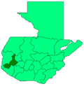 Categories:
- Municipalities of the Quetzaltenango Department
- Populated places in Guatemala

Wikimedia Foundation. 2010.