- Taunggyi
Infobox Settlement
official_name = Taunggyi
other_name =
native_name = _my. ေတာင္ႀကီး
nickname =
settlement_type =
motto =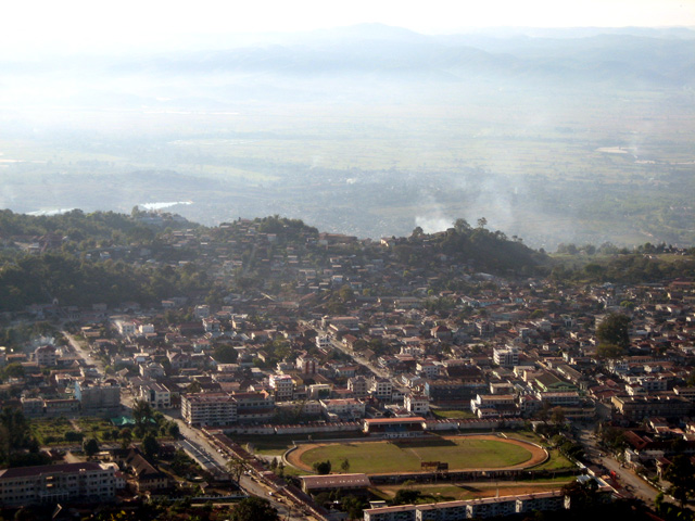
imagesize =
image_caption = A view of Taunggyi
flag_size =
image_
seal_size =
image_shield =
shield_size =
image_blank_emblem =
blank_emblem_type =
blank_emblem_size =
mapsize =
map_caption =
mapsize1 =
map_caption1 =
image_dot_
dot_mapsize =
dot_map_caption =
dot_x = |dot_y =
pushpin_
pushpin_label_position =bottom
pushpin_map_caption =Location of Taunggyi, Myanmar (Burma)
subdivision_type = Country
subdivision_name =Myanmar (Burma)
subdivision_type1 = Admin. division
subdivision_name1 =Shan State
subdivision_type2 =
subdivision_name2 =
subdivision_type3 =
subdivision_name3 =
subdivision_type4 =
subdivision_name4 =
government_footnotes =
government_type =
leader_title =
leader_name =
leader_title1 =
leader_name1 =
leader_title2 =
leader_name2 =
leader_title3 =
leader_name3 =
leader_title4 =
leader_name4 =
established_title = Founded
established_date = 1894
established_title2 =
established_date2 =
established_title3 =
established_date3 =
area_magnitude =
unit_pref =Imperial
area_footnotes =
area_total_km2 =
area_land_km2 =
area_water_km2 =
area_total_sq_mi =
area_land_sq_mi =
area_water_sq_mi =
area_water_percent =
area_urban_km2 =
area_urban_sq_mi =
area_metro_km2 =
area_metro_sq_mi =
area_blank1_title =
area_blank1_km2 =
area_blank1_sq_mi =
population_as_of =
population_footnotes =
population_note =
population_total =200000
population_density_km2 =
population_density_sq_mi =
population_metro =
population_density_metro_km2 =
population_density_metro_sq_mi =
population_urban =
population_density_urban_km2 =
population_density_urban_sq_mi =
population_blank1_title =Ethnicities
population_blank1 =Bamar ,Burmese Chinese ,Burmese Indians ,Shan
population_blank2_title =Religions
population_blank2 =Animism ,Buddhism ,Islam ,Sikhism
population_density_blank1_km2 =
population_density_blank1_sq_mi =
timezone =
utc_offset =
timezone_DST =
utc_offset_DST =
latd=20 |latm=47 |lats= |latNS=N
longd=97 |longm=02 |longs= |longEW=E
elevation_footnotes =
elevation_m = 1400
elevation_ft =4590
postal_code_type =
postal_code =
area_code =
blank_name =
blank_info =
blank1_name =
blank1_info =
website =
footnotes = Taunggyi (MYname|MY=တောင်ကြီးမြို့|MLCTS=taung kri: mrui.), is the capital ofShan State ,Myanmar . Taunggyi has a population of approximately 200,000, making it the fourth largest city in Myanmar (behindMawlamyaing ), and is at an elevation of 4,590 feet (1,400 m) above sea level. The name Taunggyi means "big mountain" in the Burmese language, and is named after the ridge on the east of the city, and the prominent high point on it is called the Taung-chun or "The Crag." Although within the Shan State, the Shans are not the predominant population of this city. The Inthas and the Pa-Os form the most visible population. Recently there has been a flood of Chinese immigrants. Taunggyi lies within theMyelat region of Shan State.History
Prior to British colonisation, Taunggyi was a small village of a few huts. The area lay on a wide shoulder of the Sintaung Hills of the Shan Plateau and was populated by the
Pa-O ethnicity at the time. The signs of the original village of Taunggyi are long gone, but nearby villages can still be discerned quite easily.During British occupation, the town became the chief city and capital of the Southern Shan States. Taunggyi's modern development began in 1894, when the British moved their administrative offices from
Maing Thauk (Fort Stedman) on the eastern shores of Inle Lake to the higher elevation of Taunggyi, for health and geographical reasons. Although geographically within the state ofYawnghwe , the town was denoted as a "notified area" by the British, exempt from theSawbwa 's administration. By 1906, there existed a thousand houses. Because of civil unrest throughout the Shan States during the early 1900s, Taunggyi served as the chief garrison for military police. Taunggyi also served as a supply centre for the Shan States, and catered to persons of many nationalities.Transportation
The main access to Taunggyi is by road. A railway line that passes through Taunggyi was recently built in 1995, but at the moment it offers no passenger service. Regular railway passenger service to the rest of the country is through the town of Shwenyaung, twelve miles to the west. The nearest airport is in the town of
Heho , mi to km|24|wiki=yes by road to the west of Taunggyi.Culture
Taunggyi is the melting pot for the Myelat area of the Shan State. In addition to the indigenous
Pa-O andIntha , there is a significant population of Shans,Bamar s, other native ethnic minorities, as well as Chinese andBurmese Muslims . Like in most of Myanmar, influence of Buddhism is most evidenced by the monasteries scattered throughout the city. However, being a relatively new city, the monasteries are not of historical significance and architecturally not unique. There is also a significant Christian population, as the center of the Roman CatholicArchdiocese of Taunggyi the St. Joseph's Cathedral and its associated seminary are the main facilities, as well as a Baptist Church, both established by early missionaries. There is also a smallerAnglican church , which originally served the British administrators, but recently it has fallen into a state of disrepair. Fourmosque s serve the Muslim population of the city, Myo Oo Pali, A Lae Pali and Taung Pali are for large population of Burmese Muslims, and Panthay Pali for the ChinesePanthay Muslims. There are also a few temples serving the Chinese Buddhist community.The Taunggyi area is a popular tourist destination. The city itself has an interesting five-day market, where farmers from around the area would come to the Taunggyi on market day and sell fresh produce in the open market, but with more development of the city, the significance of market day has been lessened. However, the market-day tradition continues strong in the outlying small towns. Nearby, Inlay Lake is the home of the unique Intha culture. The drive to the
Pindaya Caves provides a good view of theMyelat country. Nearer to Taunggyi at the Kat-ku, one can see hundreds of stupas dating to the 16th century.There is no significant industry in Taunggyi. It used to be the trans-shipment point for many of the agricultural products of southern Shan State. However, due to recently imposed zoning regulations, most of these operations have been moved to the surrounding new town of Ayetharyar.
Being the capital of the Shan State, Taunggyi hosts many government offices. There is a museum in town which has displays on the Shan culture, as well as items of historical interest, such as belongings of the
Sawbwas . The city is also the headquarters of Eastern Command of theTatmadaw (Burmese Army), and the army occupies a significant portion of the northeast area of the city.The city is home to the
Taunggyi Education College andTaunggyi University .Shan State Cultural Museum -the state museum lies in Taunggyi.References
*1911

Wikimedia Foundation. 2010.