- Namjung
-
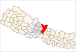
Namjung,gorkha — Village development committee — Location in Nepal Coordinates: 27°56′N 84°43′E / 27.94°N 84.71°ECoordinates: 27°56′N 84°43′E / 27.94°N 84.71°E Country  Nepal
NepalZone Gandaki Zone District Gorkha District Population (1991) – Total 3,370 Time zone Nepal Time (UTC+5:45) Namjung is a village development committee in Gorkha District in the Gandaki Zone of northern-central Nepal. At the time of the 1991 Nepal census it had a population of 3,370 and had 627 houses in the town.[1]
Namjung is situated in the southeast part of the district in between Fujel khola and Baikhola in southern and Northern part and Budhi Gandaki in eastern part.Which is extended from 500 masl to 2500 masl.The mid hill VDC which is near around 165 km far from Kathmandu if you will use the way of Gorkha Bazzar, but there is another way Kathmandu-Benighat- Namjung which is around 120 km far from Kathmandu. The concrete moterable bridge is being constructed in Benighat. after building of this bridge, it will incresse the economic activities of eastern and southern as well as northern part of Gorkhas' people. There is another moterable bridge is constructing in Bunkot Ghat. There is going to be constructed a big hydro power in Budhi Gandaki river, which also affects the lower belt, Majhitar and Dhatuwatar. This hydro power has 650 MW which is higher than all total hydro power which has constructed in Nepal till the time. Whose catchment area will be 10 times larger than the Fewa lake.
The main pleces of the Namjung are Majhitar, Dhatuwatar, Gangatetar, Ratmate, satdobate, Dhuseni, Rambhanjyang, Chhapgaun, Khadkagaun, Chautara Danda,Khanidanda, Pokhari, Gurungung Gaun, Seprak, Danda Gaun, Hukkaban, Gairhi Gaun, Archale.
The main population of Namjung are Brahmin followed by Chetri, Newar, Gurung, Kami, Damai, Baram and Magars. There are four primary schools and one High school. The VDC is connected with District headquarter Gorkha Bazzar with unpaved motarable road. There is also facility of eleticity, telephone.
The main occupation of Namjung's people is agriculture, they produce rice as main crop in low land and uplnad in rainy season. Maize is the another main crop and Finger Millet as third one. The current agriculture is subsistence type but some of farmers have commercial one. They produce seasonal vegetable, fruits and sugarcane. Namjung has good rainforest in the lower part or in the foothills of mountains covered with Sal trees(Sorea robusta), Chilaune trees( Schima walichii), Saaj, Kadam (Anthesephaloes kadamba) etc. In the foothill of mountain, it has plain land called Majhitar, Dhatuwatar and Gangatetar. Thease places have large terraces.
References
- ^ "Nepal Census 2001". Nepal's Village Development Committees. Digital Himalaya.
 Aanppipal, Aaru Arbang, Aaru Chanuate, Aarupokhari, Asrang, Baguwa, Bakrang, Bhirkot, Bhumlichok, Bihi, Borlang, Bunkot, Chhaikampar, Chhoprak, Chumchet, Chyangli, Darbhung, Deurali, Dhawa, Dhuwakot, Finam, Fujel, Gaikhur, Gakhu, Ghairung, Ghyachok, Ghyalchok, Gorakhkali, Gumda, Hansapur, Harbhi, Jaubari, Kashigaun, Kerabari, Kerauja, Kharibot, Khoplang, Laprak, Lapu, Lho, Makaising, Manakamana, Manbu, Masel, Muchhok, Namjung, Nareshwor, Palumtar, Panchkhuwadeurali, Pandrung, Prithbinarayan, Prok, Ranishwara, Samagaun, Saurpani, Shreenathkot, Simjung, Sirdibas, Swara, Taklung, Takukot, Takumajhalakuribot, Tandrang, Tanglichok, Taple, Tara Nagar, Thalajung, Thumi, Uiya, Warpak
.
Main places that can be visited are gandaki river, barchuli temble, bhimsen temple(satal), kauri Pani etc.
Categories:- Populated places in Gorkha District
- Gandaki Zone geography stubs
Wikimedia Foundation. 2010.

