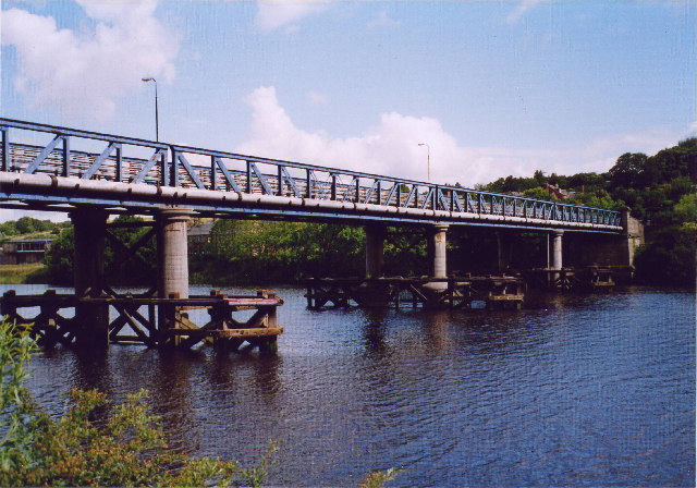
Newburn Bridge

Newburn Bridge
Newburn Bridge

Newburn Bridge viewed from the south east, June 2004
Carries Road
Water mains
Gas mains
Telephone wires
Crosses River Tyne
Locale Tyne and Wear, England
Design 4 span steel lattice-girder on three wrought iron, concrete-filled cylinders.
Total length 144.8 m (475 ft)
Width 8.54 m (28.0 ft)
Construction begin 1892
Construction end 1893
Opened 1893
Toll Stopped 1947
Daily traffic Single road controlled by traffic lights.

Newburn Bridge is a road bridge crossing the River Tyne at Newburn in Newcastle upon Tyne, England. It links Newburn, Walbottle and Throckley on the north side of the river with Ryton, Stella and Blaydon on the south side. The bridge is the western most crossing of the Tyne in the county of Tyne and Wear; the next crossing upstream, Wylam Bridge, is in Northumberland.

History

This part of the river has been forded since Roman times because it is the most eastern part of the Tyne that is easily fordable. There have also been numerous ferries operated in the part of the river around Newburn. A bridge was finally built between 1892 and 1893. It was designed by Sandeman & Moncrieff of Newcastle and built by Head Wrightson of Thornaby-on-Tees. It was opened on 21 May 1893. For the first 50 or so years of its use it was a toll bridge, until it was bought by Northumberland in 1947. The toll house on the north east side of the bridge has since been demolished. The bridge used to have two lanes crossing it up until the 1960s. It has since had single road traffic because of the weight limit of 9 tonnes (8.858 long tons; 9.921 short tons), later raised to 10 tonnes (9.842 long tons; 11.02 short tons).

In 2007 the bridge was closed for a number of months for renovation and repainting.

References


Next crossing upstream River Tyne Next crossing downstream
Wylam Bridge  Newburn Bridge
Grid reference: NZ162651
Blaydon Bridge
(A1 road ) 

Coordinates: 54°58′48″N 1°44′42″W / 54.980°N 1.745°W / 54.980; -1.745


Wikimedia Foundation. 2010.

Игры ⚽ Поможем сделать НИР

Look at other dictionaries:

  • Newburn railway station — Newburn The site of Newburn station in 2008 Location Place Newburn …   Wikipedia

  • Newburn — Coordinates: 54°58′59″N 1°44′35″W / 54.983°N 1.743°W / 54.983; 1.743 …   Wikipedia

  • Wylam Railway Bridge — Infobox Bridge bridge name=Wylam Railway Bridge caption=Wylam Railway Bridge as seen from the south bank of the River Tyne. official name= locale =Northumberland, England carries=Footpath Cycleway formerly Railway crosses=River Tyne maint= begin …   Wikipedia

  • Stella Power Station — Infobox UK power station static static image caption=Stella North and South Power Stations. Viewed from Newburn Bridge on 31 October 1987. Stella North is on the left and Stella South is on the right. os grid reference=NZ175644 latitude=54.974278 …   Wikipedia

  • River Tyne — For other uses, see River Tyne (disambiguation). Coordinates: 55°0′37″N 1°25′8″W / 55.01028°N 1.41889°W / 55.01028; 1.41889 …   Wikipedia

  • Head Wrightson — was a big heavy industrial firm based at Thornaby on Tees on Teesside in England. They specialised in the manufacture of large industrial products such as fractional distillation columns that needed special transport to get them to site. Its… …   Wikipedia

  • Newcastle and Carlisle Railway — A ScotRail Class 156 unit pauses at Hexham Overview Type Heavy rail …   Wikipedia

  • Newcastle upon Tyne — This article is about the English city. For other uses, see Newcastle. Coordinates: 54°58.440′N 1°36.792′W / 54.974°N 1.6132°W / 54.974; 1 …   Wikipedia

  • North East England — This article is about the region. For the European constituency, see North East England (European Parliament constituency). North East England North East region shown within England Geography Status Region Area …   Wikipedia

  • Wylam — infobox UK place static static image caption = Wylam war memorial country = England official name= Wylam latitude= 54.974 longitude= 1.821 population = 2,100 shire district= Tynedale region= North East England shire county = Northumberland… …   Wikipedia

Share the article and excerpts

Direct link
Do a right-click on the link above
and select “Copy Link”