Rivière du Rempart (district)
- Rivière du Rempart (district)
Infobox Dist and Dep MU
name=Rivière du Rempart District
capital=Mapou
population=98,854
population_as_of=2000
pop_rank=N/A
area=148
area_rank=N/A
pop_dens=667.93
places=N/A
area_code=N/A
ISO=MU-RR (Rivière du Rempart)
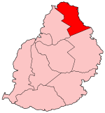
Rivière du Rempart is a district of Mauritius. It is located in the North-East of the country. Its capital is Mapou but its biggest town is the tourist resort of Grand Bay.
Overview
Among some of the big towns like Cap Malheureux or Grand Gaube in the coastline, it also comprises some touristic places like Plaine des Papayes and Antoinette, where the first indentured labourers from India settled.
Rivière du Rempart are linked by two roads and is located northeast of Port Louis and north of Grand Port.Goodlands is a very popular shopping town.It is small but bustling with traders.It is also fast becoming a popular shopping venue for tourists as the prices of goods there are much lower than those in Port Louis.Goodlands has a market which trades a few times a week.Nearby there is the coastal village of Grand Gaube.Initially a small fishing village,but now it boasts the presence of a small golf course,3 hotels and a very friendly welcome awaits people visiting the village.Grand Gaube makes a very interesting drive when you use the scenic coastal route to Grand Bay and Cap Malheureux.. There are also beautiful villages in the coastal area like Poudre D'Or Village and Poudre D'Or Hamlet. Melville is also a small village about 1.3 km from Grand Gaube.It is beautiful,wealthy and it is believed to boast the highest number of PhDs per capita in the whole island.
Wikimedia Foundation.
2010.
Look at other dictionaries:
Rivière du Rempart — can refer to one of two different geographical features of Mauritius:*Rivière du Rempart (district) *Rivière du Rempart (river) … Wikipedia
Riviere du Rempart — Basisdaten Bezirkshauptstadt: Mapou Fläche: 148 km² Einwohner: 98.854 (2000) Bevölkerungsdichte: 667,93 Einwohner/km² Offizielle Webseite ISO 3166 2 code … Deutsch Wikipedia
Rivière du Rempart (river) — The Rivière du Rempart is a river in northeast Mauritius. It is the outflow of la Nicolière, a lake in the central north of Mauritius, and flows northeast to reach the Indian Ocean north of Poste de Flacq. The river gives its name to the Rivière… … Wikipedia
Riviere du Rempart — Rivière du Rempart Cet article concerne le district de l île Maurice. Pour le fleuve, voir Rivière des Remparts. Le district de Rivière du Rempart. Rivière du Remp … Wikipédia en Français
Rivière du rempart — Cet article concerne le district de l île Maurice. Pour le fleuve, voir Rivière des Remparts. Le district de Rivière du Rempart. Rivière du Remp … Wikipédia en Français
Rivière du Rempart — 20°03′S 57°38′E / 20.05, 57.633 … Wikipédia en Français
Association Sportive de la Rivière du Rempart — Infobox club sportif Association Sportive de la Rivière du Rempart Pas de logo ? Importez le logo de ce club. Généralités Nom complet … Wikipédia en Français
Riviere Noire — Rivière Noire Le district de Rivière Noire. Le … Wikipédia en Français
Rivière-Noire — Le district de Rivière Noire. Le … Wikipédia en Français
Riviere des Remparts — Rivière des Remparts Cet article concerne le fleuve français. Pour le district de l île Maurice, voir Rivière du Rempart. Rivière des Remparts Partie haute … Wikipédia en Français