- Polomolok, South Cotabato
Infobox Settlement
official_name = Municipality of Polomolok
other_name =
native_name =
nickname =
settlement_type =
motto =
imagesize =
image_caption =
flag_size =
image_
seal_size =
image_shield =
shield_size =
city_
citylogo_size =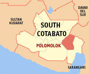
mapsize =
map_caption = Map ofSouth Cotabato showing the location of Polomolok. Coordinates: 6°7'N 125°10'E
mapsize1 =
map_caption1 =
pushpin_
pushpin_label_position =
pushpin_map_caption =
pushpin_mapsize =
subdivision_type = Country
subdivision_name =Philippines
subdivision_type1 = Region
subdivision_name1 =SOCCSKSARGEN (Region XII)
subdivision_type2 = Province
subdivision_name2 =South Cotabato
subdivision_type3 = Districts
subdivision_name3 = 1st District of South Cotabato
subdivision_type4 =Barangays
subdivision_name4 = 23
subdivision_type5 =
subdivision_name5 =
government_type =
leader_title = Mayor
leader_name = Isidro D. Lumayag (KAMPI) (2007-2010)
leader_title1 = Vice Mayor
leader_name1 = Ligaya R. Orbesido (KAMPI) (2007-2010)
leader_title2 =
leader_name2 =
established_title =
established_date =
established_title2 = Incorporated (town)
established_date2 =1948
established_title3 =
established_date3 =
area_magnitude =
unit_pref =
area_footnotes =
area_total_km2 =
area_land_km2 =
area_water_km2 =
area_total_sq_mi =
area_land_sq_mi =
area_water_sq_mi =
area_water_percent =
area_urban_km2 =
area_urban_sq_mi =
area_metro_km2 =
area_metro_sq_mi =
population_as_of = 2000
population_footnotes =
population_note =
population_total = 411,822
population_density_km2 = 637
population_density_sq_mi =
population_metro =
population_density_metro_km2 =
population_density_metro_sq_mi =
population_urban =
population_density_urban_km2 =
population_density_urban_sq_mi =
timezone = PST
utc_offset = +8
timezone_DST =
utc_offset_DST =
latd= |latm= |lats= |latNS=
longd= |longm= |longs= |longEW=
elevation_footnotes =
elevation_m =
elevation_ft =
postal_code_type =
postal_code =
area_code =
blank_name =
blank_info =
blank1_name =
blank1_info =
website = [http://elgu.ncc.gov.ph/ecommunity/polomolok-sc/ Municipality of Polomolok Website]
footnotes =Polomolok is a 1st class municipality of South Cotabato,
Philippines . Situated betweenGeneral Santos City andTupi . According to the 2000 census, it has a population of 110,709 people in 22,492 households. Polomolok is the home of Dole Philippines, one of the biggest pineapple production in the country.Barangay
Polomolok is politically subdivided into 23
barangay s.
* Bentung
* Crossing Palkan
* Glamang
* Kinilis
* Klinan
* Koronadal Proper
* Lam-Caliaf
* Landan
* Lumakil
* Maligo
* Palkan
* Poblacion
* Polo
* Magsaysay
* Rubber
* Silway 7
* Silway 8
* Sulit
* Sumbakil
* Upper Klinan
* Lapu
* Cannery Site
* PagalunganMajor Products
*Pineapple Production
Dole Philippines Incorporated is the largest industrial firm involved in growing, processing and exporting of fresh and canned pineapple. As of 2004, the area planted to pineapple is 15,507.872 hectares with an average production volume of 31.94 metric tons per hectare. This industry, which is situated at Barangay Cannery Site, generates about 6,000 jobs at present. It is considered as the biggest taxpayer in the municipality.
*Corn Production
Corn is the second most grown crop in the municipality. Data from the Office of the Municipal Agriculturist revealed that for the year 2003 there are 3,931 hectares or 13.46% of the total cultivated land agricultural lands were devoted to corn. About 1,236 hectares of which are planted to traditional corn seeds at average production of 3.20 MT/hectare and 2,695 hectares are planted to hybrid corn at average production of 4.0 MT/ hectare. The major producers are Barangay Klinan 6, Glamang, Landan, Silway 8 and Upper Klinan. About 30% of populace adopt corn as their staple food. Table 16 shows the Area Planted and Production of Corn by Barangay.
*Rice Production
Rice is also one of the major crops in the municipality. 70% of the total population has rice as their staple food. Office of the Municipal Agriculturist reported that for the year 2006, 445 hectares were utilized for rice production, of which only 300 hectares are irrigated, 45 are lowland, and 100 are upland. Irrigated areas are planted 2.5 time a year while rainfed and upland are planted only once. “Gintoang Masaganang Ani Program” Program targets for the average production of rice at about 4.5 MT, for irrigated, 3 MT for lowland and 1.5 MT for upland. This target was met by the farmers this year because of rice diseases and pest infestation.
Rice production of rice are not enough to supply the demand of the rice eating populace. Rice supply in the municipality depends on other rice producing areas in the region .
*Asparagus ProductionThe record of the Department of Agriculture shows that as of 2006, the total area planted with asparagus is 1,435.52 hectares. Plantations of this crop are in Barangay Sulit, Sumbakil, Crossing Palkan, Bentung, Lapu, Pagalungan, Lumakil, Rubber and Magsaysay. Farmer growers have access to the export market due to contract agreement with Marsman-Drysdale Agri-Ventures and Tropifresh. The surplus are sold in the local market and diversifically used as supplements for cattle fattening.
*Vegetable Production
Vegetables grow well in Barangay Palkan, Kinilis, Maligo, Sumbakil and Koronadal Proper where the climate is cool and the soil is fertile. However, the farmers cannot really produce in large volume due to financial constraints and unstable prevailing market prices of vegetables.
*Livestock and Poultry Production
Livestock and poultry production has increased tremendously in the past years. This is partly due to the municipality’s climate and terrain which is ideal for livestock and poultry production. The land area devoted for agri-livestock production is 80 hectares or 0.27 percent of the total agricultural land.
For the year 2006, the Office of the Municipal Agriculturist reported that there are 322,628 heads of livestocks and poultry raised in the municipality. Poultry has the most number of heads at 271,420 where 3,639 are layers, 17,852 are backyard, and 249,929 are commercial under contract growers scheme with different Agri-business firms such as RFM, Vitarich, and Swift followed by swine with 23,719 heads which 10,970 are backyard and a total of 15,113 are raised commercially, and cattle with 24,491 heads where 2,065 are backyard and a total of 22,426 heads fattened in the cattle farms of Montery and DEALCO.
Supply of livestock in the municipality is insufficient due to shipment of livestock which are raised commercially to other parts of the country leaving the backyard raisers to support the local market. The municipality still depend on supplies coming from other areas in the province.
Tourism
*MOUNT MATUTUM
The municipality’s most imposing landmark standing at 2,286 meters high. This is one of the favorite climb destination in SOCKSARGEN area.
*SALKAK CAVE
A place where nature lovers will experience the adventure of caving from stalactites and stalagmites to the cool springs and the fresh mountain breeze outside.
The cool spring of Natures Bounty and Spring Hill Resort manifest beauty and comfort in the coolness of its water during summer. These 2 medium resort is frequented by people from the Upper Valley and Sarangani Province.
*DOLE CANNERY
For tourists, Dole Cannery the vast pineapple and asparagus plantation is a scenario worth reminiscing.
*DOLE KALSANGI CLUB HOUSE
For the food gourmet, Dole Kalsangi Club House offers Western and Asian cuisine and drinks “ a la garde”.
*KALSANGI GOLF COURSE
Golf course at Kalsangi offers the aficionados a drive to conquer the 18th hole without miss or “puree”.
*TRAPPISTINE MONASTERY
The
Trappistine Sisters Monastery in Landan is also a place of worship and spiritual renewals. It is visited by pilgrims and benefactors within the country and abroad.*ESGUERRA FARM
The development of the vast Esguerra Farm in Kawit, Maligo as an eco-tourism area is another attraction. It is in this area where the flora and fauna could be easily revived through the active participation of NGO’s, PO’s and the full support from the municipal government.
External links
* [http://www.nscb.gov.ph/activestats/psgc/default.asp Philippine Standard Geographic Code]
* [http://elgu.ncc.gov.ph/ecommunity/polomolok-sc/ Municipality of Polomolok Website]
* [http://www.polomolok.com/ http://www.polomolok.com/]
Wikimedia Foundation. 2010.