- Holywell, Swords
Infobox Irish Place
name = Holywell
gaeilge = Tobar Naofa
crest
motto =
map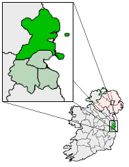
pin coords = left: 60px; top: 55px
north coord = 53.4433
west coord = 6.2103
irish grid =
area =
elevation =
province =Leinster
county =Fingal
dailconstituency = Dublin North
EU constituency = Dublin
town pop = ~1,500
IEpostcode =Co. Dublin
stdcode = 01, +353 1
rural pop =
census yr = 2006
web =Holywell (irish place name|Tobar Naofa) is a relatively new community near Swords,
Co. Dublin ,Ireland . Developed and marketed in phases and under various names, Feltrim Hall, Gorse Hill, Abbey Stone, Holywell and The Meadows, all the street names in the community include the common name Holywell e.g. 'Holywell Drive'.History
Founded in 2004, the community grew rapidly over its first four years. The development of social and recreational facilities has lagged behind the development of housing in the community, however recent developments have been seen in the building of a small commercial centre and the development of tennis court and football pitches. The name appears to be related to a "Holy Well" which is located near to the community although not on the actual site.
The Location
The community is located to the south east of Swords town, on the west side of the
Dublin toBelfast M1Motorway , the Swords junction off the M1 serves the estate and also provide a link to theAirside Retail Park and on to Swords.The centre of Swords is a 20 to 25 minute walk from Holywell estate and offers many of the amenities.
Local Transport links
The estate is served at peak times by the 142 bus route operated by
Dublin Bus , the closest stops being on the Drynam Interchange/R125, the dual carriageway that separates the northern and southern sections of the estate. The 142 gets to the city centre via the Dublin Port Tunnel.The estate is also served by the 43 bus route operated by
Dublin Bus . The closest stop is on the Feltrim Road beside the bridge over the M1Motorway . The 43 bus operates between Swords andDublin City Center, via theMalahide Road, Artane and Fairview. A revisedDublin Bus route 102 connects the estate to the Dart station in Malahide, from the same stop.Other
Dublin Bus routes are available outside both entrances to theAirside Retail Park . The Nevinstown stop of the proposedDublin Metro North line will also be located outside theAirside Retail Park .The Swords Express bus service passes by both entrances to the
Airside Retail Park and goes toDublin city centre via the Dublin Port Tunnel.External links
*Neighbours.ie discussion forum for the estate: [http://www.neighbours.ie/dublinnorth/forumdisplay.php?f=112 neighbours.ie]
Wikimedia Foundation. 2010.