- 2008 Iceland earthquake
Earthquake
title = 2008 Iceland earthquake
date =May 29 ,2008 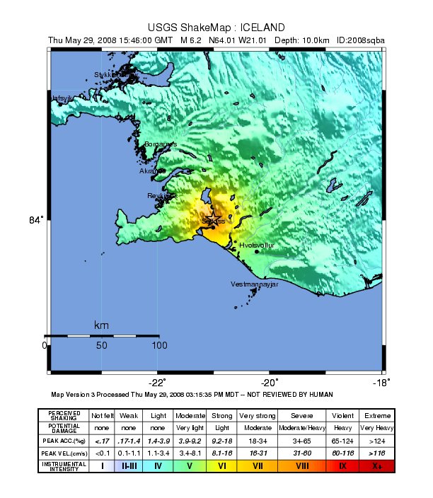
magnitude = 6.3 Mwcite web |url=http://neic.usgs.gov/neis/bulletin/neic_sqba.html |title=Magnitude 6.3 - ICELAND REGION |accessdate=2008-06-17 |date=2008-05-29 |publisher=United States Geological Survey ]
depth = 10 km (6.2 miles)
location = 63.992°N, 21.014°W
countries affected = flagcountry|Iceland
casualties = 30 injuriesThe 2008 Iceland earthquake, magnitude 6.3, struck on
May 29 ,2008 at 15:46UTC . There were no human fatalities, but 30 injuries were reported and a number of sheep were killed. The epicenter of the earthquake was between the towns ofHveragerði and Selfoss, about 45 kilometers (30 miles) east-southeast of the capital,Reykjavík . It was the strongest earthquake to hit Iceland since the summer of 2000. [cite news |url=http://news.bbc.co.uk/2/hi/europe/7426369.stm |title=Strong earthquake rocks Iceland |accessdate=2008-05-29 |date=2008-05-29 |publisher=BBC News ]Characteristics
Iceland straddles the
mid-Atlantic ridge where the Eurasian and North-Americantectonic plate s move away from each other. Volcanic activity is common along such divergent boundaries but strong earthquakes are rare. In Iceland the ridge is somewhat off-set, creating twotransform fault s where plates move horizontally along each other. One is in the north of the country and one in the south, the strongest Icelandic earthquakes happen along those transform faults. The 29 May quakes are classified by geologists as typical "Suðurlandsskjálftar" (literally: Southern Iceland quakes) which happen on the southern fault.
=DaUnlike the quakes in the summer of 2000, the 29 May quake happened in the most densely populated part of the South Iceland district. The population of the affected area is about 12,000 and it includes the towns of
Selfoss andHveragerði as well asEyrarbakki ,Stokkseyri andÞorlákshöfn . Many farms were also affected.ee also
*
2000 Iceland earthquake
*Geology of Iceland
*List of earthquakes References
Wikimedia Foundation. 2010.