North Greenland Ice Core Project

North Greenland Ice Core Project
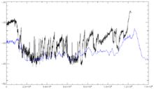
Delta-O-18 record from the NGRIP core

The drilling site of the North Greenland Ice Core Project (NGRIP or NorthGRIP) is near the center of Greenland (75.1 N, 42.32 W, 2917 m, ice thickness 3085). Drilling began in 1999 and was completed at bedrock in 2003 [1]. The cores are cylinders of ice four inches in diameter that were brought to the surface in 3.5-meter lengths. The NGRIP site was chosen to extract a long and undisturbed record stretching into the last glacial, and it succeeded. The site was chosen for a flat basal topography to avoid the flow distortions that render the bottom of the GRIP and GISP cores unreliable. Unusually, there is melting at the bottom of the NGRIP core - believed to be due to a high geothermal heat flux locally. This has the advantage that the bottom layers are less compressed by thinning than they would otherwise be: NGRIP annual layers at 105 kyr age are 1.1 cm thick, twice the GRIP thicknesses at equal age.

The NGRIP record helps to resolve a problem with the GRIP and GISP2 records - the unreliability of the Eemian Stage portion of the record. NGRIP covers 5 kyr of the Eemian, and shows that temperatures then were roughly as stable as the pre-industrial Holocene temperatures were. This is confirmed by sediment cores, in particular MD95-2042 [2].

In 2003, NGRIP recovered what seem to be plant remnants nearly two miles below the surface, and they may be several million years old. [3]

"Several of the pieces look very much like blades of grass or pine needles," said University of Colorado at Boulder geological sciences Professor James White, an NGRIP principal investigator. "If confirmed, this will be the first organic material ever recovered from a deep ice-core drilling project," he said.

External links

The original web page of the NGRIP project with field diaries and pictures. The page has not been updated since the drilling was completed:

The NGRIP project was run by an international consortium of scientists, and drilling and logistics were managed by what is now called Centre for Ice and Climate at the Niels Bohr Institute, University of Copenhagen, Denmark. This research centre maintains a web page about ice core research:

Coordinates: 75°01′N 42°32′W / 75.017°N 42.533°W / 75.017; -42.533


Wikimedia Foundation. 2010.

Игры ⚽ Нужно сделать НИР?

Look at other dictionaries:

  • Greenland Ice Sheet Project — The Greenland Ice Sheet Project (GISP) was a decade long project to drill ice cores in Greenland that involved scientists and funding agencies from Denmark, Switzerland and the United States. Besides the U.S. National Science Foundation, funding… …   Wikipedia

  • Ice core — An ice core is a core sample from the accumulation of snow and ice over many years that have re crystallized and have trapped air bubbles from previous time periods. The composition of these ice cores, especially the presence of hydrogen and… …   Wikipedia

  • North America — North American. the northern continent of the Western Hemisphere, extending from Central America to the Arctic Ocean. Highest point, Mt. McKinley, 20,300 ft. (6187 m); lowest, Death Valley, 276 ft. (84 m) below sea level. 400,000,000 including… …   Universalium

  • Greenland — For other uses, see Greenland (disambiguation). Greenland Kalaallit Nunaat (Kalaallisut) Grønland (Danish) …   Wikipedia

  • Little Ice Age — The reconstructed depth of the Little Ice Age varies between different studies (anomalies shown are from the 1950–80 reference period). The Little Ice Age (LIA) was a period of cooling that occurred after the Medieval Warm Period (Medieval… …   Wikipedia

  • Dye 3 — is an ice core site and previously part of the Distant Early Warning (DEW) line, located at (65°11′N 43°49′W / 65.183°N 43.817°W / 65.183; 43.817 ( …   Wikipedia

  • Arctic Regions — ▪ 2009 The Arctic regions may be defined in physical terms (astronomical [north of the Arctic Circle, latitude 66° 30′ N], climatic [above the 10 °C (50 °F) July isotherm], or vegetational [above the northern limit of the tree line]) or in human… …   Universalium

  • Pleistocene — The Pleistocene (IPAEng| plaɪstəsi:n) is the epoch from 1.8 million to 10,000 years BP covering the world s recent period of repeated glaciations. The name pleistocene is derived from the Greek Polytonic|πλεῖστος ( pleistos most ) and… …   Wikipedia

  • Eem-Interglazial — Die Eem Warmzeit (Synonym Eem Interglazial), oft kurz als Eem oder im Alpenraum auch als Riß/Würm Interglazial benannt, war die letzte Warmzeit vor der heutigen, dem Holozän. Sie begann vor etwa 126.000 Jahren und endete vor 115.000 Jahren und… …   Deutsch Wikipedia

  • Eiskerndatierung — Eisbohrkern wird aus dem Hohlkernbohrer entnommen Durch die Analyse von Eisbohrkernen ist es möglich, Informationen über das Klima der Vergangenheit zu erhalten. Diese Art der Klimadatenerfassung ist eine sehr junge aber zugleich eine der… …   Deutsch Wikipedia

Share the article and excerpts

Direct link
Do a right-click on the link above
and select “Copy Link”