Nanoose Bay, British Columbia

Nanoose Bay, British Columbia
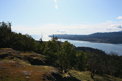
View of Nanoose Bay from Notch Hill

Nanoose Bay is a community of about 5 000 people in the Canadian province of British Columbia. It is located between Nanaimo and Parksville on the Strait of Georgia on the east coast of Vancouver Island. The town is named after a First Nations band related to the Nanaimo Indians. The Schooner Cove Marina with 400 berths is a destination for boaters from throughout the Pacific Northwest.

The Canadian Forces Maritime Experimental Test Range (CFMETR), a joint Canadian-American testing facility for torpedoes and other maritime warfare and listening equipment, has operated out of Nanoose Bay since 1965. There was a protest camp set up along the highway during the 1970s and 1980s protesting the CFMETR.

The ghost town of Red Gap, which was the site of the Straits Lumber Mill from 1912 to 1942, is nearby.

External links

Coordinates: 49°15′N 124°11′W / 49.25°N 124.183°W / 49.25; -124.183


Wikimedia Foundation. 2010.

Игры ⚽ Нужна курсовая?

Look at other dictionaries:

  • Nanoose Bay railway station — Via Rail (inter city rail) Station statistics Address Nanoose Beach Rd. Nanoose Bay, BC V9P 9E6, Canada Lines …   Wikipedia

  • Oak Bay, British Columbia — For the electoral district, see Oak Bay (electoral district). Oak Bay   Municipality   …   Wikipedia

  • Mill Bay, British Columbia — For other places with the same name, see Mill Bay (disambiguation). Mill Bay is a commuter town of about 3,200 people located on Vancouver Island, British Columbia, Canada about 30 km (19 mi) north of Victoria, the capital. Mill Bay was …   Wikipedia

  • Maple Bay, British Columbia — Maple Bay is a picturesque seaside community located in the Cowichan Valley of southern Vancouver Island, British Columbia, Canada. A narrow inlet and surrounded by smooth, pebbled beaches, Maple Bay is home to marine activity all year round. The …   Wikipedia

  • Cowichan Bay, British Columbia — Cowichan Bay (Cow Bay) is a bay and community located near Duncan, in British Columbia. The mouth of the Cowichan River is near Cowichan Bay. The bay is known for its fishing and scenic value. The area s main industries are fishing and tourism.… …   Wikipedia

  • Deep Bay, British Columbia — Aerial view of Deep Bay Marina with Baynes Sound, Denman Island (Chrome Island Light off its tip) and Hornby Island in the background. Deep Bay is an unincorporated area on the east coast of Vancouver Island, in British Columbia, Canada across… …   Wikipedia

  • British Columbia Coast — Howe Sound, along British Columbia s South Coast. The British Columbia Coast or BC Coast is Canada s western continental coastline on the Pacific Ocean. The usage is synonymous with the term West Coast of Canada. In a sense excluding the urban… …   Wikipedia

  • Nanoose Bay — Administration Pays  Canada Province …   Wikipédia en Français

  • Nanoose Bay Forest — Der Nanoose Bay Forest, auch DL33 genannt, ist ein 60 Hektar großes Waldgebiet im Südosten von Vancouver Island, der größten Insel vor der Westküste Kanadas. Es wurde zuletzt um 1920 teilweise abgeholzt, und ist seit 2009, obwohl er ein seltenes… …   Deutsch Wikipedia

  • British Columbia Highway 19 — Infobox road province=BC type=Hwy route=19 maint= length km= length round= length ref= established= direction a= starting terminus= junction= direction b= ending terminus= previous type=Hwy previous route=18 next type=Hwy next route=19AHighway 19 …   Wikipedia

Share the article and excerpts

Direct link
Do a right-click on the link above
and select “Copy Link”