- North Rock Springs, Wyoming
-
North Rock Springs, Wyoming — CDP — Location within the state of Wyoming
 North Rock Springs, Wyoming
Coordinates: 41°38′56″N 109°15′49″W / 41.64889°N 109.26361°WCoordinates: 41°38′56″N 109°15′49″W / 41.64889°N 109.26361°W Country United States State Wyoming County Sweetwater Area – Total 25.5 sq mi (66.0 km2) – Land 25.5 sq mi (65.9 km2) – Water 0.0 sq mi (0.0 km2) Elevation 6,486 ft (1,977 m) Population (2000) – Total 1,974 – Density 77.5/sq mi (29.9/km2) Time zone Mountain (MST) (UTC-7) – Summer (DST) MDT (UTC-6) Area code(s) 307 FIPS code 56-56700[1] GNIS feature ID 1853208[2] North Rock Springs is a census-designated place (CDP) in Sweetwater County, Wyoming, United States. The population was 1,974 at the 2000 census.
Contents
Geography
North Rock Springs is located at 41°38′56″N 109°15′49″W / 41.64889°N 109.26361°W (41.648963, -109.263707)[3].
According to the United States Census Bureau, the CDP has a total area of 25.5 square miles (66.0 km²), of which, 25.5 square miles (65.9 km²) of it is land and 0.04 square miles (0.1 km²) of it (0.08%) is water.
Demographics
As of the census[1] of 2000, there were 1,974 people, 698 households, and 552 families residing in the CDP. The population density was 77.5 people per square mile (29.9/km²). There were 739 housing units at an average density of 29.0/sq mi (11.2/km²). The racial makeup of the CDP was 92.86% White, 0.51% African American, 1.06% Native American, 0.10% Asian, 2.38% from other races, and 3.09% from two or more races. Hispanic or Latino of any race were 7.19% of the population.
There were 698 households out of which 44.4% had children under the age of 18 living with them, 64.9% were married couples living together, 6.7% had a female householder with no husband present, and 20.8% were non-families. 16.5% of all households were made up of individuals and 2.7% had someone living alone who was 65 years of age or older. The average household size was 2.83 and the average family size was 3.18.
In the CDP the population was spread out with 30.6% under the age of 18, 9.7% from 18 to 24, 30.2% from 25 to 44, 25.5% from 45 to 64, and 3.9% who were 65 years of age or older. The median age was 33 years. For every 100 females there were 113.4 males. For every 100 females age 18 and over, there were 110.0 males.
The median income for a household in the CDP was $53,649, and the median income for a family was $55,819. Males had a median income of $45,923 versus $22,450 for females. The per capita income for the CDP was $20,029. About 5.5% of families and 8.0% of the population were below the poverty line, including 9.1% of those under age 18 and none of those age 65 or over.
Education
Public education in the community of North Rock Springs is provided by Sweetwater County School District #1.
References
- ^ a b "American FactFinder". United States Census Bureau. http://factfinder.census.gov. Retrieved 2008-01-31.
- ^ "US Board on Geographic Names". United States Geological Survey. 2007-10-25. http://geonames.usgs.gov. Retrieved 2008-01-31.
- ^ "US Gazetteer files: 2010, 2000, and 1990". United States Census Bureau. 2011-02-12. http://www.census.gov/geo/www/gazetteer/gazette.html. Retrieved 2011-04-23.
Municipalities and communities of Sweetwater County, Wyoming Cities 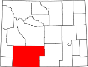
Towns CDPs Arrowhead Springs | Clearview Acres | Eden | Farson | James Town | Little America | McKinnon | North Rock Springs | Point of Rocks | Purple Sage | Reliance | Sweeney Ranch | Washam
Unincorporated
communityGhost towns Bryan | Table Rock | Winton
Categories:- Populated places in Sweetwater County, Wyoming
- Census-designated places in Wyoming


Wikimedia Foundation. 2010.