- Newport Municipal Airport (Arkansas)
-
Newport Municipal Airport
Newport AAF
MCAF Newport
2006 USGS aerial photo IATA: none – ICAO: none – FAA LID: M19 Summary Airport type Public Owner City of Newport Location Newport, Arkansas Elevation AMSL 239 ft / 72 m Coordinates 35°38′25″N 091°10′50″W / 35.64028°N 91.18056°W Runways Direction Length Surface ft m 4/22 5,000 1,524 Asphalt 18/36 5,000 1,524 Asphalt 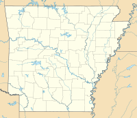
 Newport MAPLocation of Newport Municipal Airport, Arkansas
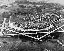 Oblique airphoto of Newport Army Airfield, about 1945, looking east to west.
Newport Municipal Airport (FAA LID: M19) is a general aviation airport located 5 miles NE of Newport, Arkansas.
It is owned and operated by the city of Newport.
Contents
History
Newport was chosen as a site for an Army airfield through the encouragement of Congressman Wilbur D. Mills. The flat land already lent itself to airport usage as most trees had been cleared and the ground had been drained for farming. The project was announced in the middle of May 1942, and construction began almost immediately. Thirty-four farm families were displaced from the main site, along with those living at the auxiliary sites. Construction was rapid given the emergency wartime conditions and within three months the post was to be in full operation. The airfield consisted of four concrete runways 4907x150(N/S), 5004x150(NE/SW), 5000x150(E/W), 5000x150(NW/SE). Also many taxiways, landing aids, and an extended length parking apron. Auxiliary airfields to support the training activities at the base were:
- Amagon (Auxiliary #1) 35°31′59″N 091°03′10″W / 35.53306°N 91.05278°W
- Elgin (Auxiliary #2) 35°46′26″N 091°18′30″W / 35.77389°N 91.30833°W
- Erwin (Auxiliary #3) 35°34′23″N 091°15′15″W / 35.57306°N 91.25417°W
- Milltown (Auxiliary #4) 35°43′55″N 091°06′52″W / 35.73194°N 91.11444°W
- Weldon (Auxiliary #5) Location undetermined, listed as 11 miles ESE of Newport AAF
In addition to the airfield, the building of a large support base with several hundred buildings, numerous streets, a utility network, was carried out with barracks, various administrative buildings, maintenance shops and hangars. The station facility consisted of a large number of buildings based on standardized plans and architectural drawings, with the buildings designed to be the "cheapest, temporary character with structural stability only sufficient to meet the needs of the service which the structure is intended to fulfill during the period of its contemplated war use" was underway. To conserve critical materials, most facilities were constructed of wood, concrete, brick, gypsum board and concrete asbestos. Metal was sparsely used. The station was designed to be nearly self-sufficient, with not only hangars, but barracks, warehouses, hospitals, dental clinics, dining halls, and maintenance shops were needed. There were libraries, social clubs for officers, and enlisted men, and stores to buy living necessities. The buildings, together with complete water, sewer, electric and gas utilities built within a short span.
Newport Army Airfield
The airport was opened in December 1942 as Newport Army Airfield and was used by the United States Army Air Forces as a training base during World War II which conducted training as part of the 70,000 Pilot Training Program. It was assigned to the AAF Flying Training Command, Southeast Training Center (later Eastern Flying Training Command) as a basic (stage 2) pilot training airfield. At its completion, the main airfield site covered some 2,837 acres, while the five auxiliary airstrips totaled 2,447 acres. Its 1943 estimated total value was placed at $10.7 million.
In late November 1942, officers and enlisted personnel began arriving. Cadets followed beginning on January 1, 1943. There were four departments at the base: training, flying, ground school, and link trainer.
These men participated in basic training, chemical warfare training, and many other tactics. The Woman’s Auxiliary Army Corps (WAAC) located at Newport in late May 1943 originally numbered 155 women. While there were no black cadets at Newport, a fairly large number of African Americans served as support staff. Their housing, recreation, and religious facilities were segregated from those of the white population. Instruction at the school consisted of teaching the cadets to fly in formation, fly by instruments or by aerial navigation, fly at night, and fly for long distances. Aviation Cadets who washed out of pilot training were usually sent to navigator or bombardier school. The initial aircraft complement numbered 24 Vultee BT-13 Valiant and BT-15 aircraft. The ten-week course consisted of 70 hours of flight training and 150 hours of ground training.
Four thousand Army pilots received basic training at Newport field from Dec. 25, 1942, to June 21, 1944. Some 425,000 hours were flown during the time. At least twenty-eight deaths occurred from crashes and related incidents at the airfield.
Marine Corps Air Facility Newport
USAAF pilot training ended at Newport, and the United States Marine Corps began to utilize the airfield beginning in May 1944. The field was renamed Marine Corps Air Facility Newport and was home to Marine Aircraft Group 34 (MAG-34) and its SBD Dauntless aircraft and Marine Aircraft Group 62 (MAG-62) and its PBJ squadrons. One of Newport's shortcomings was a lack of local bombing and gunnery ranges, and training ended at the end of August 1945.
About the same time the marines were pulling out of Newport, a German prisoner of war (POW) camp was created at the airfield. Nearly 300 POWs were placed at the camp from the fall of 1945 until January 1946. They were paid for the jobs they performed, from clearing land to harvesting crops. The entire military facility was shuttered by the spring of 1946.
Civil use
After war’s end, the Newport airfield was declared to be government surplus. Eventually, most of the main field was turned over to the City of Newport to be used as an airport facility and industrial park. While many of the base’s buildings were sold off, some were used by civilians who occupied much of the housing. The large hangar-type buildings were all gone by the early 1960s, and there are no longer any military buildings remaining at the airfield. The auxiliary fields were all disposed of. None of the temporary structures built by the USAAF or USMC remain today. The few that survived the war were destroyed by a tornado in 1953.[1]
Several of the runways are still in use, and a new airport terminal was constructed in 1983. A number of industries are located at what is now the Newport Industrial Park. The Jackson County Learning Center has been located at the base since 1959. Some homes from the original residential area are still occupied. Also holding a place of prominence at the former airbase is Arkansas State University–Newport.
See also
Notes
- ^ Shettle, USMC Air Stations of WWII, p.117.
References
 This article incorporates public domain material from websites or documents of the Air Force Historical Research Agency.
- ^ Shettle, USMC Air Stations of WWII, p.117.
- Manning, Thomas A. (2005), History of Air Education and Training Command, 1942–2002. Office of History and Research, Headquarters, AETC, Randolph AFB, Texas ASIN: B000NYX3PC
- Shaw, Frederick J. (2004), Locating Air Force Base Sites History’s Legacy, Air Force History and Museums Program, United States Air Force, Washington DC, 2004.
- Thole, Lou (1999), Forgotten Fields of America : World War II Bases and Training, Then and Now - Vol. 2. Publisher: Pictorial Histories Pub, ISBN 1575100517
- Shettle, M. L., Jr. (2001). United States Marine Corps Air Stations of World War II. Bowersville, Georgia: Schaertel Publishing Co.. ISBN 0-964-33882-3.
External links
- Resources for this airport:
- AirNav airport information for M19
- FlightAware airport information and live flight tracker
- SkyVector aeronautical chart for M19
 Army Air Forces Training Command
Flying Training Flying Schools Eastern Flying Training Command · Central Flying Training Command · Western Flying Training CommandSpecialized Schools Bombardier · Contract Flying · Glider Training · Gunnery · Navigator
Technical Training Eastern Technical Training Command · Central Technical Training Command · Western Technical Training CommandCategories:- Airfields of the United States Army Air Forces in Arkansas
- Defunct United States Marine Corps facilities
- Airports in Arkansas
- World War II airfields
- USAAF Southeast Training Center
- Transportation in Jackson County, Arkansas
- Buildings and structures in Jackson County, Arkansas


Wikimedia Foundation. 2010.