- Mevo Hama
-
Mevo Hama Hebrew מְבוֹא חַמָּה Founded 1968 Council Golan Regional Council Region Golan Heights District North Affiliation Kibbutz Movement Coordinates 32°44′13″N 35°39′18″E / 32.73694°N 35.655°ECoordinates: 32°44′13″N 35°39′18″E / 32.73694°N 35.655°E Population 336 (2006) 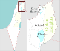
 Mevo Hama
Mevo Hama (Hebrew: מְבוֹא חַמָּה) is an Israeli settlement and a kibbutz, on the southern Golan Heights. The southernmost village in the Golan, it is located 2 kilometers (1.2 mi) from the Sea of Galilee at a height of 350 meters (1,150 ft) above sea level. It falls under the jurisdiction of Golan Regional Council. The international community considers Israeli settlements in the Golan Heights illegal under international law, but the Israeli government disputes this.[1]
History
The second Israeli settlement established in the Golan after the 1967 Six-Day War, it was built on a Syrian military base called "Emrit Ez Edeen", from which the Syrians had fired at the kibbutzim on the border (Ein Gev and HaOn). In January 1968, several members of the surrounding kibbutzim gathered and decided to establish a new settlement in the area and in September had settled the ruins of the base. They were joined in In 1971 by several youth groups from Israel, Australia and England. The name of the settlement, meaning The Source of the Hot Springs, was given to it by author Mattityahu Shalem.
See also
References
- ^ "The Geneva Convention". BBC. 10 December 2009. http://news.bbc.co.uk/2/hi/middle_east/1682640.stm.
Moshavim Alonei HaBashan · Aniam · Avnei Eitan · Bnei Yehuda · Eliad · Givat Yoav · Haspin · Kanaf · Keshet · Kidmat Tzvi · Ma'ale Gamla · Neot Golan · Neve Ativ · Nimrod · Nov · Odem · Ramat Magshimim · Ramot · Sha'al · YonatanCommunal settlements Kela Alon · Had NesCategories:- Israel geography stubs
- Kibbutzim
- Kibbutz Movement
- Populated places established in 1968
- Golan Regional Council
- Israeli settlements

Wikimedia Foundation. 2010.