Aldford Iron Bridge

Aldford Iron Bridge

Infobox_Bridge
bridge_name=Aldford Iron Bridge


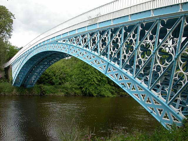
caption=Aldford Iron Bridge
official_name=
carries=
crosses=River Dee
locale=Aldford, Cheshire
maint=
id=
design= Arch bridge
material= Iron
mainspan=
length=
width=
height=
load=
clearance=
below=
traffic=
open=1824
closed=
toll=None
troll=
map_cue=
map_

map_text=
map_width=
coordinates= coord|53.1347|-2.870822|type:landmark_scale:2000_region:GB
lat=53.1347
long=-2.870822

Aldford Iron Bridge is a bridge crossing the River Dee north of the village of Aldford, Cheshire, England, linking the village with Eaton Hall, forming part of the Buerton Approach to the hall (gbmapping|SJ418601). It is a Grade I listed building.cite web |url=http://www.imagesofengland.org.uk/search/details.aspx?pid=1&id=55196 |title=Images of England: Iron Bridge over the River Dee, Aldford |accessdate=2008-03-28 |publisher=English Heritage ]

The bridge was built in 1824 by William Hazledine for the 1st Marquis of Westminster. It is built in cast iron and has yellow sandstone abutments forming a single arch measuring 50 metres. It has cast iron railings and double gates at the crown of the bridge.

The bridge provides a crossing over the river for the long-distance footpath of the Marches Way. ["Wirral & Chester:Explorer 266 map", Ordnance Survey.]

Notes


Wikimedia Foundation. 2010.

Игры ⚽ Поможем сделать НИР

Look at other dictionaries:

  • Aldford — infobox UK place country = England static static image caption= latitude= 53.126 longitude= 2.866 official name =Aldford population = civil parish=Aldford shire district= Chester shire county= Cheshire region= North West England constituency… …   Wikipedia

  • Liste de ponts du Royaume-Uni — Cette liste de ponts du Royaume Uni recense les ponts les plus remarquables du fait de leurs caractéristiques dimensionnelles ou de leur intérêt architectural ou historique en Angleterre, en Écosse, au Pays de Galles et en Irlande du nord. Les… …   Wikipédia en Français

  • Liste der Grade-I-Baudenkmäler in Cheshire — Die Liste der Grade I Bauwerke in Cheshire verzeichnet die Listed Buildings in Cheshire, etwa 80 Einträge, von denen die rund die Hälfte Kirchenbauten sind, mit Ausnahme derjenigen in Chester, die aus der Liste der Grade I Baudenkmäler in Chester …   Deutsch Wikipedia

  • Civil parishes in Cheshire — A map of Cheshire, showing the Boroughs : (1) Cheshire West and Chester; (2) Cheshire East; (3) Warrington; and (4) Halton. A civil parish is a subnational entity, forming the lowest unit of local government in England. There are 332 civil… …   Wikipedia

  • List of Grade I listed buildings in Cheshire — There are over 6000 Grade I listed buildings in England. This page is a list of these buildings in the county of Cheshire, sub divided by district.Chester* Iron Bridge, Aldford * Beeston Castle: walls of outer bailey * Beeston Castle: walls,… …   Wikipedia

  • John Douglas (architect) — For other people of the same name, see John Douglas (disambiguation). John Douglas John Douglas, photograph published in 1890 Born 11 April 1830(1830 04 11) Sandiway …   Wikipedia

  • Chester — For the larger local government district, see Cheshire West and Chester. For other uses, see Chester (disambiguation). Coordinates: 53°11′33″N 2°53′30″W / 53.192 …   Wikipedia

  • Thomas Brassey — This article is about the civil engineering contractor. For his son of the same name, see Thomas Brassey, 1st Earl Brassey. Thomas Brassey Thomas Brassey in 1830 Born 7 November 1805 Buerton, Cheshir …   Wikipedia

  • No Man's Heath, Cheshire — Coordinates: 53°01′36″N 2°43′26″W / 53.0266°N 2.7238°W / 53.0266; 02.7238 …   Wikipedia

  • Mickle Trafford — Coordinates: 53°13′16″N 2°49′59″W / 53.22101°N 2.83293°W / 53.22101; 2.83293 …   Wikipedia

Share the article and excerpts

Direct link
Do a right-click on the link above
and select “Copy Link”