Mount Meeker

Mount Meeker
Mount Meeker

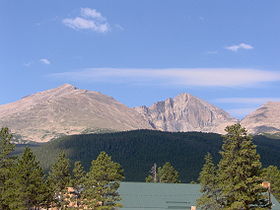
Western side of Mount Meeker (left), with Longs Peak immediately to the right.
Elevation 13,911 ft (4,240 m) NGVD 29[1]
Prominence 431 ft (131 m) [1]
Location
Location Rocky Mountain National Park, Boulder County, Colorado, USA
Range Front Range
Coordinates 40°14′55″N 105°36′18″W / 40.2485958°N 105.6050027°W / 40.2485958; -105.6050027Coordinates: 40°14′55″N 105°36′18″W / 40.2485958°N 105.6050027°W / 40.2485958; -105.6050027[2]
Topo map Allenspark, CO

Mount Meeker is a high mountain peak in northern Colorado, located in the southern part of Rocky Mountain National Park. The elevation is 13,911 feet (4,240 m). It is the second highest mountain in Rocky Mountain National Park. The peak is a prominent figure along the northern Front Range of Colorado. The peak is easily visible from the Denver area, especially in the northern suburbs of Broomfield, Longmont, and Loveland. Due to its location in relation to Longs Peak, Mount Meeker is actually more prominent along the Front Range. The peak is considered harder, technically, than Longs Peak.

See also

References

External links


Wikimedia Foundation. 2010.

Игры ⚽ Поможем сделать НИР

Look at other dictionaries:

  • Mount Vernon, Iowa —   City   Location of Mount Vern …   Wikipedia

  • Nathan Meeker — Nathanial C. Meeker Born July 12, 1817(1817 07 12) Euclid, Ohio Died September 30, 1879(1879 09 30) (aged 6 …   Wikipedia

  • List of mountains of the United States — This list of mountains of the United States includes significant mountain peaks and high points located in the United States of America arranged alphabetically by state, district, or territory.ignificant mountain peaks and high points Alabama… …   Wikipedia

  • Longs Peak — Infobox Mountain Name = Longs Peak Photo = Fall05 LongsPeakCU JPG RSZ md.jpg Caption= East face of Longs Peak Elevation = 14,259 feet (4,346 m) Location = Colorado, USA Range = Front Range Prominence = 9,822 ft (2,994 m) Coordinates =… …   Wikipedia

  • Rocky Mountain National Park — Infobox Protected area name = Rocky Mountain National Park iucn category = II nrhp type = hd | caption = locator x = 96 locator y = 78 location = Larimer, Grand, Boulder counties, Colorado, USA nearest city = Estes Park coords =… …   Wikipedia

  • Twin Peaks (disambiguation) — Twin Peaks can refer to:Mountains*Twin Peaks (San Francisco), two 920 foot (280m) high hills in San Francisco and the surrounding neighborhood *North Twin Peak and South Twin Peak in the Canadian Rockies *Twin Peaks, referring to Longs Peak and… …   Wikipedia

  • Chapel on the Rock — Coordinates: 40°14′49″N 105°32′08″W / 40.246933°N 105.535676°W / 40.246933; 105.535676 …   Wikipedia

  • National Register of Historic Places listings in Pierce County, Washington — Map of all coordinates from Google Map of all coordinates from Bing …   Wikipedia

  • List of townships in Minnesota (A-M) — The U.S. state of Minnesota is divided into 2,775 townships in 87 counties. Index: compactTOC A*Aastad Township, Otter Tail County *Acoma Township, McLeod County *Acton Township, Meeker County *Adams Township, Mower County *Adrian Township,… …   Wikipedia

  • Oregon Trail — For other uses, see Oregon Trail (disambiguation). Oregon Trail The route of the Oregon Trail shown on a map of the western United States from Independence, Missouri (on the eastern end) to Oregon City, Oregon (on the western end) …   Wikipedia

Share the article and excerpts

Direct link
Do a right-click on the link above
and select “Copy Link”