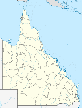
- Ceratodus, Queensland
-
Ceratodus (
 /sɛrəˈtoʊdəs/)[1] is a settlement in Queensland, Australia on the Burnett River about 8.8 kilometres (5.5 mi) from Eidsvold, Queensland.
History
The name Ceratodus was given to the settlement about 1922 [2] and derives from that of the Queensland lungfish, neoceratodus forsteri. A railway station opened here 26 April 1924.[3] On 12 September 1924, the District Postal Inspector, Maryborough Division, reported that 100 railway employees were camped at Ceratodus, engaged on bridge building and other railway work, and that there was one permanent settler (named Falconer) in the locality.[4]
A receiving office opened at the railway station in January 1925[4] and was elevated to a post office by April 1926.[3] The settlement was, for many years, a watering station for steam locomotives. In 1967 it was reported that the postmistress and station-mistress (Mrs J. Leard) also operated the telephone exchange (to which only one subscriber's service was connected) and that there were no shops or businesses in the settlement, only two railway cottages.[4] The post office closed 31 May 1968.[3]
References
- ^ Macquarie Dictionary, Fourth Edition (2005). Melbourne, The Macquarie Library Pty Ltd. ISBN 1-876429-14-3
- ^ Memoirs of the Queensland Museum, Vol ix, 1928
- ^ a b c Frew, Joan (1981) Queensland Post Offices 1842-1980 and Receiving Offices 1869-1927, p. 231. Fortitude Valley, Queensland: published by the author, ISBN 0-9593973-0-2
- ^ a b c King, Harold J., in Stamp Collecting (London), 25 August 1967
Towns and communities in the North Burnett Region | Wide Bay-Burnett | Queensland Abercorn · Ban Ban Springs · Biggenden · Binjour · Byrnestown · Ceratodus · Coulston Lakes · Dallarnil · Degilbo · Didcot · Eidsvold · Gayndah · Gooroolba · Humphery · Ideraway · Kalpowar · Moonford · Monto · Mount Perry · Mulgildie · Mundubbera · Mungungo
Main Article: Local Government Areas of QueenslandCategories:- Towns in Queensland
- Queensland geography stubs
Wikimedia Foundation. 2010.

