- Keystone, South Dakota
Infobox Settlement
official_name = Keystone, South Dakota
other_name =
native_name =
nickname =
settlement_type =Town
motto =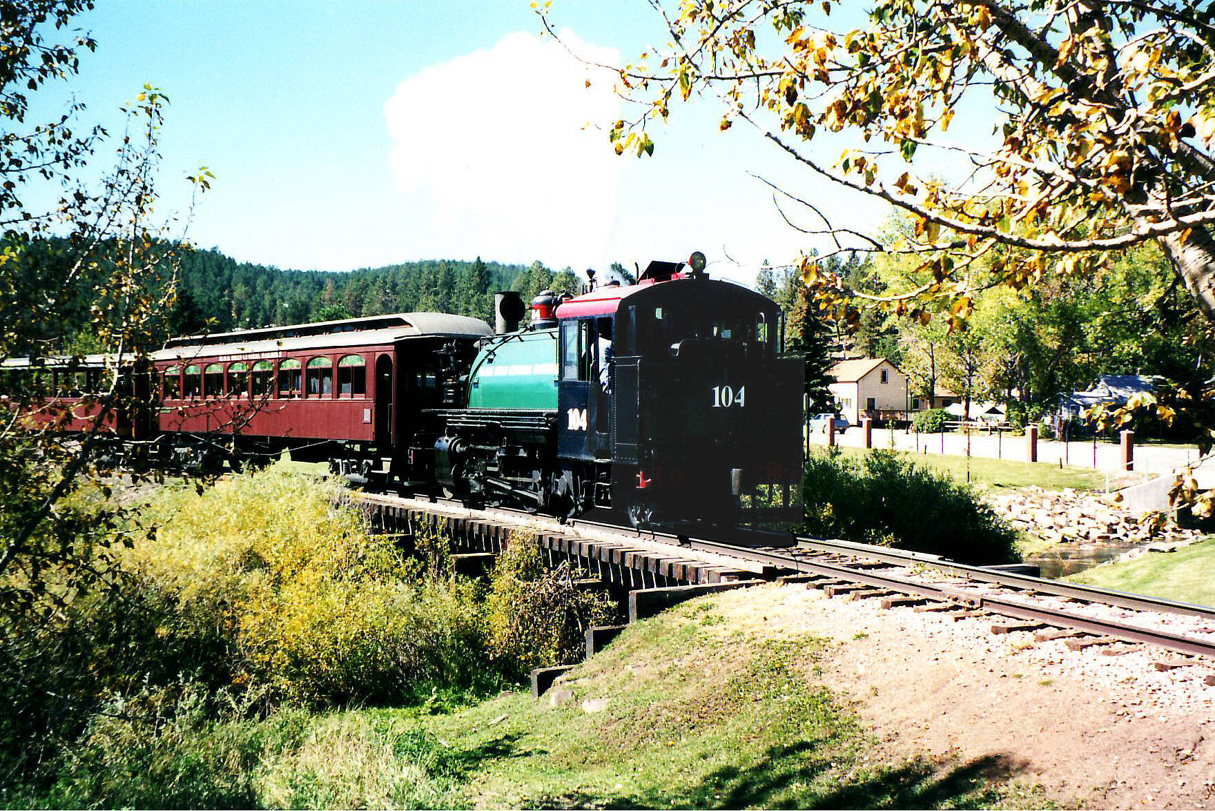
imagesize = 300px
image_caption = ABlack Hills Central Railroad train steams out of Keystone in 2001. This section of trackage was damaged by a flood which hit Keystone in 1972
flag_size =
image_
seal_size =
image_shield =
shield_size =
image_blank_emblem =
blank_emblem_type =
blank_emblem_size =
flag_size =
image_
seal_size =
image_shield =
shield_size =
image_blank_emblem =
blank_emblem_type =
blank_emblem_size =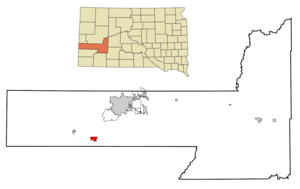
mapsize = 250px
map_caption = Location in Pennington County and the state ofSouth Dakota
mapsize1 =
map_caption1 =
image_dot_
dot_mapsize =
dot_map_caption =
dot_x =
dot_y =
pushpin_
pushpin_label_position =
pushpin_map_caption =
pushpin_mapsize =
subdivision_type = Country
subdivision_name =United States
subdivision_type1 = State
subdivision_name1 =South Dakota
subdivision_type2 = County
subdivision_name2 = Pennington
subdivision_type3 =
subdivision_name3 =
subdivision_type4 =
subdivision_name4 =
government_footnotes =
government_type =
leader_title =
leader_name =
leader_title1 =
leader_name1 =
leader_title2 =
leader_name2 =
leader_title3 =
leader_name3 =
leader_title4 =
leader_name4 =
established_title =
established_date =
established_title2 =
established_date2 =
established_title3 =
established_date3 =
area_magnitude =
unit_pref = Imperial
area_footnotes =
area_total_km2 = 7.4
area_land_km2 = 7.4
area_water_km2 = 0
area_total_sq_mi = 2.9
area_land_sq_mi = 2.9
area_water_sq_mi = 0
area_water_percent =
area_urban_km2 =
area_urban_sq_mi =
area_metro_km2 =
area_metro_sq_mi =
area_blank1_title =
area_blank1_km2 =
area_blank1_sq_mi =
population_as_of = 2000
population_footnotes =
population_note =
population_total = 311
population_density_km2 = 42
population_density_sq_mi = 107.2
population_metro =
population_density_metro_km2 =
population_density_metro_sq_mi =
population_urban =
population_density_urban_km2 =
population_density_urban_sq_mi =
population_blank1_title =
population_blank1 =
population_density_blank1_km2 =
population_density_blank1_sq_mi =
timezone = Mountain (MST)
utc_offset = -7
timezone_DST = MDT
utc_offset_DST = -6
latd = 43 |latm = 53 |lats = 37 |latNS = N
longd = 103 |longm = 25 |longs = 34 |longEW = W
elevation_footnotes =
elevation_m = 1320
elevation_ft = 4331
postal_code_type =ZIP code
postal_code = 57751
area_code = 605
blank_name = FIPS code
blank_info = 46-33820GR|2
blank1_name = GNIS feature ID
blank1_info = 1261912GR|3
website =
footnotes =Keystone is a town in the
Black Hills region of Pennington County,South Dakota ,United States . The population was 311 at the 2000 census. It had its origins in 1883 as a mining town, and has since transformed itself into a resort town, serving the needs of the millions of visitors toMount Rushmore National Memorial , which is located just beyond city limits.Among its tourist attractions is the
Black Hills Central Railroad , built in 1900 forBlack Hills gold. It now operates passenger trains pulled by preservedsteam locomotive s.Carrie Ingalls "("Little House on the Prairie ")" spent a significant part of her adult life here, living with her husband David N. Swanzey and his children. Her sisterMary Ingalls lived with them for a while and died here in 1928.Geography
Keystone is located at coor dms|43|53|37|N|103|25|34|W|city (43.893744, -103.426080)GR|1.
According to the
United States Census Bureau , the town has a total area of 2.9square mile s (7.4km² ), all of it land.Keystone has been assigned the
ZIP code 57751 and theFIPS place code 33820.Demographics
As of the
census GR|2 of 2000, there were 311 people, 152 households, and 84 families residing in the town. Thepopulation density was 108.6 people per square mile (42.0/km²). There were 209 housing units at an average density of 73.0/sq mi (28.2/km²). The racial makeup of the town was 95.50% White, 1.93% Native American, 0.32% from other races, and 2.25% from two or more races. Hispanic or Latino of any race were 3.54% of the population.There were 152 households out of which 27.0% had children under the age of 18 living with them, 37.5% were married couples living together, 12.5% had a female householder with no husband present, and 44.1% were non-families. 35.5% of all households were made up of individuals and 11.8% had someone living alone who was 65 years of age or older. The average household size was 2.05 and the average family size was 2.60.
In the town the population was spread out with 20.9% under the age of 18, 5.8% from 18 to 24, 30.9% from 25 to 44, 30.9% from 45 to 64, and 11.6% who were 65 years of age or older. The median age was 41 years. For every 100 females there were 89.6 males. For every 100 females age 18 and over, there were 95.2 males.
The median income for a household in the town was $26,406, and the median income for a family was $36,250. Males had a median income of $24,219 versus $17,500 for females. The
per capita income for the town was $15,828. About 13.9% of families and 16.9% of the population were below thepoverty line , including 17.9% of those under age 18 and 23.3% of those age 65 or over.References
External links
Wikimedia Foundation. 2010.