- Nisland, South Dakota
-
Nisland, South Dakota — Town — Location in Butte County and the state of South Dakota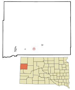
Coordinates: 44°40′25″N 103°33′11″W / 44.67361°N 103.55306°WCoordinates: 44°40′25″N 103°33′11″W / 44.67361°N 103.55306°W Country United States State South Dakota County Butte Platted 1909[1] Area – Total 0.3 sq mi (0.7 km2) – Land 0.3 sq mi (0.7 km2) – Water 0 sq mi (0 km2) Elevation 2,854 ft (870 m) Population (2010) – Total 232 – Density 773.3/sq mi (331.4/km2) Time zone Mountain (MST) (UTC-7) – Summer (DST) MDT (UTC-6) ZIP code 57762 Area code(s) 605 FIPS code 46-45180[2] GNIS feature ID 1256710[3] Nisland is a town in Butte County, South Dakota, United States. The population was 232 at the 2010 census.
Geography
Nisland is located at 44°40′25″N 103°33′11″W / 44.67361°N 103.55306°W (44.673487, -103.552950).[4]
According to the United States Census Bureau, the town has a total area of 0.2 square miles (0.52 km2), all of it land.
Nisland has been assigned the ZIP code 57762 and the FIPS place code 45100.
Demographics
As of the census[2] of 2000, there were 204 people, 80 households, and 58 families residing in the town. The population density was 800.7 people per square mile (315.1/km²). There were 100 housing units at an average density of 392.5 per square mile (154.4/km²). The racial makeup of the town was 82.84% White, 9.80% Native American, 5.88% from other races, and 1.47% from two or more races. Hispanic or Latino of any race were 6.86% of the population.
There were 80 households out of which 37.5% had children under the age of 18 living with them, 45.0% were married couples living together, 15.0% had a female householder with no husband present, and 27.5% were non-families. 27.5% of all households were made up of individuals and 11.3% had someone living alone who was 65 years of age or older. The average household size was 2.55 and the average family size was 2.93.
In the town the population was spread out with 29.9% under the age of 18, 8.8% from 18 to 24, 21.6% from 25 to 44, 22.1% from 45 to 64, and 17.6% who were 65 years of age or older. The median age was 38 years. For every 100 females there were 100.0 males. For every 100 females age 18 and over, there were 116.7 males.
The median income for a household in the town was $19,063, and the median income for a family was $19,844. Males had a median income of $19,886 versus $13,958 for females. The per capita income for the town was $10,017. About 28.6% of families and 26.9% of the population were below the poverty line, including 50.0% of those under the age of eighteen and none of those sixty five or over.
References
- ^ "SD Towns". South Dakota State Historical Society. http://history.sd.gov/Archives/forms/exhibits/SD%20Towns.pdf. Retrieved 2010-02-14.
- ^ a b "American FactFinder". United States Census Bureau. http://factfinder.census.gov. Retrieved 2008-01-31.
- ^ "US Board on Geographic Names". United States Geological Survey. 2007-10-25. http://geonames.usgs.gov. Retrieved 2008-01-31.
- ^ "US Gazetteer files: 2010, 2000, and 1990". United States Census Bureau. 2011-02-12. http://www.census.gov/geo/www/gazetteer/gazette.html. Retrieved 2011-04-23.
Municipalities and communities of Butte County, South Dakota Cities 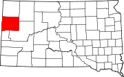
Towns Fruitdale | Nisland
Townships Unorganized
territoriesEast Butte | West Butte
Unincorporated
communitiesCategories:- Towns in South Dakota
- Populated places in Butte County, South Dakota


Wikimedia Foundation. 2010.