- Crast' Agüzza
-
Crast' Agüzza 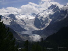
Crast' Agüzza (small rocky peak in centre) and Piz Bernina (right)Elevation 3,869 m (12,694 ft) Translation Pointed peak Location 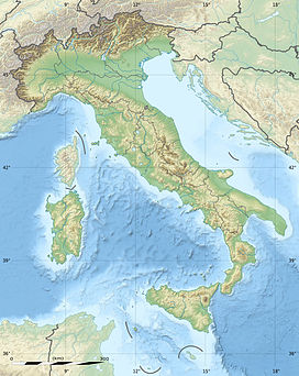
 Crast' Agüzza
 Italy /
  Switzerland
Range Bernina Range Coordinates 46°22′50″N 9°54′25″E / 46.38056°N 9.90694°ECoordinates: 46°22′50″N 9°54′25″E / 46.38056°N 9.90694°E Geology Type Granite Climbing First ascent 17 July 1865 by Johann Jakob Weilenmann, J. A. Specht, Franz Pöll and Jakob Pfitschner via west ridge Easiest route East ridge–west ridge traverse from Marco e Rosa Hut (PD+) Crast' Agüzza (known also as Cresta Güzza) (3,869 m) is a mountain in the Bernina Range in Italy and Switzerland.
The peak is bounded to the north by the Morteratsch Glacier and to the south by the Upper Scerscen Glacier. To its immediate north-west lies the Fuorcla Crast' Agüzza (3,601 m); according to Collomb, this is 'the most important glacier pass across the central Bernina Alps; comparable in position with Col du Géant in the Mont Blanc range.'[1] The first party to reach the pass (from the north) comprised E. S. Kennedy and J. F. Hardy, with guides Peter and F. Jenny and A. Flury, on 23 July 1861. The first party to travese the col comprised Francis Fox Tuckett and E. N. Buxton together with guides Peter Jenny, Christian Michel and Franz Biner on 28 July 1864.[2]
The usual ascent is made via the rocky east ridge from the Fuorcla da l'Argient. This route was first ascended by Emil Burckhardt with Hans Grass and Peter Egger in August 1874.[3]
The mountain is known locally as the Engadin Matterhorn.[1]
Huts
- Marco e Rosa Hut (3,597 m)
References
External links
Categories:- Bernina Range
- Engadin
- Mountains of the Alps
- Alpine Three-thousanders
- Mountains of Italy
- Mountains of Switzerland
- Italy–Switzerland border
- International mountains of Europe


Wikimedia Foundation. 2010.