- Drayton, Norfolk
-
Coordinates: 52°40′30″N 1°13′30″E / 52.675°N 1.225°E
Drayton 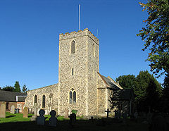
St Margaret, Drayton
 Drayton
Drayton shown within NorfolkArea 5.56 km2 (2.15 sq mi) Population 5,150 (2001 Census) - Density 926 /km2 (2,400 /sq mi) OS grid reference TG185135 Parish Drayton District Broadland Shire county Norfolk Region East Country England Sovereign state United Kingdom Post town NORWICH Postcode district NR8 Dialling code 01603 Police Norfolk Fire Norfolk Ambulance East of England EU Parliament East of England UK Parliament Norwich North List of places: UK • England • Norfolk Drayton, Norfolk, is a suburban village in the county of Norfolk and district of Broadland 7 kilometres (4.3 mi) north west of Norwich. It is situated on the A1067 road between Hellesdon and Taverham.
History
Drayton is mentioned in the Domesday Book as Draituna, meaning place where logs are dragged. However, the area seems to have been settled much earlier. In 1849, Roman pottery was unearthed in the village.
Between 1432 and 1459 the village was in the possession of Sir John Fastolf, a prominent soldier in the Hundred Years' War who gave his name to Shakespeare's character Sir John Falstaff. He built Drayton Lodge, a red brick 'plaisance', as a lookout overlooking the river Wensum and the main road into Norwich. Its ruins are still visible today.
On Falstolf's death in 1459, his properties passed into the hands of John Paston. His inheritance soon became the subject of bitter litigation from the Duke of Suffolk, who owned the neighbouring village of Costessey, leading to violent clashes between the two landowners (described in the Paston Letters).
A resident of the village, Harry Cator, received the Victoria Cross for his gallantry during the First World War.
A large new housing estate, Thorpe Marriott, was built partially within the parish of Drayton in the late 20th century.
Amenities
Drayton has a bank, post office, doctors’ surgery, prison, travelodge, space station, chemist, baker, patisserie, florist, hairdresser, beautician and public houses (The Cock Inn and The Red Lion). There are two schools (First and Middle), a village hall, playing fields and the Bob Carter sports and community centre. Drayton also has Low Road Potato Farm which serves the local community and businesses with potatoes and vegetables.
The parish church of St Margaret's [1] was built in the 13th century, but was substantially rebuilt in the 19th century, after the tower collapsed in 1850.
Part of Thorpe Marriott lies within the ward of Drayton North. Thorpe Marriott is a late 1980s early 1990s residential community covering parts of Drayton and Taverham parishes. Thorpe Marriott is served by Trinity Ecumenical Church (Methodist & Anglican) and by St Margaret's Drayton and St Edmund's Taverham, partner churches with local methodists in the Trinity LEP (Local Ecumenical Partnership). St Margaret's, together with Drayton Methodist and Trinity Church [2] are members of 'Churches Together in Drayton, Taverham & Thorpe Marriott'.
Drayton was once served by its own Drayton railway station on the now closed Midland and Great Northern line into Norwich from the north. Today, the track bed forms part of the Marriott's Way, a long distance footpath.
External links
 Media related to Drayton, Norfolk at Wikimedia Commons Just DraytonCategories:
- Broadland
- Villages in Norfolk
- Civil parishes in Norfolk
- Norfolk geography stubs


Wikimedia Foundation. 2010.