- MetroCentre railway station
-
MetroCentre 
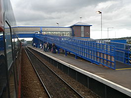
MetroCentre railway station viewed from a GNER intercity service diverted via the Tyne Valley Line in October 2005 Location Place Dunston Local authority Gateshead Operations Station code MCE Managed by Northern Rail Number of platforms 2 Live arrivals/departures and station information
from National Rail EnquiriesAnnual rail passenger usage 2004/05 * 376,000 2005/06 *  376,000
2006/07 *  373,000
2007/08 *  384,000
2008/09 * 381,0002009/10 * 373,000Passenger Transport Executive PTE Tyne and Wear (Nexus) Zone 25 History Opened 2 August 1987 as Gateshead Metro Centre History 1993 Name changed to MetroCentre National Rail - UK railway stations A B C D E F G H I J K L M N O P Q R S T U V W X Y Z * Annual passenger usage based on sales of tickets in stated financial year(s) which end or originate at MetroCentre from Office of Rail Regulation statistics. Please note: methodology may vary year on year. MetroCentre railway station is a railway station that serves the MetroCentre shopping and leisure complex in Gateshead, Tyne and Wear. It is located on the Tyne Valley Line from Newcastle upon Tyne to Carlisle, and is managed by Northern Rail.
The station opened on 3 August 1987. It is an unmanned station, connected to the MetroCentre mall by a covered footbridge. Initially called Gateshead MetroCentre, the station's name was shortened to MetroCentre from 17 May 1993.
There is a regular shuttle service to Newcastle Central station, a half-hourly service to Hexham and hourly extensions through to Carlisle. Additionally, many trains run beyond Newcastle to Sunderland, Middlesbrough or Morpeth.
Most train services are operated by Northern Rail; however the station is also served by First ScotRail, which operates a few daily services to Glasgow via Carlisle.
The station is covered by a Ditra Systems Public Address System (PA), voiced by Phil Sayer.
External links
- Train times and station information for MetroCentre railway station from National Rail
- Buses from the station
- Buses to the station
Preceding station  National Rail
Following station Newcastle First ScotRail
Wylam Dunston
Newcastle on SundaysNorthern Rail
Tyne Valley LineBlaydon
Wylam on SundaysEast Coast Main Line (London Kings Cross) → → Birtley (closed) • Lamesley (closed) • Low Fell (closed) • Bensham (closed) • Newcastle Central • Manors • Heaton (closed) • Forest Hall (closed) • Killingworth (closed) • Annitsford (closed) → →(Edinburgh Waverley)Durham Coast Line Tyne Valley Line Former railway linesBlyth and Tyne Railway Backworth • Benton • Cullercoats • Gosforth • Holywell • Jesmond • Moor Edge • New Bridge Street • North Shields • Percy Main • Prospect Hill • Tynemouth • Whitley BayDerwent Valley Railway Swalwell • Rowlands Gill → → (Blackhill)Newcastle and Carlisle Railway
(Original route)North Wylam loop Lemington • Newburn • Heddon on the Wall • North WylamPonteland Light Railway Gosforth • West Gosforth • Coxlodge • Kenton • Callerton → → (Ponteland)Riverside branch Byker • St Peter's (Tyneside) • St Anthony's • Walker • Carville • Point Pleasant • Willington QuayTanfield Railway Sunniside → → (East Tanfield)Metro (converted stations) Benton • Brockley Whins • Cullercoats • East Boldon • Felling • Hebburn • Howdon • Jarrow • Longbenton • Monkseaton • North Shields • Percy Main • Seaburn • South Gosforth • Sunderland • Tynemouth • Walkergate • Wallsend • West Jesmond • West Monkseaton • Whitley Bay •Metro (purpose built stations) Airport • Bank Foot • Bede • Byker • Callerton Parkway • Central Station • Chichester • Chillingham Road • Fawdon • Fellgate • Four Lane Ends • Gateshead • Gateshead Stadium • Hadrian Road • Haymarket • Heworth • Ilford Road • Jesmond Metro station • Kingston Park • Manors • Meadow Well • Millfield • Monument • Northumberland Park • Pallion • Palmersville • Park Lane • Pelaw • Regent Centre • Simonside • St James • St Peter's (Wearside) • Shiremoor • South Hylton • South Shields • Stadium of Light • Tyne Dock • University (Sunderland) • Wansbeck Road •Coordinates: 54°57′32″N 1°39′54″W / 54.958911°N 1.664898°W
Categories:- Railway stations in Tyne and Wear
- Railway stations opened by British Rail
- Railway stations opened in 1987
- Railway stations served by First ScotRail
- Railway stations served by Northern Rail
- Tyne and Wear building and structure stubs
- North East England railway station stubs

Wikimedia Foundation. 2010.