- Ambridge, Pennsylvania
Infobox Settlement
official_name = Pagename
other_name =
native_name =
nickname =
settlement_type =Borough
motto = Home toOld Economy Village 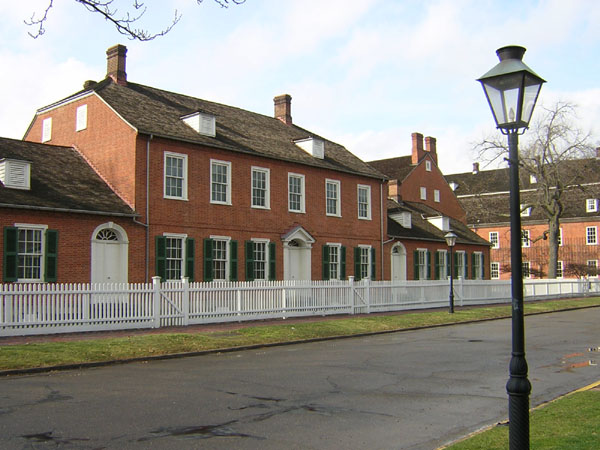
imagesize =
image_caption = The Rapp House inOld Economy Village
flag_size =
image_
seal_size =
image_shield =
shield_size =
image_blank_emblem =
blank_emblem_size =
pushpin_
pushpin_label_position = right
pushpin_map_caption =
pushpin_mapsize =
subdivision_type = Country
subdivision_name =United States
subdivision_type1 = State
subdivision_name1 =Pennsylvania
subdivision_type2 = County
subdivision_name2 = Beaver
government_footnotes =
government_type = Borough Council
leader_title = Mayor
leader_name = Carl "Buzzy" Notarianni
leader_title1 =
leader_name1 =
leader_title2 =
leader_name2 =
leader_title3 =
leader_name3 =
leader_title4 =
leader_name4 =
established_title = Settled
established_date = 1824
established_title1 = Incorporated
established_date1 = 1905
area_magnitude =
unit_pref =
unit_pref = Imperial
area_footnotes =
area_total_km2 = 4.4
area_land_km2 = 3.8
area_water_km2 = 0.6
area_total_sq_mi = 1.7
area_land_sq_mi = 1.5
area_water_sq_mi = 0.2
area_water_percent =
population_as_of = 2000
population_footnotes =
population_note =
population_total = 7769
population_density_km2 =
population_density_sq_mi = 2026.8
timezone = Eastern (EST)
utc_offset = -5
timezone_DST = EDT
utc_offset_DST = -4
latd = 40
latm = 35
lats = 35
latNS = N
longd = 80
longm = 13
longs = 31
longEW = W
elevation_footnotes =
elevation_m =
elevation_ft = 764
postal_code_type =Zip code
postal_code = 15003
area_code = 724
website = [http://www.ambridgeboro.org/ Borough of Ambridge]
footnotes =Ambridge is a borough in Beaver County in western
Pennsylvania , incorporated in 1905 and named after theAmerican Bridge Company . Ambridge is located 16 miles (25 km) northwest of Pittsburgh, alongside the Ohio river. In 1910, 5,205 people lived in Ambridge; in 1920, 12,730 people lived there, and in 1940, 18,968 people resided in Ambridge. The population was 7,769 at the 2000 census.Early history
The town is near the location of
Legionville , the training camp for General "Mad" Anthony Wayne'sLegion of the United States . Wayne's was the first attempt to providebasic training for regular U.S. Army recruits and Legionville was the first facility established expressly for this purpose.The
Harmony Society first settled the area in the early 1800s, founding the village of "Ökonomie" or Economy in 1824. Although initially successful, accumulating significant landholdings, the sect went into decline. By the end of the nineteenth century only a few Harmonists remained. The Society was dissolved and its vast real estate holdings sold, much of it to theAmerican Bridge Company , who subsequently enlarged the town and incorporated it as Ambridge in 1905.Industry
American Bridge attracted thousands of immigrants who came to fulfill their dreams of work, freedom, and peace. The steel mills became the focal point of the town. Most of the employees were relatives of relatives and the small town grew, with wards separating the town into ethnic sections. The First street gang, the third ward crew, and the up towners... everyone had a nickname such as "Billy the Greek", "Luke the Cro", "Froggy", and "Scumpski".Fact|date=February 2008
With the growth of the steel mills, Ambridge became a world-wide leader in steel production.Fact|date=February 2008 The borough became known for bridge building, metal molding, and the manufacture of tubes (large iron pipes). During
World War II , numerous small vessels such as LSTs were constructed in Ambridge by the American Bridge Company. The area was also home to several other steel mills like Armco, the pipe mill who manufactured oil piping, and A.M. Byers, a major iron and tool fabricator. Eventually competition by foreign steel producers began to dwindle the share of the steel market for U.S. manufacturers. With the shift of steel production to areas overseas, the Ambridge Bridge Company ended operations in Ambridge in 1983. The legacy of American Bridge can be seen today from coast to coast, from the Golden Gate Bridge in San Francisco to the Brooklyn Bridge in New York.Current day
Even though the steel mills no longer dominate the landscape, Ambridge remains the home of
Old Economy Village , aNational Historic Landmark administered by thePennsylvania Historical and Museum Commission . The site interprets theHarmony Society , one of America's most successful 19th century Christian communal societies. Old Economy Village also provides public education and preservation of the Society's unique material culture. Founded byGeorge Rapp , it was the third and final location of the Harmonites. Established in 1824, Old Economy - known to the Harmonites as "Ökonomie" - was founded upon GermanPietism , which called for a higher level of purity withinChristianity . Soon the Harmonites were not only known for their piety, but also for their production of wool, cotton, and silk. As a pioneer in the American silk industry, Economy became known as the American silk center in the 1830s and 1840s. Today, the site maintains seventeen carefully restored structures and gardens that were built between 1824 and 1830. The buildings reflect the unusual life style of the organization, which, by the 1840s, was well renowned for its economic success in textile production. The site also portrays the community's involvement with agricultural production, railroads, and oil. The recreated gardens encompass more than two acres, providing colorful 19th century flowers. The gardens' formal pathways, stone pavilion, and seasonal flowering hedges are among the striking features. Old Economy's buildings, grounds, library, archives and 16,000 original artifacts are fused to create an interpretive facility for the Commonwealth.Although the different ethnic groups of Ambridge have blended over time, the community continues to recognize the origins from which it came. Since 1966, Ambridge has held an annual heritage festival celebrating the borough's ethnic pride. Diversity in food, music, and entertainment continues to unite the community in remembering its origins. Organized by the Ambridge Chamber of Commerce, the three-day Nationality Days festival takes place in May and is located in the heart of the downtown Commercial District. Vendors line the center of Merchant Street as thousands of attendees – locals and tourists – enjoy Italian, Ukrainian, Greek, Polish, German, Croatian, and Slovenian cuisine. Booths are sponsored by numerous churches in Ambridge, bringing with them the recipes for their cultural dishes such as pirohy, haluski, stuffed cabbage, and borscht. Live entertainment, arts and crafts, and children's activities are also available.
With Ambridge now over 100 years old, revitalization is beginning to occur along Merchant Street in the Downtown Commercial District. Entrepreneurs and investors have begun to renovate the Victorian facades of the commercial storefronts. Antique shops are opening in the Historic District, which is also a National Historic Landmark, and a once industrial warehouse area is being converted to condominiums, shops, and parks. In 2007 Ambridge was designated as a Preserve America Community by the White House. Convenient to Pittsburgh along the Ohio River Boulevard and just across the Ohio River from the Pittsburgh Airport, Ambridge leaders hope it will benefit by its location and low cost of living.
Geography
Ambridge is located at coor dms|40|35|35|N|80|13|31|W|city (40.593167, -80.225200)GR|1, along the
Ohio River .According to the
United States Census Bureau , the borough has a total area of 1.7 square miles (4.4 km²), of which, 1.5 square miles (3.8 km²) of it is land and 0.2 square miles (0.6 km²) of it (12.87%) is water.Demographics
As of the
census GR|2 of 2000, there were 7,769 people, 3,595 households, and 1,966 families residing in the borough. Thepopulation density was 5,232.8 people per square mile (2,026.8/km²). There were 4,099 housing units at an average density of 2,760.9/sq mi (1,069.3/km²). The racial makeup of the borough was 85.69% White, 11.38% African American, 0.08% Native American, 0.45% Asian, 0.01% Pacific Islander, 0.73% from other races, and 1.66% from two or more races. Hispanic or Latino of any race were 1.83% of the population.There were 3,595 households out of which 23.2% had children under the age of 18 living with them, 32.6% were married couples living together, 16.9% had a female householder with no husband present, and 45.3% were non-families. 39.8% of all households were made up of individuals and 18.5% had someone living alone who was 65 years of age or older. The average household size was 2.14 and the average family size was 2.88.
In the borough the population was spread out with 21.7% under the age of 18, 7.9% from 18 to 24, 27.2% from 25 to 44, 20.2% from 45 to 64, and 23.0% who were 65 years of age or older. The median age was 40 years. For every 100 females there were 89.6 males. For every 100 females age 18 and over, there were 85.9 males.
The median income for a household in the borough was $26,263, and the median income for a family was $35,529. Males had a median income of $30,996 versus $21,455 for females. The
per capita income for the borough was $15,089. About 16.4% of families and 17.8% of the population were below thepoverty line , including 26.3% of those under age 18 and 14.1% of those age 65 or over.Education
The town is served by the
Ambridge Area School District [http://www.ambridge.k12.pa.us/] . The town's high school isAmbridge Area High School . Students and citizens, are known by the locals as "Bridgers", which is also the name of the football team.Ambridge is also home to
Trinity Episcopal School for Ministry , aseminary of theEpiscopal Church in the United States of America .ee also
*
List of cities and towns along the Ohio River
*Harmony Society
*George Rapp
*Old Economy Village
*Economy, Pennsylvania
*Harmony, Pennsylvania
*New Harmony, Indiana
*David Allen Zubik References
External links
* [http://www.merchantstreet.org/ Merchant Street] The Commercial District of Ambridge, PA
* [http://www.ambridgeboro.org/ Ambridge Borough site]
* [http://www.oldeconomyvillage.org/ Old Economy Village museum] interpreting the history of theHarmony Society
* [http://www.historicbridges.org/pennsylvania/ambridge/index.htm Information on the Ohio River Bridge in Ambridge]
* [http://freepages.history.rootsweb.com/~jmohney/new_page_186.htm Ambridge] Postcards from rootsweb.com

Wikimedia Foundation. 2010.