- 1913 Omaha Easter Sunday tornado
-
Coordinates: 41°15′N 96°00′W / 41.25°N 96°W
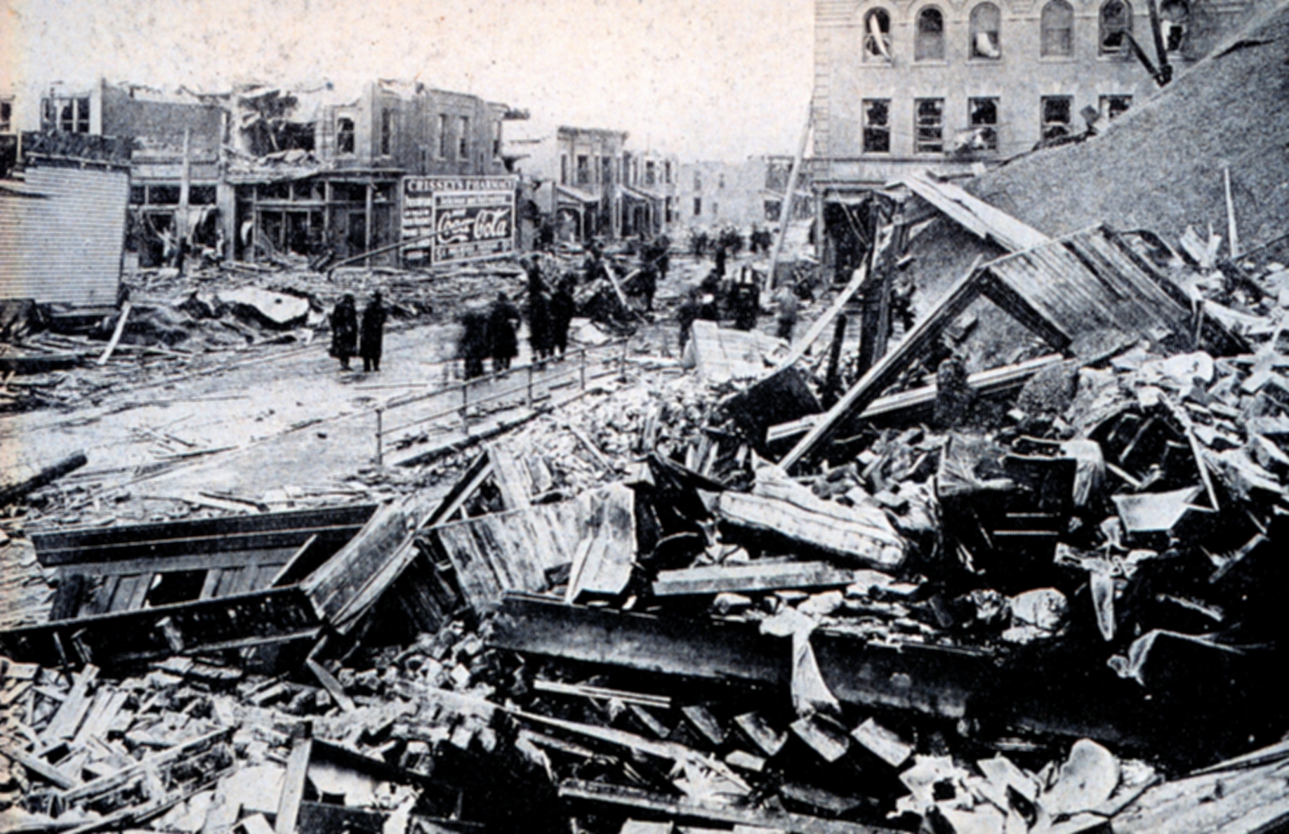
This article is about the 1913 tornado. For the 1975 tornado, see Omaha Tornado of 1975. Photograph of tornado damage in Omaha
The Omaha Easter Sunday Tornado struck Omaha, Nebraska at approximately 6:00 p.m. on 23 March 1913. A massive tornado-producing storm ripped its way through Nebraska, and through the thriving city of Omaha. The storm's path was reported as being 40 miles long and from 1/4- to 1/2-mile wide, and included 8 distinct tornadoes.[1]
Contents
Preceding touchdown in Omaha
Easter Sunday began under cloudy skies in Omaha. Rain threatened but never fell on the city, and by noon the skies had brightened to the point where the sun began to peek through. In the afternoon the skies darkened again as a massive storm system moved into the area from western Nebraska. This storm system brought snow to the Colorado Rockies and high winds to Denver on Sunday morning.
At 5:20 p.m. the first tornado from the storm touched down just outside of Craig, Nebraska. It traveled into Iowa without causing major damage. A second tornado touched down at about 5:30 p.m. near Ithaca, claiming the first casualties of the day as it swept through Yutan. Two other rural tornadoes followed.
At 5:45 p.m. a tornado touched down near Kramer. This tornado raced northeast and reached the outskirts of Omaha around 6:00 p.m.
Tornado enters the city
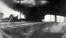 Image of the 1913 Omaha Tornado
The Omaha tornado followed the path of Little Papillion Creek as it entered the city. It moved through the west side of town alongside the Missouri Pacific Railroad, destroying the small workers cottages in the area. The tornado was so strong that steel train cars were later found pierced by pieces of shattered lumber from the demolished homes.
By the time the tornado reached Dewey Avenue it was five blocks wide. When it reached Farnam Hill the twister followed a shallow valley through this upscale neighborhood. The large mansions of Farnam were no match for the winds, and many houses were torn to pieces, along with several in the Gold Coast Historic District including the Joslyn Castle, which sustained considerable damage. Buildings were found chopped in half, pipes and supports dangling into space, such as the Duchesne Academy that was nearly obliterated.
At North 24th and Lake Streets in the Near North Side neighborhood a large African American crowd was enjoying an Easter Sunday performance when the tornado flattened the building and killed more than two dozen people. Other brick structures in this small commercial district took similar hits, and more people died here than in any other part of Omaha.
A streetcar running down North 24th Street in North Omaha encountered the tornado near this area. Thanks to the quick actions of operator Ord Hensley, every passenger on the streetcar survived. Later, photographers would spot the wrecked machine and would call it the "Streetcar of Death," imagining that no one on board could have survived given the immense damage.
The F4 tornado skirted the downtown area and moved over the Missouri River into Council Bluffs. By this time it was losing steam, and although Council Bluffs sustained damage, it escaped the destruction the tornado had brought to Omaha.
The only warning anyone had was a sudden and sharp fall of barometric pressure and temperature. Few had time to seek shelter.
Impact
153 people died, 103 in Omaha, and 400 more were injured. In the aftermath of the tornado, a cold front moved into Omaha and caused further misery, as newly homeless residents struggled to escape the snowy weather.[2]
2,000 homes in Omaha alone were reportedly destroyed, $8 million total damage from the storm, $5.5 million of which was in Omaha (financial damage estimates vary, the NOAA reports more damage than this). The same storm system that struck Nebraska also created a huge dust storm in Topeka, Kansas. On Sunday night, it spawned another deadly tornado in Terre Haute, Indiana, killing 50. On Monday and Tuesday the storm brought heavy rains to the Midwest and upstate New York, causing widespread flooding.
Recovery
Remarkably, operators from the Webster Telephone Exchange Building at 22nd and Lake did not leave their stations either during or after the tornado. The building was used as an infirmary for the wounded and dying, with physicians and nurses coming from area hospitals. US Army troops from Fort Omaha set up headquarters in the building, as soldiers patrolled the area for looters and to offer assistance.
Initially, James Dahlman, the longtime mayor of Omaha, refused assistance from any outside sources, including the federal government. However, he requited after seeing the extent of the damage throughout the city. The federal government poured in assistance soon after. The massive damage caused by the tornado inspired new engineering techniques aimed at creating a tornado-proof edifice. The first such building was the First National Bank of Omaha building, built in 1916 at 1603 Farnam Street. The 14-story building was built in a "U"-shape.
See also
- Disaster Books - Omaha Easter Sunday Tornado
- Great Dayton Flood
- List of North American tornadoes and tornado outbreaks
- List of tornadoes causing 100 or more deaths
- List of tornadoes striking downtown areas
- Timeline of North Omaha, Nebraska history
References
- ^ Condra, G. E.; G. A. Loveland (May 3 1914). "The Iowa-Nebraska Tornadoes Of Easter Sunday, 1913". Bulletin of the American Geographical Society XLVI (2): 100–107. http://books.google.com/?id=-XU9AAAAYAAJ&pg=PA100. Retrieved 2009-08-15.
- ^ Jackman, William James (1911). History Of The American Nation, Vol 6. Chapter CII. "1913, Great Damage By Tornado And Flood". Western Press Association. pp. 1750–1756. http://books.google.com/?id=pOoGAQAAIAAJ&pg=PA1750. Retrieved 2009-08-15.
External links
- National Oceanic and Atmospheric Administration
- (n.d.) Omaha's Terrible Evening. Tragic Story of America's Greatest Disaster.
25 deadliest US tornadoes Rank Name (location) Date Deaths 1 "Tri-State" (Missouri, Illinois and Indiana) March 18, 1925 695 2 Natchez, Mississippi May 6, 1840 317 3 St. Louis, Missouri and East St. Louis, Illinois May 27, 1896 255 4 Tupelo, Mississippi April 5, 1936 216 5 Gainesville, Georgia April 5, 1936 203 6 Woodward, Oklahoma April 9, 1947 181 7 Joplin, Missouri May 22, 2011 159 8 Amite, Louisiana and Purvis, Mississippi April 24, 1908 143 9 New Richmond, Wisconsin June 12, 1899 117 10 Flint, Michigan June 8, 1953 116 11
- - -Waco, Texas
Goliad, TexasMay 11, 1953
May 18, 1902114
11413 Omaha, Nebraska March 23, 1913 103 14 Mattoon, Illinois May 26, 1917 101 15 Shinnston, West Virginia June 23, 1944 100 16 Marshfield, Missouri April 18, 1880 99 17
- - -Gainesville and Holland, Georgia
Poplar Bluff, MissouriJune 1, 1903
May 9, 192798
9819 Snyder, Oklahoma May 10, 1905 97 20 Worcester, Massachusetts June 8, 1953 94 21 Natchez, Mississippi April 24, 1908 91 22 Starkville, Mississippi and Waco, Alabama April 20, 1920 88 23 Lorain and Sandusky, Ohio June 28, 1924 85 24 Udall, Kansas May 25, 1955 80 25 St. Louis, Missouri September 29, 1927 79
Sources: Storm Prediction Center: The 25 Deadliest U.S. Tornadoes, SPC Annual U.S. Killer Tornado StatisticsCategories:- Tornado outbreaks with no Fujita scale ratings given
- Tornadoes of 1913
- Tornadoes in Nebraska
- Natural disasters in Omaha, Nebraska
- North Omaha, Nebraska
- 1913 in Nebraska
- Disasters in Nebraska

Wikimedia Foundation. 2010.