- Drevant
-
Drevant
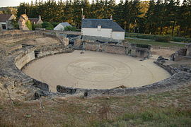
Roman amphitheater 
 Drevant
Administration Country France Region Centre Department Cher Arrondissement Saint-Amand-Montrond Canton Saint-Amand-Montrond Intercommunality Cœur de France Mayor Bernard Jamet
(2008–2014)Statistics Elevation 153–250 m (502–820 ft)
(avg. 168 m/551 ft)Land area1 4.84 km2 (1.87 sq mi) Population2 589 (2008) - Density 122 /km2 (320 /sq mi) INSEE/Postal code 18086/ 18200 1 French Land Register data, which excludes lakes, ponds, glaciers > 1 km² (0.386 sq mi or 247 acres) and river estuaries. 2 Population without double counting: residents of multiple communes (e.g., students and military personnel) only counted once. Coordinates: 46°41′39″N 2°31′33″E / 46.6941666667°N 2.52583333333°E
Drevant is a commune in the Cher department in the Centre region of France.
Contents
Geography
A farming village situated by the banks of the river Cher some 26 miles (42 km) south of Bourges at the junction of the D97 with the D141 and D2144 roads. d
Population
Historical population of Drevant 1962 1968 1975 1982 1990 1999 2008 260 283 355 486 533 610 589 Places of interest
- The church of St.Pierre, dating from the twelfth century.
- The chapel of the eleventh century priory.
- Considerable Gallo-Roman remains, including an amphitheatre, baths, villas and an aqueduct.
See also
References
External links
- Drevant on the Quid website (French)
Categories:- Communes of Cher


Wikimedia Foundation. 2010.