- Milecastle
-
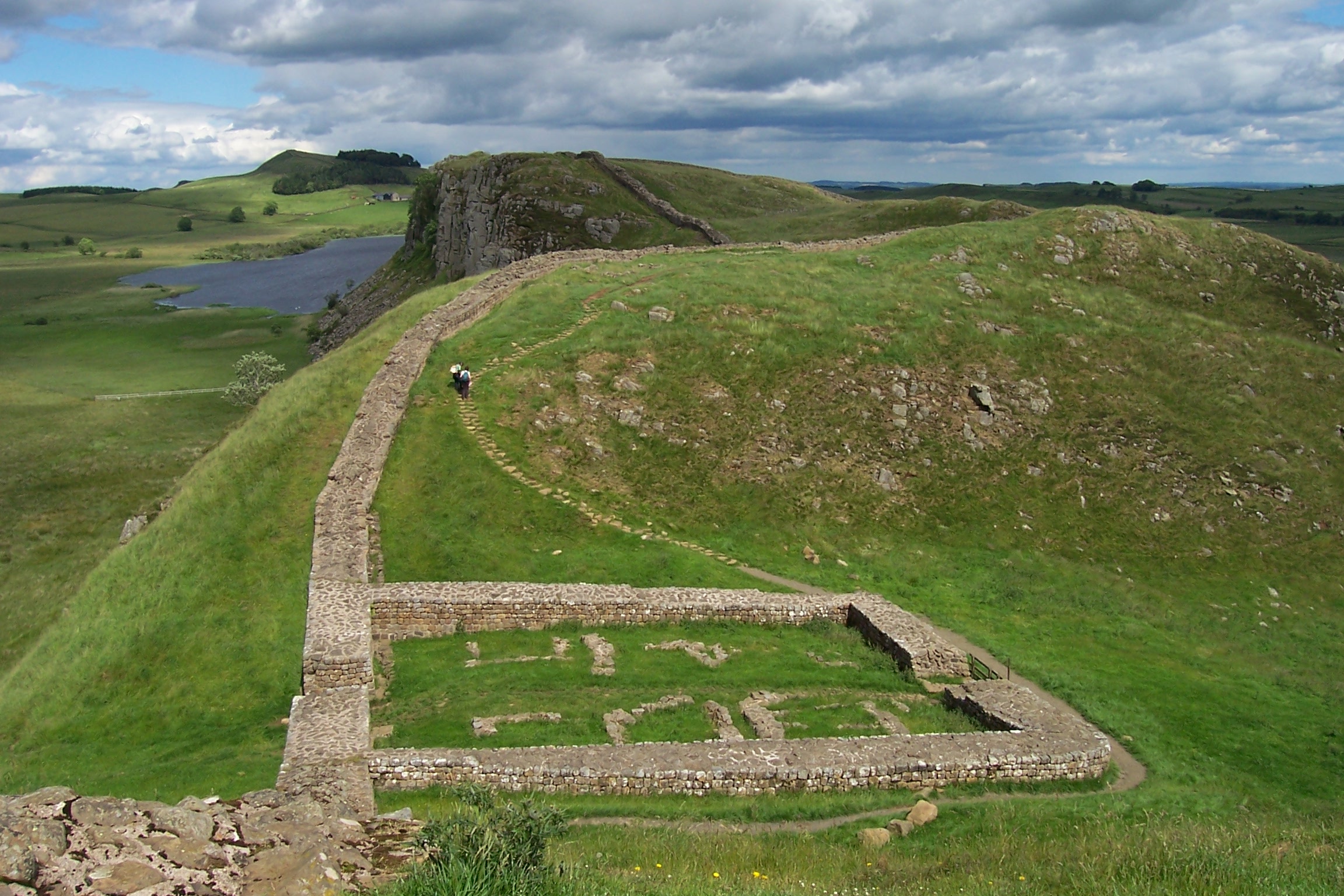
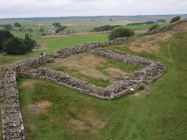
 The remains of Milecastle 39 (Castle Nick), near Steel Rigg.

This article is part of the series on:
Military of ancient Rome (portal)
753 BC – AD 476Structural history Roman army (unit types and ranks, legions, auxiliaries, generals) Roman navy (fleets, admirals) Campaign history Lists of wars and battles Decorations and punishments Technological history Military engineering (castra, siege engines, arches, roads) Political history Strategy and tactics Infantry tactics Frontiers and fortifications (limes, Hadrian's Wall) A milecastle was a small fort (fortlet), a rectangular fortification built during the period of the Roman Empire. They were placed at intervals of approximately one Roman mile along several major frontiers, for example Hadrian's Wall in Great Britain (Britannia in the Roman period), hence the name.
Along Hadrian's Wall, milecastles were initially constructed of stone in the eastern two thirds, and stacked turf with a wooden palisade in the western third, though the turf milecastles were later rebuilt in stone. Size varied, but in general they were about 15m by 18m (16 by 20 yards) internally, with stone walls as much as 3m (10 feet) thick and probably 5m to 6m (17 to 20 feet) high, to match the height of the adjacent wall. There were 80 milecastles and 158 turrets.
On Hadrian's Wall, a milecastle (there are a few exceptions) guarded a gateway through the Wall with a corresponding causeway across the Wall ditch to the north, and had a garrison of perhaps 20–30 auxiliary soldiers housed in two barrack blocks. On either side of the milecastle was a stone tower (turret), located about one-third of a Roman mile (500m or 540 yards) away. It is assumed that the garrison also supplied soldiers to man the turrets. The milecastle's garrison controlled the passage of people, goods and livestock across the frontier, and it is likely that the milecastle acted as a customs post to levy taxation on that traffic.
A system of milecastles and intervening stone watchtowers extended from the western end of Hadrian's Wall, along the Cumbrian coast as far as Ravenglass, but they were linked by a wooden palisade and not a wall fronted by a deep ditch, and they had no gateway through the palisade.[1]
Contents
Terminology and numbering
The term Milecastle was formalised by Robert Smith in 1708, but was in informal use by locals before that date.[2] It generally refers to the installations attached to the curtain wall, with the term 'Milefortlet' being widely used to refer to similar installations that continued along the Cumbrian coast and were contemporary with the Milecastles. Turrets standing between Milefortlets are referred to as 'Towers'.[citation needed]
Milecastles are numbered from 1 (the Easternmost Milecastle) to 80 in the West. This system was introduced by J. Collingwood Bruce in 1930, though Peter Hill has suggested that there may have additionally been a Milecastle 0.[3] Milefortlets are numbered from 1 (West of Bowness on Solway) possibly as far as 26 (at Flimby). The widely used shorthand is, for example, 'MC1', 'MC2', etc. for Milecastles and 'MF1', 'MF2', etc. for Milefortlets. Intervening Turrets and Towers are referred to with an alphabetic suffix, so the turrets to the West of MC20 would be Turrets 20a and 20b, or 'T20a' and 'T20b'.[citation needed] Despite evidence of the curtain wall continuing for around a quarter of a mile west of Bowness-on-Solway, the Turrets between MC80 and MF1 are known as Towers 0a and 0b.[citation needed]
Where the Turf Wall and Stone Walls diverge from one another (just to the west of Birdoswald), Milecastles and Turrets unique to the Turf Wall are given a 'TW' suffix, for example 'MC50 TW'.[citation needed]
Milecastle plans
Gateways
The milecastles of Hadrian's Wall are recognised as having three principal types of gateway.[4]
Type I have piers protruding symmetrically on the inside and outside of the gateway, with responds on both the inside and outside. The piers and passage-walls tend to be in large masonry, and the structure is broader (E to W) than it is deep (N to S, i.e. between the gateways). Examples are MC 38 (Hotbank) and MC 42 (Cawfields). Generally thought to have been built by legio II Augusta.[5]
Type II have piers protruding on the inside of the gateway, with responds on outside. The piers and passage-walls tend to be in smaller masonry than Type I. Only found on Narrow Wall milecastles; when similar gateways are found on Broad Wall milecastles, it is sometimes referred to as Type IV. An example is MC 9 (Chapel House). Generally thought to have been built by legio XX Valeria Victrix.[5]
Type III have piers protruding on the inside of the gateway, with responds on both the inside and outside. The piers tend to be in large masonry and the passage-walls in smaller material. Examples are MC 47 (Chapel House, E of Gilsland) and MC 48 (Poltross Burn). Generally thought to have been built by legio VI Victrix.[5]
Axes
Two types of milecastle are discernable in plan. These are known as 'Long Axis' and 'Short Axis', with the referred axis being that between the northern and southern gateways. The only (known) exception is the Milecastle 79. This was a Turf Wall milecastle, which was subsequently rebuilt with stone.
- Gateway Type I – Short-axis milecastles built by legio II Augusta[5]
- Gateway Types II and IV – long-axis milecastles built by legio XX Valeria Victrix[5]
- Gateway Type III – Long-axis milecastles built by legio VI Victrix[5]
References
- ^ Stephen Johnson (2004) Hadrian's Wall, Sterling Publishing Company, Inc, 128 pages, ISBN 0-7134-8840-9
- ^ Birley, E. (1961) Research on Hadrian’s Wall, Titus Wilson & Son (Kendal)
- ^ Hill, Peter (2001) ‘Hadrian’s Wall from MC0 to MC9, Archaeologia Aeliana series 5, Volume 29, The Society of Antiquaries of Newcastle-upon-Tyne
- ^ Stephen Johnson (2004) Hadrian's Wall, Sterling Publishing Company, Inc, 128 pages, ISBN 0-7134-8840-9 pp 31–32
- ^ a b c d e f Wilmot, Tony (1 Oct 2009), Hadrian's Wall: Archaeological Research by English Heritage 1976-2000, Frank Graham, pp. 137–138, ISBN 9781905624713
External links
 Media related to Milecastles of Hadrian's Wall at Wikimedia Commons
Milecastles of Hadrian's Wall Milecastles 0 • 1 • 2 • 3 • 4 • 5 • 6 • 7 • 8 • 9 • 10 • 11 • 12 • 13 • 14 • 15 • 16 • 17 • 18 • 19 • 20 • 21 • 22 • 23 • 24 • 25 • 26 • 27 • 28 • 29 • 30 • 31 • 32 • 33 • 34 • 35 • 36 • 37 • 38 • 39 • 40 • 41 • 42 • 43 • 44 • 45 • 46 • 47 • 48 • 49 • 50 • 50TW • 51 • 52 • 53 • 54 • 55 • 56 • 57 • 58 • 59 • 60 • 61 • 62 • 63 • 64 • 65 • 66 • 67 • 68 • 69 • 70 • 71 • 72 • 73 • 74 • 75 • 76 • 77 • 78 • 79 • 80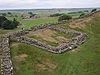
Milefortlets MF 1 • MF 2 • MF 3 • MF 4 • MF 5 • MF 6 • MF 7 • MF 8 • MF 9 • MF 10 • MF 11 • MF 12 • MF 13 • MF 14 • MF 15 • MF 16 • MF 17 • MF 18 • MF 19 • MF 20 • MF 21 • MF 22 • MF 23 • MF 24 • MF 25 • MF 26Other structures on Hadrian's Wall Portgate • Chesters Bridge • Knag Burn Gateway • Peel Gap Tower • Willowford Bridge • Pike Hill Signal TowerCategories:- Roman sites in Northumberland
- Milecastles of Hadrian's Wall
- Forts of Hadrian's Wall

Wikimedia Foundation. 2010.