Montfuron

Montfuron

Montfuron

Village-montfuron-1.JPG
Coat of arms of Montfuron
Montfuron is located in France
{{{alt}}}
Montfuron
Administration
Country France
Region Provence-Alpes-Côte d'Azur
Department Alpes-de-Haute-Provence
Arrondissement Forcalquier
Canton Manosque-Sud-Ouest
Intercommunality Luberon Durance Verdon
Mayor Pierre Fischer
(2008–2014)
Statistics
Elevation 373–706 m (1,224–2,316 ft)
(avg. 650 m/2,130 ft)
Land area1 18.88 km2 (7.29 sq mi)
Population2 198  (2008)
 - Density 10 /km2 (26 /sq mi)
INSEE/Postal code 04128/ 04110
1 French Land Register data, which excludes lakes, ponds, glaciers > 1 km² (0.386 sq mi or 247 acres) and river estuaries.
2 Population without double counting: residents of multiple communes (e.g., students and military personnel) only counted once.

Coordinates: 43°50′12″N 5°41′41″E / 43.8366666667°N 5.69472222222°E / 43.8366666667; 5.69472222222

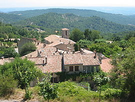
Montfuron is a commune in the Alpes-de-Haute-Provence department in southeastern France.

Population

Historical population of Montfuron
1765 1793 1800 1806 1821 1831 1836 1841 1846 1851
310 368 406 368 359 414 405 409 391 390
1856 1861 1866 1872 1876 1881 1886 1891 1896 1901
354 360 353 357 306 310 272 246 228 201
1906 1911 1921 1926 1931 1936 1946 1954 1962 1968
197 155 125 129 97 76 86 81 48 86
1975 1982 1990 1999 2008
79 156 149 166 198

See also

References


Wikimedia Foundation. 2010.

Игры ⚽ Поможем написать курсовую

Look at other dictionaries:

  • Montfuron — Escudo …   Wikipedia Español

  • Montfuron — 43° 50′ 12″ N 5° 41′ 41″ E / 43.8366666667, 5.69472222222 …   Wikipédia en Français

  • Moulin Saint-Elzéar de Montfuron — Présentation Type Moulin à vent Date de construction 1640 Gé …   Wikipédia en Français

  • Chapelle Saint-Elzéar de Montfuron — Présentation Nom local Chapelle Saint Elzéar Culte Catholique romain Type Chapelle Rattaché à Diocèse de Digne Début de la construction XIIIe …   Wikipédia en Français

  • Col de Montfuron — Altitude 649 m Massif Massif du Luberon Latitude Long …   Wikipédia en Français

  • Moulin des Arnoux de Montfuron — Présentation Type Moulin à vent Géographie Pays  France …   Wikipédia en Français

  • Église Notre-Dame-et-Saint-Elzéar de Montfuron — Pour les articles homonymes, voir Église Notre Dame. Église Notre Dame et Saint Elzéar de Montfuron …   Wikipédia en Français

  • Route départementale 455 (Alpes-de-Haute-Provence) — Route départementale 455  D 455  Caractéristiques Longueur 1 km Direction Nord/Sud Extrémité Nord Col de Montfuron Intersectio …   Wikipédia en Français

  • Villemus — 43° 51′ 35″ N 5° 42′ 06″ E / 43.8597222222, 5.70166666667 …   Wikipédia en Français

  • Manosque — 43° 50′ 03″ N 5° 47′ 02″ E / 43.8341666667, 5.78388888889 …   Wikipédia en Français

Share the article and excerpts

Direct link
Do a right-click on the link above
and select “Copy Link”