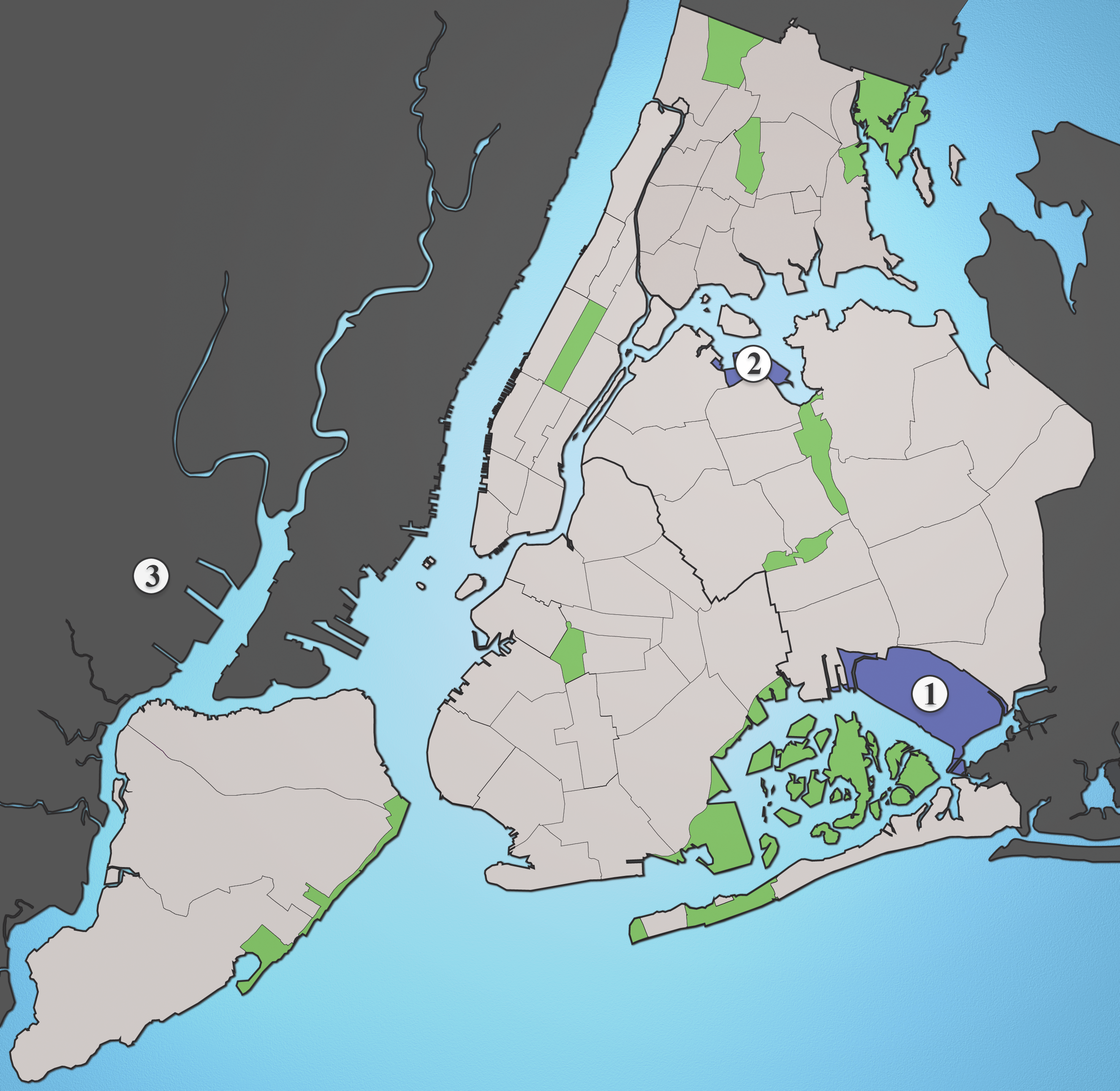
- Transportation to New York City area airports
-
Transportation to New York City area airports is provided by trains (AirTrain JFK and AirTrain Newark), buses, taxi cabs, private shuttle services, helicopters and other means. The three major airports are:
- John F. Kennedy International Airport (JFK)
- LaGuardia Airport (LGA)
- Newark Liberty International Airport (EWR)
None of these airports are directly served by the area's commuter rail and subway systems and LaGuardia has no rail service at all.
Both JFK and LaGuardia are located in the New York City borough of Queens while Newark Liberty is located in Newark, New Jersey. Smaller airports around New York City include Long Island MacArthur Airport in Islip, Westchester County Airport in White Plains and Stewart International Airport in Newburgh.
Private bus services, most notably the New York Airport Service (from JFK and La Guardia) and Newark Liberty Airport Express, transport passengers outside major transit hubs (including New York Penn Station, Grand Central Terminal and the Port Authority Bus Terminal) and hotels to the airports.
JFK and Newark Liberty Airports are served, respectively, by two short rail lines both known as AirTrain that connect to other nearby transportation systems. AirTrain Newark is a light monorail whose railcars can never travel on the existing infrastructure of commuter or rapid transit lines, while AirTrain JFK is capable of handling heavy rail subway trains and could, in theory, send railcars onto rapid transit or commuter rail tracks. All three airports have connecting bus service to other transit.
See also: Transportation in New York CityContents
John F. Kennedy International Airport
 The A train serves JFK Airport via the Howard Beach – JFK Airport station.
AirTrain JFK
AirTrain JFK provides rail service to JFK via two transfer stations. One branch runs to Jamaica and the other to Howard Beach, which is served at all times by the A train.
Jamaica
The Jamaica AirTrain terminus is part of a large transportation complex that includes many connections:
- Sutphin Boulevard – Archer Avenue – JFK Airport on the New York City Subway's Archer Avenue Line – served by the E J Z trains.
- Jamaica station, which is a major transfer hub on the Long Island Rail Road (LIRR)
- numerous local buses, including the Q6, Q8, Q9, Q20A, Q20B, Q24, Q30, Q31, Q41, Q43, Q44, along with the Q60 bus running into Manhattan. In addition, many more bus routes are within walking distance of Jamaica Station.[1]
Howard Beach
The Howard Beach AirTrain terminus is right above Howard Beach – JFK Airport on the IND Rockaway Line of the New York City Subway.
Accessibility, costs and typical travel times
All of these AirTrain connections and Penn Station are handicapped accessible; however many other area stations are not. For more information, see New York City Subway accessibility and Long Island Rail Road accessibility.
AirTrain costs $5 per ride, the subway costs $2.25, and the LIRR to anywhere with New York City except Far Rockaway costs $8 during peak hours, $5.75 at other weekday times, and $3.50 on weekends (with the CityTicket pilot program). Fares can be paid with MetroCards, available from vending machines at the AirTrain termini. Costs and typical travel times are as follows:[2][3]
Mode Cost Optimal Time to Manhattan AirTrain and LIRR $13 peak, $10.75 nonpeak, $8.50 weekends 35 minutes (Midtown, west side) AirTrain and E Subway $7.25 45 minutes (Midtown, east side) AirTrain and A Subway $7.25 1 hour (lower Manhattan) MTA Regional Bus routes
Various MTA Regional Bus (New York City Bus and MTA Bus) connect to the Subway and Long Island Rail Road with free transfers provided for Subway connections. The buses are handicapped accessible, but connections may not be. All three bus routes provide 24 hour service to and from their respective areas. Most enter the airport on Van Wyck Expressway, with the only passenger terminal stop at the International Arrivals building (Terminal 4).
- B15 Marcus Garvey Boulevard/New Lots Avenue
Main article: Sumner Avenue Line and New Lots Avenue LineThe B15, operated by MTA New York City Transit, takes a long route through sections of Conduit Avenue and New Lots Avenue, ending at Woodhull Hospital in Brooklyn. It passes the following rail stations (in order from JFK):
- Terminal 4 - end of the route

- Federal Circle on the AirTrain JFK
- Lefferts Boulevard on the AirTrain JFK
- New Lots Avenue (2 3 4 5 trains) on the IRT New Lots Line
- New Lots Avenue (L train) on the BMT Canarsie Line
- Sutter Avenue – Rutland Road (2 3 4 5 trains) on the IRT New Lots Line
- Kingston–Throop Avenues (A C trains) on the IND Fulton Street Line
- Myrtle Avenue (J M Z trains) on the BMT Jamaica Line
- Flushing Avenue (J trains ) on the BMT Jamaica Line – end of the route
- Q3 Farmers Boulevard
The Q3, operated by MTA New York City Transit, runs mainly along Farmers Boulevard and Hillside Avenue to Jamaica, accessing the following rail stations (in order from JFK):
- Terminal 4 - end of the route
- Locust Manor on the LIRR
- Hollis on the LIRR
- Jamaica – 179th Street (E F trains) on the IND Queens Boulevard Line
- 169th Street (F train) on the IND Queens Boulevard Line
- 165th Street Bus Terminal – end of the route
- Q10 Lefferts Boulevard
The Q10, operated by MTA Bus Company, runs mainly via Lefferts Boulevard to Kew Gardens, with the following transfers along the way (in order from JFK):
- JFK terminal 4 – end of the route; stop is on the east side of the terminal only (not with the other MTA busses)
- Ozone Park – Lefferts Boulevard (A train) on the IND Fulton Street Line
- 121st Street (J Z trains) on the elevated BMT Jamaica Line
- Kew Gardens on the LIRR
- Kew Gardens – Union Turnpike (E F trains) on the IND Queens Boulevard Line – end of the route
Limited stop service also runs weekdays, Saturdays and Sundays from 7am to 8pm.
- Q6 Sutphin Boulevard
The Q6, operated by MTA Bus Company runs to Jamaica from the post office via Rockaway and Sutphin Bouelvards, with the following transfers along the way (in order from JFK):
- JFK Cargo Area – end of the route
- Sutphin Boulevard – Archer Avenue – JFK Airport (E J Z trains) on the Archer Avenue Line, as well as Jamaica station on the Long Island Rail Road.
- 165th Street Bus Terminal – end of the route
Limited stop service also runs weekday rush hours in the peak direction.
- Q7 Rockaway Boulevard
The Q7, operated by MTA Bus Company runs to East New York from the cargo area via Rockaway Boulevard and Pitkin Avenue, with the following transfers along the way (in order from JFK):
- JFK Cargo Area – end of the route
- Rockaway Boulevard (A train) on the IND Fulton Street Line
- Grant Avenue (A train) on the IND Fulton Street Line
- Euclid Avenue (A C trains) on the IND Fulton Street Line – end of the route
Taxicabs
New York City's yellow cabs, regulated by the New York City Taxi and Limousine Commission, offer a flat rate service of $45 (as of 2006) from JFK airport to Manhattan, excluding tips and tolls. This flat rate is in effect either way between Manhattan and JFK.[4]
Defunct transportation
New York Airways provided helicopter service from the Pan Am Building through the 1970s. With the cessation of services by US Helicopter in September 2009, there have been no scheduled links from the Downtown Manhattan Heliport and East 34th Street Heliport to any New York City airports.
JFK Express, advertised as The Train to The Plane, was a service of the New York City Subway from 1978 to 1990. It ran from midtown Manhattan (later Long Island City, Queens) to downtown Brooklyn, making stops along the way, and then made no stops between Downtown Brooklyn and Howard Beach – JFK Airport, where a bus connected to the airport.
LaGuardia Airport
LaGuardia (LGA) is the only one of the three main airports with no rail service, though early plans for AirTrain JFK would have taken it north past Jamaica to LaGuardia. Thus the only public transportation is provided by buses. There were plans to extend to BMT Astoria Line to the airport, but this was scrapped in 2003 due to opposition from residents of Astoria, New York [5].
MTA Regional Bus routes
The following city buses connect to the New York City Subway and Long Island Rail Road, with free transfers provided for subway connections. The buses are handicapped accessible, but connections may not be.
M60 LaGuardia Airport via 125th Street
Main article: M60 (New York City bus)The M60, operated by MTA New York City Transit, runs from LGA to the Upper West Side, Manhattan via Astoria Boulevard, the Robert F. Kennedy Bridge and 125th Street, with the following transfers along the way (in order from LGA):
- All LGA terminals - end of the route
- Astoria Boulevard (N Q trains) on the BMT Astoria Line
- 125th Street (4 5 6 <6> trains) on the IRT Lexington Avenue Line
- Harlem – 125th Street on Metro-North Railroad
- 125th Street (2 3 trains) on the IRT Lenox Avenue Line
- 125th Street (A B C D trains) on the IND Eighth Avenue Line
- 116th Street – Columbia University (1 train) on the IRT Broadway – Seventh Avenue Line
- Cathedral Parkway – 110th Street (1 train) on the IRT Broadway – Seventh Avenue Line
Q33 82nd Street
Main article: Q33 (New York City bus)The Q33, operated by MTA Bus Company, uses mainly 82nd Street and 83rd Street between LGA and Jackson Heights. The following transfers are available (in order from LGA):
- All LGA terminals but the Marine Air Terminal - end of the route
- 82nd Street – Jackson Heights (7 train) on the IRT Flushing Line
- Roosevelt Avenue / 74th Street (7 E F M R trains) on the IRT Flushing and IND Queens Blvd. lines – end of the route
Q47 74th Street
Main article: Q47 (New York City bus)The Q47, operated by MTA Bus Company, uses mainly 73rd Street and 74th Street between LGA and The Shops at Atlas Park. The following transfers are available (in order from LGA):
- LGA Marine Air Terminal only - end of the route
- Roosevelt Avenue / 74th Street (7 E F M R trains) on the IRT Flushing and IND Queens Blvd. lines –
- 69th Street (7 train)
Q48 Roosevelt Avenue/Ditmars Boulevard/LaGuardia Airport
Main article: Q48 (New York City bus)The Q48, operated by MTA New York City Transit, runs via Ditmars Boulevard and Roosevelt Avenue to Flushing. The following transfers are available (in order from LGA):
- All LGA terminals - end of the route
- 111th Street (7 train) on the IRT Flushing Line
- Mets – Willets Point (7 <7> trains) on the IRT Flushing Line
- Mets – Willets Point on the LIRR
- Flushing – Main Street (7 <7> trains) on the IRT Flushing Line
- Flushing Main Street on the LIRR – end of the route
Q72 Junction Boulevard
Main article: Q72 (New York City bus)The Q72 operated by the MTA Bus Company runs via 94th Street and Junction Boulevard through East Elmhurst to Rego Park. The following transfers are available (in order from LGA):
- All LGA terminals except the Marine Air Terminal - end of the route
- Junction Boulevard (7 <7> trains) on the IRT Flushing Line
- 63rd Drive – Rego Park (E M R trains) on the Queens Boulevard Line - end of the route
Newark Liberty International Airport
Newark Airport (EWR) has rail and bus service.
AirTrain
AirTrain Newark originally served as a circulator between terminals, but on October 21, 2001, the extension to the new Newark Liberty International Airport station on the Northeast Corridor opened. As the station serves only airport traffic, AirTrain fare is included in rail fare, except for monthly pass holders, who pay $5.50 to ride AirTrain. New Jersey Transit and Amtrak serve the station, both going to various New Jersey points as well as New York Penn Station.
On December 8, 2005, the Port Authority announced that an extension of the PATH system to Newark Airport was included in its 2006–2015 Strategic Plan.[6] The estimated cost of $550 million is not yet budgeted.
New Jersey Transit buses
New Jersey Transit operates several bus routes via EWR. The most useful are route 62 from Newark Penn Station, via EWR, to Woodbridge Center or Perth Amboy, and Go28 from Bloomfield train station, via University Heights or Broad St. station, and Market Street south to EWR. Route 62 provides a lower-cost alternative to Manhattan: $1.50 bus fare and $5.00 NJ Transit train fare from Newark Penn Station to New York Penn Station, or $1.75 on PATH to World Trade Center or 33rd St/6th Avenue, compared with $12.50 from EWR NJ Transit station.
37 Newark–Maplewood
The 37 runs between EWR and Ivy Hill in southwestern Newark via Lyons Avenue, passing the following rail stations and other major points (in order from EWR):
- EWR main terminals and North Area - end of the route
- Ivy Hill - end of the route
40 Jersey Gardens–Kearny
The 40 runs between North Arlington and Jersey Gardens in eastern Elizabeth, passing the following rail stations and other major points (from north to south):
- North Arlington - end of the route
- Harrison on Port Authority Trans-Hudson
- Newark Penn Station on Amtrak, New Jersey Transit, Port Authority Trans-Hudson (PATH) and Newark City Subway.
- EWR North Area only
- Jersey Gardens - end of the route
While the #40 bus does not directly serve the main terminals, it stops at the 'North Area' bus stop (on U.S. Route 1/9) which adjoins long-term parking lot P6. The free P6 shuttle bus connects from this parking lot to the terminals.
62 Newark–Perth Amboy
The 62 runs between downtown Newark and downtown Perth Amboy, passing the following rail stations and other major points (from north to south):[7]
- Newark Penn Station on Amtrak, New Jersey Transit, PATH and Newark City Subway - end of the route
- EWR - main terminals and South Area
- Elizabeth on New Jersey Transit
- Rahway on New Jersey Transit
- Metro Park on Amtrak and New Jersey Transit - only some buses
- Perth Amboy on New Jersey Transit - only some buses - end of the route
67 Toms River–Lakewood–Newark
The 67 runs between downtown Newark (some trips extend to Journal Square, Jersey City and a few to Lincoln Harbor, Weehawken) and Toms River. Only some trips stop at EWR, passing the following rail stations and other major points (from north to south):
- Toms River - end of the route
- EWR - main terminals
- Newark Penn Station on Amtrak, New Jersey Transit, Port Authority Trans-Hudson and Newark City Subway - end of the route
- Journal Square on Port Authority Trans-Hudson
- Lincoln Harbor on Hudson–Bergen Light Rail
107 South Orange–New York
The 107 runs between South Orange and the Port Authority Bus Terminal in Midtown Manhattan. Only some trips stop at EWR, passing the following rail stations and other major points (from west to east):
- South Orange on New Jersey Transit - end of the line
- EWR - main terminals and North Area
- Port Authority Bus Terminal
- 42nd Street – Port Authority Bus Terminal (A C E trains) on the IND Eighth Avenue Line
NJ Transit does not allow travel from Airport Terminals to New York on this route. Passengers must use Olympia Bus Lines or take ground transportation to the North Area bus stop.
Other Area Airports
Long Island MacArthur Airport
Long Island MacArthur Airport in Ronkonkoma, New York, serves residents of Suffolk County in Long Island.
Ronkonkoma on the Long Island Rail Road's Ronkonkoma Branch is 1.5 miles away from this airport and numerous Taxicab services connect the airport with this station in addition to the shuttle bus operated by the Colonial Transportation company and Suffolk Transit's S57 route. The S57 route also connects the airport with Sayville, New York and the Smith Haven Mall in Lake Grove, New York.[8]
Westchester County Airport
Westchester County Airport, often called White Plains Airport for the city near the airport, is located in Harrison, New York, and serves residents of Westchester County and Fairfield County, Connecticut.
The Bee-Line Bus System serves the airport through its 12 route, connecting it with Armonk and White Plains.[9]
Stewart International Airport
Stewart International Airport is located in New Windsor, Orange County, New York, adjacent to Newburgh, New York. The airport was recently purchased by the Port Authority of New York and New Jersey.
Currently, the airport is only served by bus and taxi service. The only regularly scheduled service to the airport is provided by Leprechaun Lines' The Link, which links the Metro-North station in Beacon, New York to Downtown Newburgh, terminating at the airport.[10]
Since the Port Authority's purchase of the airport, studies of future transportation from New York City to the airport are being conducted. One feasible option is a spur from the Port Jervis Line of Metro-North, as its Salisbury Mills-Cornwall station is 4.5 miles from the terminal,[11] and the closest point on the Port Jervis Line is only 3.5 miles away.
References
- ^ Queens bus routes, accessed July 25, 2006 - see Jamaica inset on bottom right of map
- ^ AirTrain JFK Brochure, accessed January 18, 2010
- ^ MTA System Schedules, accessed July 25, 2006
- ^ Taxi & Limousine Commission: Passenger Information - Rate of Fare, accessed December 27, 2006
- ^ Toscano, John (July 16, 2003). "N Train Extension To LaG Scrapped". Queens Gazette. http://www.qgazette.com/news/2003/0716/Front_Page/002.html. Retrieved September 15, 2009.
- ^ 2006–2015 Strategic Plan, accessed December 27, 2006[dead link]
- ^ http://www.njtransit.com/pdf/bus/T0062.pdf
- ^ MacArthur Airport Unofficial Website
- ^ Westchester County Airport Official Website - Public Transit
- ^ The Link
- ^ Logan, Tim (March 24, 2005). "Kelly Hopes Senate on Board for Train to Stewart". Times Herald-Record. http://archive.recordonline.com/archive/2005/03/24/bizb24.htm. Retrieved September 15, 2009.
External links
- MTA Website
- Port Authority of New York and New Jersey (which runs Airtrain)
- New York Airport Service (private bus company)
- Subway/bus directions site
Airports in the New York City area Major commercial airports 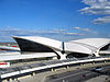
Secondary commercial airports General aviation airports Brookhaven • Danbury • Essex County • Linden • Morristown • Republic • Teterboro • Trenton-Mercer • SikorskyHeliports Transportation AirTrain JFK • AirTrain Newark • Transportation to New York City area airports


Wikimedia Foundation. 2010.