- Dixons Mills, Alabama
-
Dixons Mills, Alabama Location within the state of Alabama
 Dixons Mills, Alabama
Coordinates: 32°3′29.02″N 87°47′15″W / 32.0580611°N 87.7875°WCoordinates: 32°3′29.02″N 87°47′15″W / 32.0580611°N 87.7875°W Country United States State Alabama County Marengo Elevation 207 ft (63 m) Time zone Central (CST) (UTC-6) – Summer (DST) CDT (UTC-5) ZIP code 36736 Area code(s) 334 Dixons Mills is an unincorporated community in Marengo County, Alabama, United States.[1] The community was named for a group of mills operated by Joel B. Dixon in the 19th century.[2] Dixons Mills has a post office utilizing the 36736 ZIP code.[3]
Contents
History
Beginning in the late 1820s, Joel B. Dixon, Sr. operated a water-powered gristmill at a dam that he and his sons built on Mill Creek along the old Linden-to-Choctaw Corner Road. The modern U.S. Route 43 bridge over Mill Creek now stands at the location. Dixon (January 11, 1777–December 23, 1861), a native of Edgecombe County, North Carolina, was one of the early settlers of Marengo County. His business grew and eventually included a steam engine-driven sawmill and two steam-powered cotton gins. The mills remained in use into the first years of the 20th century. They were still standing in 1923, when they were demolished during the construction of Route 43.[2]
Geography
Dixons Mills is located at 32°03′29″N 87°47′15″W / 32.05806°N 87.78750°W and has an elevation of 207 feet (63 m).[1]
School
Dixons Mills only remaining school is Marengo High School. It is part of the Alabama Public School System.
References
- ^ a b U.S. Geological Survey Geographic Names Information System: Dixons Mills
- ^ a b Marengo County Heritage Book Committee: The Heritage of Marengo County, Alabama, pages 177-178. Clanton, Alabama: Heritage Publishing Consultants, 2000. ISBN 189164758X
- ^ U.S. Geological Survey Geographic Names Information System: Dixons Mills Post Office
Municipalities and communities of Marengo County, Alabama Cities 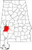
Towns Dayton | Faunsdale | Myrtlewood | Providence | Sweet Water | Thomaston
Unincorporated
communitiesAimwell | Alfalfa | Beaver Creek | Clay Hill | Consul | Coxheath | Dixons Mills | Exmoor | Half Acre | Half Chance | Hampden | Hoboken | Hugo | Jefferson | Lasca | McKinley | Magnolia | Marengo | Moores Valley | Moscow | Nanafalia | Nicholsville | Octagon | Old Spring Hill | Pin Hook | Putnam | Rembert | Salt Well | Shiloh | Siddonsville | Surginer | Vangale | Vineland | Wayne
Ghost town Aigleville
Categories:- Unincorporated communities in Alabama
- Populated places in Marengo County, Alabama
- Alabama geography stubs


Wikimedia Foundation. 2010.