- Chester Township, Clinton County, Ohio
-
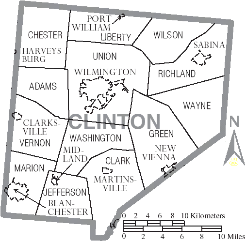
Chester Township, Ohio — Township — Municipalities and townships of Clinton County.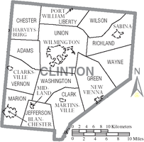
Coordinates: 39°31′12″N 83°56′26″W / 39.52°N 83.94056°WCoordinates: 39°31′12″N 83°56′26″W / 39.52°N 83.94056°W Country United States State Ohio County Clinton Area – Total 31.9 sq mi (82.7 km2) – Land 31.8 sq mi (82.4 km2) – Water 0.1 sq mi (0.4 km2) Elevation[1] 1,001 ft (305 m) Population (2000) – Total 1,771 – Density 55.7/sq mi (21.5/km2) Time zone Eastern (EST) (UTC-5) – Summer (DST) EDT (UTC-4) FIPS code 39-13974[2] GNIS feature ID 1085877[1] Chester Township is one of the thirteen townships of Clinton County, Ohio, United States. The 2000 census found 1,771 people in the township,[3] up from 1,200 in 1990.
Contents
Geography
Located in the northwest corner of the county, it borders the following townships:
- Caesarscreek Township, Greene County - northeast
- Liberty Township - east
- Union Township - southeast
- Adams Township - south
- Massie Township, Warren County - southwest
- Wayne Township, Warren County - west
- Spring Valley Township, Greene County - northwest
Caesar Creek State Park is partially located in Chester Township.
No municipalities are located in Chester Township.
Transportation
Major roads are Interstate 71 and State Routes 73 and 380.
Name and history
It is one of five Chester Townships statewide.[4]
Government
The township is governed by a three-member board of trustees, who are elected in November of odd-numbered years to a four-year term beginning on the following January 1. Two are elected in the year after the presidential election and one is elected in the year before it. There is also an elected township fiscal officer,[5] who serves a four-year term beginning on April 1 of the year after the election, which is held in November of the year before the presidential election. Vacancies in the fiscal officership or on the board of trustees are filled by the remaining trustees.
References
- Clinton County Historical Society. Clinton County, Ohio, 1982. Wilmington, Ohio: The Society, 1982.
- Ohio Atlas & Gazetteer. 6th ed. Yarmouth, Maine: DeLorme, 2001. ISBN 0-89933-281-1
- Ohio. Secretary of State. The Ohio municipal and township roster, 2002-2003. Columbus, Ohio: The Secretary, 2003.
- ^ a b "US Board on Geographic Names". United States Geological Survey. 2007-10-25. http://geonames.usgs.gov. Retrieved 2008-01-31.
- ^ "American FactFinder". United States Census Bureau. http://factfinder.census.gov. Retrieved 2008-01-31.
- ^ Clinton County, Ohio — Population by Places Estimates Ohio State University, 2007. Accessed 15 May 2007.
- ^ "Detailed map of Ohio" (PDF). United States Census Bureau. 2000. http://www2.census.gov/geo/maps/general_ref/cousub_outline/cen2k_pgsz/oh_cosub.pdf. Retrieved 2007-02-16.
- ^ §503.24, §505.01, and §507.01 of the Ohio Revised Code. Accessed 4/30/2009.
External links
Municipalities and communities of Clinton County, Ohio City 
Villages Blanchester‡ | Clarksville | Lynchburg‡ | Martinsville | Midland | New Vienna | Port William | Sabina
Townships Unincorporated
communitiesCuba | Lees Creek | Reesville
Footnotes ‡This populated place also has portions in an adjacent county or counties
Categories:- Townships in Clinton County, Ohio

Wikimedia Foundation. 2010.