- Clymer, New York
-
Clymer — Town — Little Red Schoolhouse in 1997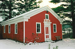 Location within the state of New York
 Clymer
Coordinates: 42°2′7″N 79°35′17″W / 42.03528°N 79.58806°W Country United States State New York County Chautauqua Government - Type Town Council - Town Supervisor Ralph J. Holthouse (R) - Town Council Members' ListArea - Total 36.1 sq mi (93.5 km2) - Land 36.1 sq mi (93.4 km2) - Water 0.1 sq mi (0.1 km2) Elevation 1,480 ft (451 m) Population (2000) - Total 1,501 - Density 41.6/sq mi (16.1/km2) Time zone Eastern (EST) (UTC-5) - Summer (DST) EDT (UTC-4) ZIP code 14724 Area code(s) 716 FIPS code 36-16595 GNIS feature ID 0978842 Clymer is a town in Chautauqua County, New York, United States. The population was 1,501 at the 2000 census. The town is named for George Clymer, a signer of the Declaration of Independence.
The Town of Clymer is located in the southwest part of the county.
Contents
History
Settlement began around 1820. The Town of Clymer was established in 1829 from a division of the Town of Chautauqua. In 1821, a division of Clymer was made to form the new Town of Mina and again in 1829 to form the Town of French Creek.
In 1915, the population of Clymer was 1,341.
Neckers Co., a general store, has occupied the northwest corner of the main intersection in town since 1910, passing through four generations of the Neckers family.
The Clymer District School No. 5 was listed on the National Register of Historic Places in 1994.[1]
Geography
According to the United States Census Bureau, the town has a total area of 36.1 square miles (93 km2), of which, 36.1 square miles (93 km2) of it is land and 0.1 square miles (0.26 km2) of it (0.14%) is water.
New York State Route 474 passes through the town and intersects New York State Route 76 in North Clymer.
Adjacent towns and regions
Clymer borders Wayne Township, Erie County, Pennsylvania and Columbus Township, Warren County, Pennsylvania to the south. The Town of French Creek is to the west and the Town of Harmony is to the east. The Town of Sherman is north of Clymer.
Demographics
As of the census[2] of 2000, there were 1,501 people, 502 households, and 400 families residing in the town. The population density was 41.6 people per square mile (16.1/km²). There were 550 housing units at an average density of 15.3 per square mile (5.9/km²). The racial makeup of the town was 99.13% White, 0.07% African American, 0.13% Native American, 0.27% Asian, 0.20% from other races, and 0.20% from two or more races. Hispanic or Latino of any race were 0.47% of the population.
There are 502 households out of which 39.6% have children under the age of 18 living with them, 72.3% were married couples living together, 4.4% had a female householder with no husband present, and 20.3% were non-families. 17.5% of all households were made up of individuals and 9.2% had someone living alone who was 65 years of age or older. The average household size was 2.99 and the average family size was 3.40.
In the town the population was spread out with 32.3% under the age of 18, 7.7% from 18 to 24, 27.6% from 25 to 44, 19.1% from 45 to 64, and 13.3% who were 65 years of age or older. The median age was 33 years. For every 100 females there were 99.9 males. For every 100 females age 18 and over, there were 101.6 males.
The median income for a household in the town was $34,583, and the median income for a family was $38,654. Males had a median income of $30,000 versus $22,813 for females. The per capita income for the town was $13,710. 12.1% of the population and 9.0% of families were below the poverty line. Out of the total population, 17.3% of those under the age of 18 and 6.6% of those 65 and older were living below the poverty line.
Communities and locations in Clymer
- Clymer – The hamlet of Clymer is in the southwest corner of the town by the junction of NY Route 474 and County Road 15. The Pennsylvania border lies 1.5 miles to the south and 6.75 miles to the west of the center of the hamlet.
- Clymer Center – A hamlet at the junction of County Road 10 and NY Route 474 near the middle of the town.
- Clymer Hill – A hamlet in the northwest part of the town, west of Clymer Center.
- Jaquins – A hamlet east of Clymer.
- Kings Corners – A location at the junction of County Roads 10 and 23 at the eastern town line.
- North Clymer – A hamlet at the junction of NY Route 474 and NY Route 76 near the north town line.
- Wickwire Corners – A location formed by the intersection of Wickwire Road and NY Route 474, east of North Clymer.
References
- ^ "National Register Information System". National Register of Historic Places. National Park Service. 2009-03-13. http://nrhp.focus.nps.gov/natreg/docs/All_Data.html.
- ^ "American FactFinder". United States Census Bureau. http://factfinder.census.gov. Retrieved 2008-01-31.
External links
Notable people
Municipalities and communities of Chautauqua County, New York County seat: Mayville Cities 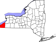
Towns Villages Bemus Point | Brocton | Cassadaga | Celoron | Cherry Creek | Falconer | Forestville | Fredonia | Lakewood | Mayville | Panama | Sherman | Silver Creek | Sinclairville | Westfield
CDPs Other
hamletsIndian
reservationCategories:- Towns in New York
- Populated places established in 1820
- 1820 establishments in the United States
- Populated places in Chautauqua County, New York


Wikimedia Foundation. 2010.