- Mount Hope, Providence, Rhode Island
-
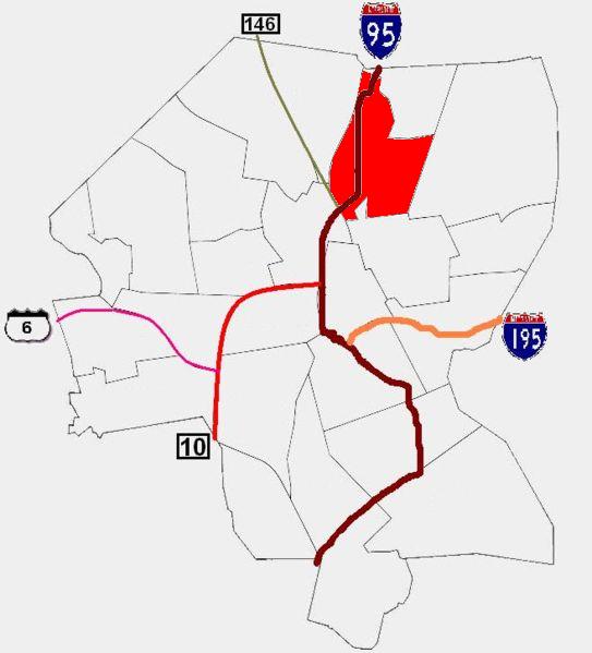
 Providence neighborhoods with Mount Hope in red
Mount Hope is a neighborhood in northern Providence, Rhode Island. It is one of six neighborhoods comprising the East Side of Providence. The area is bounded to the north by Rochambeau Avenue, to the east by Hope Street, to the south by Olney Street, while the western border is the former New York-New Haven Railroad (now Amtrak and MBTA)[1][2] and Interstate 95[3]. Camp Street is often used as a landmark for the neighborhood, as it runs lengthwise through Mount Hope's center.
The neighborhood is 44.5% non-Hispanic White, 29.4% African-American, and 10.4% Hispanic. Median household income is $28,413, and median family income is $35,476. 24.0% of families live below the poverty line.[4]
References
- ^ "USGS Providence topographic quadrangle". TopoQuest.com. http://www.topoquest.com/map.asp?lat=41.84523&lon=-71.4146&datum=nad83&layer=DRG. Retrieved 2008-07-05.
- ^ MBTA > Schedules & Maps > Commuter Rail > Providence "Schedules & Maps". Massachusetts Bay Transportation Authority. http://mbta.com/schedules_and_maps/rail/lines/stations/?stopId=163 MBTA > Schedules & Maps > Commuter Rail > Providence. Retrieved 2007-12-29.
- ^ ""Mount Hope Neighborhood Profile"". Providenceri.com. http://www.providenceri.com/Neighborhoods/mnthope.html. Retrieved 2007-12-29.
- ^ http://local.provplan.org/profiles/mth_main.html
Official neighborhoods Blackstone · Charles · College Hill · Downtown · Elmhurst · Elmwood · Federal Hill · Fox Point · Hartford · Hope · Lower South Providence · Manton · Mount Hope · Mount Pleasant · Olneyville · Reservoir · Silver Lake · Smith Hill · South Elmwood · Upper South Providence · Valley · Wanskuck · Washington Park · Wayland · West EndAgglomerations Categories:- Neighborhoods in Providence, Rhode Island
- Rhode Island geography stubs
Wikimedia Foundation. 2010.