- Estell Manor, New Jersey
Infobox Settlement
official_name = Estell Manor, New Jersey
settlement_type =City (New Jersey)
nickname =
motto =
imagesize =
image_caption =
image_
imagesize =
image_caption =
image_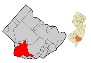
mapsize = 250x200px
map_caption = Map of Estell Manor in Atlantic County. Inset: Location of Atlantic County highlighted in the State of New Jersey.
mapsize1 = 250x200px
map_caption1 = Census Bureau map of Estell Manor, New Jerseysubdivision_type = Country
subdivision_name =United States
subdivision_type1 = State
subdivision_name1 =New Jersey
subdivision_type2 = County
subdivision_name2 = Atlantic
government_footnotes =
government_type =Faulkner Act (Small Municipality)
leader_title =Mayor
leader_name = Joseph Venizia
leader_title1 = Administrator
leader_name1 = Dawn Gorman
established_title = Incorporated
established_date =March 14 ,1925 unit_pref = Imperial
area_footnotes =
area_magnitude =
area_total_km2 = 142.2
area_land_km2 = 138.7
area_water_km2 = 3.5
area_total_sq_mi = 54.9
area_land_sq_mi = 53.6
area_water_sq_mi = 1.3population_as_of = 2007
population_footnotes =
population_total = 1714
population_density_km2 = 11.4
population_density_sq_mi = 29.6timezone = Eastern (EST)
utc_offset = -5
timezone_DST = EDT
utc_offset_DST = -4
elevation_footnotes = [Gnis|885212|City of Estell Manor,Geographic Names Information System , accessedJanuary 4 ,2008 .]
elevation_m = 14
elevation_ft = 46
latd = 39 |latm = 21 |lats = 15 |latNS = N
longd = 74 |longm = 46 |longs = 24 |longEW = Wpostal_code_type =
ZIP code
postal_code = 08319
area_code = 609
blank_name = FIPS code
blank_info = 34-21870GR|2 [ [http://mcdc2.missouri.edu/webrepts/commoncodes/ccc_nj.html A Cure for the Common Codes: New Jersey] , Missouri Census Data Center. AccessedJuly 14 ,2008 .]
blank1_name = GNIS feature ID
blank1_info = 0885212GR|3
website =
footnotes =Estell Manor is a city in Atlantic County,
New Jersey ,United States . As of theUnited States 2000 Census , the city population was 1,585.Estell Manor was incorporated as a city by an Act of the
New Jersey Legislature onMarch 14 ,1925 , from portions of Weymouth Township."The Story of New Jersey's Civil Boundaries: 1606-1968", John P. Snyder, Bureau of Geology and Topography; Trenton, New Jersey; 1969. p. 69.]Geography
Estell Manor is located at coor dms|39|22|29|N|74|46|17|W|city (39.374822, -74.771300)GR|1.
According to the
United States Census Bureau , the city has a total area of 54.9square mile s (142.2km² ), of which, 53.6 square miles (138.7 km²) of it is land and 1.3 square miles (3.5 km²) of it (2.44%) is water.Demographics
USCensusPop
1930= 423
1940= 406
1950= 381
1960= 496
1970= 539
1980= 848
1990= 1404
2000= 1585
estimate=1714
estyear=2007
estref= [http://factfinder.census.gov/servlet/SAFFPopulation?_event=Search&geo_id=16000US3420350&_geoContext=01000US%7C04000US34%7C16000US3420350&_street=&_county=estell+manor&_cityTown=estell+manor&_state=&_zip=&_lang=en&_sse=on&ActiveGeoDiv=geoSelect&_useEV=&pctxt=fph&pgsl=160&_submenuId=population_0&ds_name=null&_ci_nbr=null&qr_name=null®=null%3Anull&_keyword=&_industry= Census data for Estell Manor] ,United States Census Bureau , accessedSeptember 3 ,2008 .]
footnote=Population 1930 - 1990 [ [http://www.wnjpin.net/OneStopCareerCenter/LaborMarketInformation/lmi01/poptrd6.htm New Jersey Resident Population by Municipality: 1930 - 1990] , Workforce New Jersey Public Information Network. AccessedMarch 1 ,2007 .] As of thecensus GR|2 of 2000, there were 1,585 people, 528 households, and 432 families residing in the city. Thepopulation density was 29.6 people per square mile (11.4/km²). There were 546 housing units at an average density of 10.2/sq mi (3.9/km²). The racial makeup of the city was 94.20% White, 3.60% African American, 0.44% Native American, 0.32% Asian, 0.13% from other races, and 1.32% from two or more races. Hispanic or Latino of any race were 0.95% of the population.There were 528 households out of which 41.1% had children under the age of 18 living with them, 71.0% were married couples living together, 7.4% had a female householder with no husband present, and 18.0% were non-families. 13.8% of all households were made up of individuals and 6.8% had someone living alone who was 65 years of age or older. The average household size was 2.95 and the average family size was 3.27.
In the city the population was spread out with 30.2% under the age of 18, 6.5% from 18 to 24, 30.1% from 25 to 44, 23.6% from 45 to 64, and 9.7% who were 65 years of age or older. The median age was 37 years. For every 100 females there were 101.9 males. For every 100 females age 18 and over, there were 101.6 males.
The median income for a household in the city was $54,653, and the median income for a family was $56,548. Males had a median income of $42,305 versus $29,219 for females. The
per capita income for the city was $19,469. About 4.9% of families and 4.9% of the population were below thepoverty line , including 4.9% of those under age 18 and 7.1% of those age 65 or over.Government
Local government
Estell Manor operates under the
Faulkner Act (Small Municipality) form of New Jersey municipal government, led by a five-member City Council. Members of the City Council are elected at-large in partisan elections to serve three-year terms in office on a staggered basis."2005 New Jersey Legislative District Data Book",Rutgers University Edward J. Bloustein School of Planning and Public Policy , April 2005, p. 13.]The Mayor of the City of Estell Manor is Joseph Venizia. Members of the Estell Manor City Council are Albert Barbetto, Sandra Lampkin, Alberta Mossey and Creed Pogue. [ [http://www.acbiz.org/Main/About/ECD_about_local_gov.asp Municipal Governments in Atlantic County] ,
Atlantic County, New Jersey . AccessedMay 5 ,2008 .]Federal, state and county representation
Estell Manor is in the Second Congressional District and is part of New Jersey's 2nd Legislative District. [ [http://www.lwvnj.org/pubs/CG06.pdf 2006 New Jersey Citizen's Guide to Government] , New Jersey
League of Women Voters , p. 57. AccessedAugust 30 ,2006 .]Education
For grades K - 8, public school students attend the
Estell Manor City School District . Estell Manor Elementary School had an enrollment of 226 students as of the 2005-06 school year. [ [http://nces.ed.gov/ccd/schoolsearch/school_list.asp?Search=1&DistrictID=3404860 Data for the Estell Manor School] ,National Center for Education Statistics . AccessedMarch 14 ,2008 .]For grades 9 - 12, public school students attend
Buena Regional High School , which serves students from Buena Borough and Buena Vista Township, together with students from Estell Manor City, Newfield and Weymouth Township who attend the school as part ofsending/receiving relationship s. [ [http://education.state.nj.us/rc/rc07/narrative/01/0590/01-0590-000.html Buena Regional School District 2007 Report Card Narrative] ,New Jersey Department of Education . AccessedMarch 14 ,2008 . "Students from Weymouth and Estell Manor join students from Buena Vista Township, Buena Borough, and Newfield at the high school."] The high school is part of theBuena Regional School District .Transportation
Route 49 and Route 50 both pass through Estell Manor, as do County Route 557, County Route 649 and County Route 666.
References
External links
* [http://www.estellmanorschool.org/ Estell Manor School]
*NJReportCard|01|1410|050|Estell Manor School
* [http://nces.ed.gov/ccd/schoolsearch/school_list.asp?Search=1&DistrictID=3404860 Data for the Estell Manor School] ,National Center for Education Statistics
* [http://www.buena.k12.nj.us/Schools/BRHS/index.html Buena Regional High School]
Wikimedia Foundation. 2010.