- Northfield, New Hampshire
-
Northfield, New Hampshire — Town — Hall Memorial Library c. 1905

SealLocation in Merrimack County, New Hampshire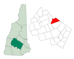
Coordinates: 43°26′15″N 71°35′35″W / 43.4375°N 71.59306°WCoordinates: 43°26′15″N 71°35′35″W / 43.4375°N 71.59306°W Country United States State New Hampshire County Merrimack Incorporated 1780 Government – Board of Selectmen Geoffrey Ziminsky, Chair
Stephen Bluhm
Lisa SwancottArea – Total 29.0 sq mi (75.2 km2) – Land 28.8 sq mi (74.6 km2) – Water 0.3 sq mi (0.7 km2) 0.89% Elevation 440 ft (134 m) Population (2010) – Total 4,829 – Density 166.5/sq mi (64.3/km2) Time zone Eastern (UTC-5) – Summer (DST) Eastern (UTC-4) Area code(s) 603 FIPS code 33-54260 GNIS feature ID 0873686 Website www.northfieldnh.org Northfield is a town in Merrimack County, New Hampshire, United States. The population was 4,829 at the 2010 census.[1]
Contents
History
The area was settled in 1760 as a part of Canterbury. In the late 1770s the residents of the "north fields" of Canterbury petitioned the State Legislature to become their own town, citing the difficulty of traveling to the town center to conduct business. In 1780 their petition was approved and the town of Northfield was created. Northfield has an uneven surface with some hills, the soil on which proved the most productive. Farming became the principal occupation. In 1848, the Boston, Concord and Montreal Railroad opened to Northfield, helping it develop symbiotically with Tilton across the river as a mill town. The Winnipesaukee River provided water power for mills, and by 1859, when the population was 1,332, Northfield had a woolen factory and a wrapping paper mill.[2]
Geography
According to the United States Census Bureau, the town has a total area of 29.0 square miles (75.1 km2), of which 28.8 sq mi (74.6 km2) is land and 0.3 sq mi (0.8 km2) is water, comprising 0.89% of the town. It is drained by Williams Brook and the Winnipesaukee River. The highest point in Northfield is the summit of Bean Hill at 1,500 feet (460 m) above sea level, in the southern part of town.
The town is served by Interstate 93 and state routes 132 and 140.
Demographics
 Tilton Memorial Arch (1882) in Arch Hill Park in Northfield, offering a commanding view of the area.
As of the census[3] of 2000, there were 4,548 people, 1,706 households, and 1,211 families residing in the town. The population density was 158.0 people per square mile (61.0/km²). There were 1,782 housing units at an average density of 61.9 per square mile (23.9/km²). The racial makeup of the town was 98.18% White, 0.13% African American, 0.18% Native American, 0.42% Asian, 0.15% from other races, and 0.95% from two or more races. Hispanic or Latino of any race were 0.92% of the population.
There were 1,706 households out of which 38.1% had children under the age of 18 living with them, 53.6% were married couples living together, 11.5% had a female householder with no husband present, and 29.0% were non-families. 20.2% of all households were made up of individuals and 7.1% had someone living alone who was 65 years of age or older. The average household size was 2.63 and the average family size was 3.03.
In the town the population was spread out with 27.9% under the age of 18, 7.8% from 18 to 24, 32.0% from 25 to 44, 23.6% from 45 to 64, and 8.7% who were 65 years of age or older. The median age was 36 years. For every 100 females there were 98.9 males. For every 100 females age 18 and over, there were 95.4 males.
The median income for a household in the town was $44,333, and the median income for a family was $48,787. Males had a median income of $33,051 versus $25,000 for females. The per capita income for the town was $18,466. About 0.9% of families and 3.9% of the population were below the poverty line, including 0.4% of those under age 18 and 7.5% of those age 65 or over.
Notable inhabitants
- Jillian Beyor, model
- Joseph Libbey Folsom, army officer and real estate investor
- Richard S. Molony, congressman
- Robert Smith, congressman
References
- ^ United States Census Bureau, American FactFinder, 2010 Census figures. Retrieved March 23, 2011.
- ^ Coolidge, Austin J.; John B. Mansfield (1859). A History and Description of New England. Boston, Massachusetts. p. 604. http://books.google.com/books?id=OcoMAAAAYAAJ&lpg=PA9&dq=coolidge%20mansfield%20history%20description%20new%20england%201859&pg=PA604#v=onepage&q&f=false.
- ^ "American FactFinder". United States Census Bureau. http://factfinder.census.gov. Retrieved 2008-01-31.
External links
- Town website
- Hall Memorial Library
- Arch Trail Travelers Snowmobile Club
- New Hampshire Economic and Labor Market Information Bureau Profile
Municipalities and communities of Merrimack County, New Hampshire Cities 
Towns Allenstown | Andover | Boscawen | Bow | Bradford | Canterbury | Chichester | Danbury | Dunbarton | Epsom | Henniker | Hill | Hooksett | Hopkinton | Loudon | New London | Newbury | Northfield | Pembroke | Pittsfield | Salisbury | Sutton | Warner | Webster | Wilmot
Villages Blodgett Landing | Contoocook | East Andover | Elkins | Penacook | South Hooksett | Suncook | Tilton-Northfield‡
Footnotes ‡This populated place also has portions in an adjacent county or counties
Categories:- Towns in Merrimack County, New Hampshire
- Populated places established in 1780


Wikimedia Foundation. 2010.