- Desert National Wildlife Refuge
-
Coordinates: 36°46′00″N 115°26′00″W / 36.7666667°N 115.4333333°W
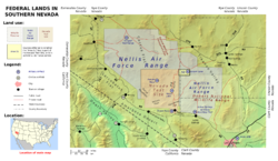 Map showing the Desert National Wildlife Reserve and other federal properties in southern Nevada
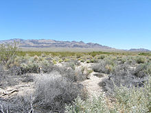 Desert Environment in the Desert National Wildlife Refuge
The Desert National Wildlife Range is a protected wildlife refuge, administered by the U.S. Fish and Wildlife Service, located north of Las Vegas, Nevada, in northwestern Clark and southwestern Lincoln counties, with much of its land area lying within the southeastern section of the Nevada Test and Training Range. The Desert NWR, created on May 20, 1936, is the largest wildlife refuge in the lower 48 states of the United States,[1] encompassing 1.615 million acres (6,537 km²) of the Mojave Desert in the southern part of Nevada.[2] This Range is part of the larger Desert National Wildlife Refuge Complex, which includes the Ash Meadows National Wildlife Refuge, Moapa Valley National Wildlife Refuge, Pahranagat National Wildlife Refuge, and the Amargosa Pupfish Station.
Contents
Description of refuge
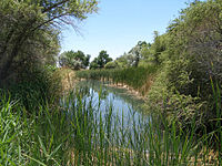 Corn Creek Springs at Desert National Wildlife Refuge
Range/Refuge staff work out of the Corn Creek Field Station, which includes a visitors center, which is located 23 miles (37 km) north of Las Vegas, Nevada. The Range can be accessed from U.S. 95 North.
The Desert NWR contains six major mountain ranges, including the Sheep Range, with heights up to 10,000 feet (3,000 m) and valleys around 2,500 feet (800 m). Annual rainfall in the range varies from less than four inches (102 mm) in the valleys to over fifteen inches (381 mm) on the mountain peaks.
Perpetuating the desert bighorn sheep and its habitat is the most important objective of the range. The Range actively improves bighorn habitats by developing new water sources and maintaining and improving existing ones. Numerous other wildlife species share the range with bighorns.
In addition to wildlife the Range also boasts an abundance of plant communities. Plant communities and wildlife found on the Range vary with altitude and climate. Most of these plant species can be seen while driving the Morman Well Road (which can be accessed from the Corn Creek Field Station). The desert shrub community, composed of creosote bush and white bursage are the dominant shrubs in the hottest, lowest elevations of Desert National Wildlife Range. Above the valley floor, Mojave yucca and cactus become abundant. At the upper edge of the desert shrub communities, between approximately 4,200 to 6,000 feet (1300 to 1800 m), black-brush and Joshua tree are dominant. Above 6,000 feet (1800 m) desert woodlands, composed of single-leaf pinyon, Utah juniper, and big sagebrush begin. The coniferous forest communities begin around 7,000 feet (2100 m). From 7,000 to 9,000 feet (2100 to 2700 m) Ponderosa pine and white fir are the dominant trees. Near 10,000 feet (3,000 m) where the growing seasons are the shortest, the only trees surviving are bristlecone pines.
Numerous recreational opportunities are available on the Range. Camping, hiking, backpacking, and horseback riding are all popular activities enjoyed by refuge visitors. Limited hunting for bighorn sheep is permitted. Please contact the Refuge Manager for additional information.
Although it is the largest National Wildlife Refuge in the Lower 48 states, there are eleven larger ones in the state of Alaska.
See also
References
- ^ Green, Jason C. (2007-11-16). "Groups criticize energy corridors". Las Vegas Review-Journal (Stephens Media).
- ^ USFWS Annual Lands Report, 30 September 2007
External links
- U.S. Fish and Wildlife Service, Desert National Wildlife Range Page
- U.S. Fish and Wildlife Service, Desert National Wildlife Refuge Complex
Categories:- Desert National Wildlife Refuge Complex
- National Wildlife Refuges in Nevada
- Protected areas of Clark County, Nevada
- Protected areas of Lincoln County, Nevada


Wikimedia Foundation. 2010.