- Melstone, Montana
-
Melstone, Montana — Town — Location of Melstone, Montana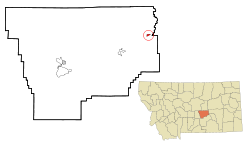
Coordinates: 46°35′57″N 107°52′11″W / 46.59917°N 107.86972°WCoordinates: 46°35′57″N 107°52′11″W / 46.59917°N 107.86972°W Country United States State Montana County Musselshell Area – Total 0.7 sq mi (1.8 km2) – Land 0.7 sq mi (1.8 km2) – Water 0.0 sq mi (0.0 km2) Elevation 2,940 ft (896 m) Population (2000) – Total 136 – Density 198.8/sq mi (76.8/km2) Time zone Mountain (MST) (UTC-7) – Summer (DST) MDT (UTC-6) ZIP code 59054 Area code(s) 406 FIPS code 30-49000 GNIS feature ID 0774093 Melstone is a town in far eastern Musselshell County, Montana, United States, along U.S. Route 12. The population was 136 at the 2000 census. The town was established in 1908 as a base for operating crews on the Chicago, Milwaukee, St. Paul and Pacific Railroad, then under construction in Montana. Although the railroad was abandoned in 1980, Melstone survives as a community center for farmers and ranchers in the lower Musselshell River valley.
Contents
Geography
Melstone is located at 46°35′57″N 107°52′11″W / 46.59917°N 107.86972°W (46.599081, -107.869851)[1].
According to the United States Census Bureau, the town has a total area of 0.7 square miles (1.8 km2), all of it land.
Demographics
As of the census[2] of 2000, there were 136 people, 56 households, and 38 families residing in the town. The population density was 198.8 people per square mile (77.2/km²). There were 87 housing units at an average density of 127.2 per square mile (49.4/km²). The racial makeup of the town was 95.59% White, 0.74% Native American, 0.74% Asian, 1.47% from other races, and 1.47% from two or more races. Hispanic or Latino of any race were 1.47% of the population.
There were 56 households out of which 28.6% had children under the age of 18 living with them, 53.6% were married couples living together, 10.7% had a female householder with no husband present, and 32.1% were non-families. 30.4% of all households were made up of individuals and 16.1% had someone living alone who was 65 years of age or older. The average household size was 2.43 and the average family size was 3.03.
In the town the population was spread out with 25.7% under the age of 18, 6.6% from 18 to 24, 25.0% from 25 to 44, 27.2% from 45 to 64, and 15.4% who were 65 years of age or older. The median age was 41 years. For every 100 females there were 86.3 males. For every 100 females age 18 and over, there were 90.6 males.
The median income for a household in the town was $31,250, and the median income for a family was $33,438. Males had a median income of $36,250 versus $12,083 for females. The per capita income for the town was $15,027. There were no families and 5.8% of the population living below the poverty line, including no under eighteens and 10.7% of those over 64.
Current events
In 2006, Melstone made history by winning the State Boys Basketball Championship, being the smallest school ever to win. The Melstone Broncs defeated the defending state champion Gardiner Bruins in an overtime win.[3] The Broncs won 83-78 for the Class C boys basketball crown at MetraPark Arena in Billings, Montana.
2008 marked the town's centennial.
Notable residents
- Evelyn Genevieve Sharp, early American aviatrix.
References
- ^ "US Gazetteer files: 2010, 2000, and 1990". United States Census Bureau. 2011-02-12. http://www.census.gov/geo/www/gazetteer/gazette.html. Retrieved 2011-04-23.
- ^ "American FactFinder". United States Census Bureau. http://factfinder.census.gov. Retrieved 2008-01-31.
- ^ http://billingsgazette.com/sports/article_01dd47b5-a53e-5a69-87ee-78cfdb2b9640.html
Municipalities and communities of Musselshell County, Montana City 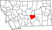
Town Melstone
CDPs Categories:- Populated places in Musselshell County, Montana
- Towns in Montana


Wikimedia Foundation. 2010.