- New York State Route 146B
-
NYS Route 146B

Map of the Schenectady area with NY 146B highlighted in redRoute information Auxiliary route of NY 146 Maintained by State of New York Department of Public Works Length: 3.05 mi[5] (4.91 km) Existed: ca. 1932[1][2] – ca. 1965[3][4] Major junctions West end:  NY 146 in Clifton Park
East end: Miller and Sugarhill Roads in Clifton Park Location Counties: Saratoga Highway system Numbered highways in New York
Interstate • U.S. • N.Y. (former) • Reference • County←  NY 146A
NY 146C  →
→New York State Route 146B (NY 146B) was a state highway in southern Saratoga County, New York, United States. It was 3 miles (4.8 km) long and located entirely within the town of Clifton Park. The western terminus of the route was at an intersection with NY 146, its parent route, in the hamlet of Rexford. The eastern terminus of NY 146B was in the hamlet of Groom Corners, where it met Miller and Sugarhill Roads. NY 146B was assigned ca. 1932 and removed ca. 1965. Its former routing is now the western portion of County Route 91 (CR 91).
Contents
Route description
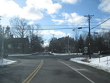 Former western terminus of NY 146B at NY 146 in Rexford
NY 146B began at an intersection with NY 146 in Rexford, a small riverside hamlet in the town of Clifton Park. The route headed southeastward on Riverview Road, following the northern bank of the Mohawk River (also part of the Erie Canal) through the town. It passed to the south of the Edison Country Club and remained on the riverbank to an intersection with Grooms Road approximately 1 mile (1.6 km) southeast of Rexford. Here, NY 146B turned eastward to follow Grooms Road to the hamlet of Groom Corners, a community based around the intersection of Grooms, Miller and Sugarhill Roads. NY 146B ended at this junction; however, Grooms Road continued eastward to a junction with U.S. Route 9 (US 9) in the town of Halfmoon.[5][3]
History
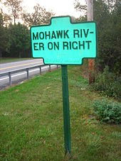 An old, embossed sign on CR 91, a remnant of the state highway designation
On July 11, 1916, the state of New York let a contract for improving a series of roadways linking Groom Corners to Waite Corners by way of Rexford Flats (now Rexford). Approximately half of the project was complete by 1920,[6] while the remainder was completed over the next few years.[citation needed] In the 1930 renumbering of state highways in New York, the portion of the Groom Corners – Waite Corners highway from Rexford to Waite Corners became part of the new NY 146.[7] The remainder of the highway from Rexford to Groom Corners was designated as NY 146B, a spur route of NY 146, ca. 1932.[1][2] NY 146B remained unchanged until ca. 1965, when the designation was removed from the highway.[3][4] The former routing of NY 146B is now part of CR 91, which continues eastward on Grooms Road to meet US 9 in the town of Halfmoon.[5] Additionally, the Riverview Road portion of old NY 146B is now part of the Mohawk Towpath Scenic Byway, a National Scenic Byway.[8]
Major intersections
The entire route was in Clifton Park, Saratoga County.
Mile[5] Destinations Notes 0.00 NY 146Hamlet of Rexford 3.05 Miller Road / Sugarhill Road Hamlet of Groom Corners 1.000 mi = 1.609 km; 1.000 km = 0.621 mi References
- ^ a b Kendall Refining Company (1931). New York (Map). Cartography by H.M. Gousha Company.
- ^ a b Texas Oil Company (1932). Texaco Road Map – New York (Map). Cartography by Rand McNally and Company.
- ^ a b c Standard Oil Company (1964-65). New York State Map (Map).
- ^ a b Mobil Service (1965). New York (Map). Cartography by Rand McNally.
- ^ a b c d Yahoo! Inc. Yahoo! Maps – overview map of former NY 146B (Map). Cartography by NAVTEQ. http://maps.yahoo.com/#mvt=m&lat=42.845535&lon=-73.866245&zoom=15&q1=42.85613%2C-73.888641&q2=42.83508%2C-73.843794. Retrieved July 27, 2009.
- ^ New York State Department of Highways (1920). Report of the State Commissioner of Highways. Albany, New York: J. B. Lyon Company. pp. 254, 448. http://books.google.com/books?id=8dANAAAAYAAJ&pg=PA254. Retrieved July 27, 2009.
- ^ Standard Oil Company of New York (1930). Road Map of New York (Map). Cartography by General Drafting.
- ^ "Mohawk Towpath Scenic Byway". United States Department of Transportation. 2008. http://www.byways.org/explore/byways/57185/travel.html. Retrieved September 22, 2008.
External links
Categories:- Former state highways in New York
- Transportation in Saratoga County, New York


Wikimedia Foundation. 2010.