- California State Route 905
-
State Route 905
Route information Defined by S&HC § 632 Maintained by Caltrans Length: 8.964 mi[3] (14.426 km) Existed: October 1984 by FHWA[1]
1986 by Caltrans (from SR 117)[2] – presentMajor junctions West end:  I-5 in San Diego
East end: Mexican border near Otay Mesa Highway system State highways in California(list • pre-1964)
History • Unconstructed • Deleted • Freeway • Scenic←  I-880
I-880I-980  →
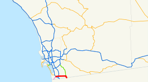
→State Route 905 (SR 905) is a state highway in San Diego, California that connects Interstate 5 and Interstate 805 in San Ysidro to the United States – Mexico border at Otay Mesa. The portions of the route from I-5 to I-805 and from Britannia Boulevard to the International border are freeway. The remainder of the route is an expressway known as Otay Mesa Road.
The entire route is currently being upgraded to Interstate standards. Once completed, it will become Interstate 905. This route is part of the California Freeway and Expressway System.[4]
Contents
Route description
SR 905 begins at the intersection of Tocayo Avenue and Oro Vista Road in San Ysidro. It begins as a freeway, intersecting with I-5 and then I-805 after a few exits. Following this, SR 905 intersects Otay Mesa Road at an at-grade intersection. SR 905 becomes Otay Mesa Road and heads east as a highway past Brown Field. The route temporarily turns south on Britannia Boulevard for a short distance to connect to a new freeway segment (via a partially completed interchange) parallel to Otay Mesa Road. At this point, SR 905 turns east onto the new freeway segment, with a interchange at La Media Road. The route turns southeast to its final interchange at Siempre Viva Road. Following this, SR 905 ends at the Mexican border.[5]
Previously, SR 905 had a direct connection with SR 125 via two at-grade intersections on Otay Mesa Road. With the completion of the newest freeway segment of SR 905 and the freeway-to-freeway connection to SR 125 unconstructed, eastbound traffic on SR 905 can continue on Otay Mesa Road past Britannia Boulevard to make the connection, while westbound traffic must exit at La Media Road (exit 7), head north on La Media and head east on Otay Mesa Road to make the connection. A freeway-to-freeway interchange is planned for the connection between SR 125 and SR 905; this interchange will be built when the new SR 11 freeway is constructed. SR 11 will be a toll facility that will serve a new border crossing east of Otay Mesa.
The final freeway segment of SR 905 between I-805 and Britannia Boulevard is scheduled for completion in 2012.[6]
History
The majority of SR 905, paralleling Otay Mesa Road from I-5 to SR 125, was added to the state highway system and California Freeway and Expressway System in 1959 as Legislative Route 281,[7] and became part of State Route 75 in the 1964 renumbering.[8] In 1972, the legislature added a new State Route 117, which extended this part of SR 75 southwest to the Mexican border near Border Field State Park, to the state highway system, and a southerly extension of SR 125 to the border at Otay Mesa to the state highway and Freeway and Expressway systems.[9] SR 117 was extended east to SR 125, replacing this southerly segment of SR 75, in 1976.[10] The Federal Highway Administration approved the continuous roadway via SR 117 and SR 125 from I-5 to the border at Otay Mesa as a non-chargeable (not eligible for federal interstate construction dollars) part of the Interstate Highway System in October 1984,[11] and the number was legislatively changed to 905 in 1986.[12] The original piece of SR 117 (west of I-5), which is not part of the Interstate Highway or California Freeway and Expressway Systems, also became SR 905, but Caltrans has no plans to construct it.[citation needed]
Future
Future Interstate 905

Location: San Diego In February 2008, multinational construction group Skanska announced they had been awarded a contract by Caltrans to construct a freeway along Route 905 between I-805 and State Route 125[13]:
The project comprises new construction of about four kilometers (2.5 mi) of six-lane freeway. Construction will require major grading operations for the base and 103,000 tons of asphalt. The contract also covers five bridges, landscaping, storm drains and irrigation system as well as all installations of signal and safety systems.
Once the highway has been fully upgraded to Interstate standards, it will become Interstate 905 and it will connect to State Route 125. Once designated, it will become only the third auxiliary three-digit Interstate to meet an international border (the other two being Interstate 190 in New York and Interstate 110 in Texas) and the second to touch the United States-Mexico border. It will also be only the second purely east-west Interstate to connect with a foreign country, after Interstate 94, which connects with Canada.
Exit list
Note: Except where prefixed with a letter, postmiles were measured on the road as it was in 1964, and do not necessarily reflect current mileage.
The entire route is in San Diego, San Diego County.
Postmile
[3][14][15]Exit
[16]Destinations Notes 2.84 Oro Vista Road, Tocayo Avenue At-grade intersection 3.19 1 I-5 – San Diego, Los AngelesSigned as exits 1A (north) and 1B (south); no exit numbers eastbound 3.82 1C Beyer Boulevard Signed as exit 1 eastbound 4.41 2A Picador Boulevard, Smythe Avenue 5.16 2B  I-805 (Jacob Dekema Freeway)
East end of freeway  Otay Mesa Road to SR 125 north (South Bay Expressway)
Former SR 905 east West end of freeway 6 Britannia Boulevard SR 905 currently uses Britannia Boulevard between the old and new alignments 7 La Media Road 8 SR 125 north (South Bay Expressway)Proposed interchange; currently accessible via exit 7 11.60 9 Siempre Viva Road Last USA exit eastbound 11.80 Mexico – United States border 1.000 mi = 1.609 km; 1.000 km = 0.621 mi
Concurrency terminus • Closed/Former • Incomplete access • UnopenedReferences
- ^ California Highways: Interstate Highway Types and the History of California's Interstates
- ^ California Highways: State Route 905
- ^ a b California Department of Transportation, State Truck Route List (XLS file), accessed February 2008
- ^ CA Codes (shc:250-257)
- ^ Thomas Brothers (2009). San Diego County Street Atlas (Map).
- ^ "New Stretch Of SR-905 Ready To Open". 10 November 2010. http://www.10news.com/news/25752603/detail.html. Retrieved 02 March 2011
- ^ "An act to amend...the Streets and Highways Code, relating to state highways, providing for a California Freeway and Expressway System...", 1959 chapter 1062, p. 3115, 3121: "Route 281 is from Route 2 [I-5] near the south end of San Diego Bay to east of United States Naval Auxiliary Air Station, Brown Field."
- ^ "An act...relating to routes on the state highway system.", 1963 chapter 385, p. 1177: "Route 75 is from: (a) Route 125 east of Brown Field to Route 5 near the south end of San Diego Bay..."
- ^ "An act to amend...the Streets and Highways Code, relating to state highways.", 1972 chapter 1216, p. 2345, 2351: "Route 117 is from the international boundary near Borderfield [sic] northeasterly to Route 5." "Route 125 is from: (a) The international boundary southerly of Brown Field to Route 54..."
- ^ "An act to amend...the Streets and Highways Code, relating to state highways.", 1976 chapter 1354, p. 6177: "Route 117 is from:...(b) Route 5 near the south end of San Diego Bay to Route 125 near Brown Field."
- ^ California Department of Transportation, State Highway Routes: Selected Information, 1994 with 1995 revisions
- ^ "An act to amend...the Streets and Highways Code, relating to state highways.", 1986 chapter 928, p. 3216: "Route 905 is from: (a) The International Boundary near Border Field northeasterly to Route 5. (b) Route 5 near the south end of San Diego Bay to the International Boundary southerly of Brown Field."
- ^ Skanska press release, February 2008
- ^ California Department of Transportation, Log of Bridges on State Highways, July 2007
- ^ California Department of Transportation, All Traffic Volumes on CSHS, 2005 and 2006
- ^ California Department of Transportation, California Numbered Exit Uniform System, State Route 905 Freeway Interchanges, Retrieved on 2009-02-07.
External links
Auxiliary routes of Interstate 5 California: 105 • 105 (former) • 205 • 305 (unsigned) • 405 • 505 • 605 • 805 • 905 (future) — Oregon: 105 • 205 • 305 (unbuilt) • 405 • 505 (unbuilt) — Washington: 205 • 405 • 605 (unbuilt) • 705
Interstate Highways in California Signed Unsigned 305 • 905 (future)Business Loops Former Categories:- State highways in California
- Southern California freeways
- Roads in San Diego County, California


Wikimedia Foundation. 2010.