- Cockayne Hatley
-
Coordinates: 52°07′49″N 0°09′39″W / 52.1304°N 0.1607°W
Cockayne Hatley 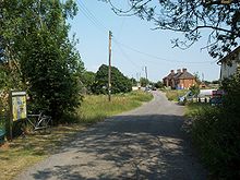

The far end of the village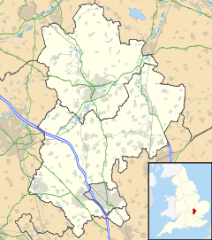
 Cockayne Hatley
Cockayne Hatley shown within BedfordshirePopulation 75 OS grid reference TL260496 Parish Wrestlingworth and Cockayne Hatley Unitary authority Central Bedfordshire Ceremonial county Bedfordshire Region East Country England Sovereign state United Kingdom Post town Sandy Postcode district SG19 Police Bedfordshire Fire Bedfordshire and Luton Ambulance East of England EU Parliament East of England List of places: UK • England • Bedfordshire Cockayne Hatley is a small village in Bedfordshire dating back to Saxon times (population 2007 approximately 75 with 33 houses), bordering on Cambridgeshire, 3 miles (5 km) east of Potton, 6 miles (10 km) north-east from Biggleswade and 9 miles (15 km) south-east from St. Neots. The village's population in 1891 was 104.
The soil is strong clay with clay subsoil. The chief crops are wheat, oil seed rape, beans and peas. The farmland surrounding the village covers an area of 587 hectares and belongs to a Danish family-owned business which grows produce for its own retail operations across Europe.
Cockayne Hatley Hall
Cockayne Hatley Hall, once known as Cockayne Hatley Mansion, was originally established by Sir John Cockayne in the 14th century. The Hall has been added to and rebuilt many times. The main parts of the present building are early Victorian with the East wing dating back to the reign of George I. There is still a single wall and fireplace dating back to Tudor times.
The Cockayne family continued to reside at the Hall until the late 1860s. Several families took on the Hall and the Estate until 1929 when Mr John Whitehead purchased the estate and eventually established the largest apple orchard in England with over one million Cox's Orange Pippin trees, until they were dug up and burned as uneconomic in 1974.[1]
A fire destroyed much of the south facing building in 1931. Although repaired, many of the grand rooms and architecture were lost. Mr Whitehead left the Hall shortly after the war selling the whole estate to the Co-op Farming group. Much of the property subsequently fell into disrepair before the Hall, together with some of the surrounding land, was sold back to private ownership. Now greatly restored, the Hall and the adjacent Church of John the Baptist reflect the affluence of its past history.
From 1894 to 1897 the Hall was rented by part of the "Old Family Line", the Duke of Rutland. His daughter, Lady Diana Manners, lived there as a young girl before going on to earn the widespread reputation as the most beautiful young woman in England, and appeared in countless profiles, photographs and articles in newspapers and magazines including the front page of Time magazine in February 1926.
St John's Church
The Church of St John the Baptist is situated at the gates of an ancient hall and dates to the thirteenth century. It contains numerous high quality works of carved wood and stained glass, mostly from the abbey of Alne near Charleroi. Dating from 1689, these works were "liberated" from Flanders following the Napoleonic wars by the Rev. Henry Cockayne Cust, parish rector from 1806 to 1861.[2]
The churchyard contains a handsome monument over the grave of the poet W. E. Henley, who was a frequent visitor to Cockayne Hatley Hall. Henley, who had a wooden leg, was Robert Louis Stephenson's model for Long John Silver. Henley was also a friend of J. M. Barrie, the author of Peter Pan. Henley used to address Barrie as "friend", which Henley's only daughter, Margaret (1888–1894), who is also buried there along with her parents, mispronounced as "fwend" and changed in a childish way to "fwendy-wendy".[3][4] The latter part of this familiar name gave the name of "Wendy Darling" which later became the Wendy of Peter Pan. Henley is now chiefly remembered as the author of the poem "Invictus".
References
- ^ "Cockayne Hatley Crops". http://www.galaxy.bedfordshire.gov.uk/webingres/bedfordshire/vlib/0.digitised_resources/cockaynehatley_digitisation_az_topics_appleorchards.htm. Retrieved 7 January 2009.
- ^ Encyclopedia Britannica, 1911
- ^ "The History of Wendy". http://www.wendy.com/wendyweb/history.html. Retrieved 2009-07-25.
- ^ Winn, Christopher. I Never Knew That About England.
 This article incorporates text from a publication now in the public domain: Chisholm, Hugh, ed (1911). Encyclopædia Britannica (11th ed.). Cambridge University Press.Categories:
- Villages in Bedfordshire


Wikimedia Foundation. 2010.