- Meeth Halt railway station
-
Meeth Halt 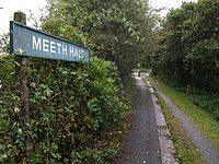
Site of old station, now part of a long distance footpath Location Place Meeth Area West Devon Grid reference SS546079 Operations Pre-grouping North Devon and Cornwall Junction Light Railway (1925 to 1948) Post-grouping Southern Region of British Railways (1948 to 1966) Platforms One History 27 July 1925 Opened 1 March 1965 Closed Disused railway stations in the United Kingdom Closed railway stations in Britain
A B C D–F G H–J K–L M–O P–R S T–V W–ZOpened in 1925, Meeth Halt was a small railway station on the North Devon and Cornwall Junction Light Railway, a private line until it became part of the Southern Region of British Railways in 1948.[1] The line was built in part over narrow gauge line that was used from 1881 to take ball clay from claypits at Marland and Meeth to Torrington, which was until 1925 the terminus of a branch from Barnstaple.
The line was closed to passenger traffic in 1965[2] as part of the Beeching proposals, but remained open for freight from the Meeth clay workings north of Meeth Halt through Torrington to Barnstaple up to 1982.[3] The station consisted of a simple short concrete platform and a stone shelter and remains as a recognisable landmark on the Tarka Trail, a very popular destination for long distance walkers and cyclists.[4] As a result, it is in the process of a major renovation.[5]
References
- ^ Branch Lines to Torrington Mitchell,V & Smith,K: Midhurst, Middleton Press,1994 ISBN 1-873793-37-5
- ^ "Discovering Britain's lost railways" Atterbury,P: Basingstoke, AA Publishing ISBN 0749563707
- ^ Freight details
- ^ Local authority details
- ^ Planning application
Preceding station Disused railways Following station Petrockstow North Devon and Cornwall Junction Light Railway (1925 to 1948)
Southern Region of British Railways (1948 to 1965)Hatherleigh See also
Ex stations on the North Devon and Cornwall Junction Light Railway Torrington • Watergate Halt • Yarde Halt • Dunsbear Halt • Marland Works • Petrockstow • Meeth Halt • Hatherleigh • Hole • Halwill
50°51′06″N 4°3′58″W / 50.85167°N 4.06611°WCoordinates: 50°51′06″N 4°3′58″W / 50.85167°N 4.06611°W
Categories:- Disused railway stations in Devon
- Railway stations opened in 1925
- Railway stations closed in 1965
- Beeching closures in England
- South West England railway station stubs

Wikimedia Foundation. 2010.