- Charsfield
-
Coordinates: 52°08′53″N 1°18′22″E / 52.148°N 1.306°E
Charsfield 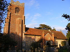
Church of St Peter, Charsfield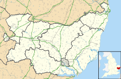
 Charsfield
Charsfield shown within SuffolkShire county Suffolk Region East Country England Sovereign state United Kingdom EU Parliament East of England List of places: UK • England • Suffolk Charsfield is a small Suffolk village of approximately 250 residents, 3 miles (4.8 km) from Wickham Market, 7 miles (11 km) miles from Woodbridge and 12 miles (19 km) miles from Ipswich and is located near the villages of Debach and Dallinghoo. A Civil Parish in East Anglia, Charsfield was famously used as one of the key locations in the 1974 film Akenfield, based loosely upon the book Akenfield: Portrait of an English Village by the historian Ronald Blythe (1969). Charsfield hosted the first Greenbelt festival - an annual festival of arts, faith and justice - on a pig farm just outside the village over the August 1974 bank holiday weekend. Famous Charsfield residents include Charles Webb, a respected Victorian architect and Peggy Cole, a frequent speaker on BBC's Radio Suffolk.
Contents
Local facilities
- Charsfield village hall
- Baptist Chapel
- Charsfield Primary School (linked to St Peter's church); famous alumni of the school include Charlotte Greig, a British novelist, singer, and song-writer.
- Charsfield recreation ground
- Garage
- St. Peter's Church (Church of England)
- Three Horse Shoes Pub
Charsfield Village Hall
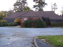

Charsfield Village Hall, (based in the small Suffolk village of Charsfield), was originally built during the 1930s as the result of a gift from W. H. Youngman. It has been in use ever since and is now owned by the Parish Council and managed by the Village Hall Management Committee. In recent years the hall has been enlarged at the back but more ambitious plans to bring it up to modern standards of comfort and convenience have been restricted by available funds.
During 1999 the Committee prepared plans for an ambitious extension and applied to the National Lottery Charities Board (now known as the Community Fund),[1] and in December of that year it was decided that the Village hall would receive a grant of over 90% of the monies needed. From June 2000 until December the hall was closed to allow the work to be undertaken by V. A. Marriott Ltd., which was completed on the 24th November of that year. The grand reopening of the hall took place on the 20th January 2001 by Mrs. Diane Youngman (a relative of W. H. Youngman - the original benefactor).
References
External links
- Charsfield village web site
- New Charsfield Village Hall Web site
- Charsfield School Website
- GENUKI
- Tourist Information
- CEVCP Admisions information
- Three Horse Shoes Pub
Towns Civil parishes Alderton · Aldringham cum Thorpe · Badingham · Bawdsey · Benhall · Blaxhall · Blythburgh · Boulge · Boyton · Bramfield · Brandeston · Bredfield · Brightwell · Bromeswell · Bruisyard · Bucklesham · Burgh · Butley · Campsea Ashe · Capel St Andrew · Charsfield · Chediston · Chillesford · Clopton · Cookley · Cransford · Cratfield · Cretingham · Culpho · Dallinghoo · Darsham · Debach · Dennington · Dunwich · Earl Soham · Easton · Eyke · Falkenham · Farnham · Foxhall · Framlingham · Friston · Gedgrave · Great Bealings · Great Glemham · Grundisburgh · Hacheston · Hasketon · Hemley · Heveningham · Hollesley · Hoo · Huntingfield · Iken · Kelsale cum Carlton · Kesgrave · Kettleburgh · Kirton · Knodishall · Letheringham · Levington · Linstead Magna · Linstead Parva · Little Bealings · Little Glemham · Marlesford · Martlesham · Melton · Middleton · Monewden · Nacton · Newbourne · Otley · Parham · Peasenhall · Pettistree · Playford · Purdis Farm · Ramsholt · Rendham · Rendlesham · Rushmere St Andrew · Saxtead · Shottisham · Sibton · Snape · Sternfield · Stratford St Andrew · Stratton Hall · Sudbourne · Sutton · Swefling · Swilland · Theberton · Thorington · Trimley St Martin · Trimley St Mary · Tuddenham St Martin · Tunstall · Ubbeston · Ufford · Walberswick · Waldringfield · Walpole · Wantisden · Wenhaston with Mells Hamlet · Westerfield · Westleton · Wickham Market · Witnesham · YoxfordOther settlements See also: Listed buildings · Local electionsCategories:- Suffolk Coastal
- Villages in Suffolk
- Civil parishes in Suffolk
- Suffolk geography stubs


Wikimedia Foundation. 2010.