- Nijefurd
-
Nijefurd — Former municipality — 
Flag
Coat of arms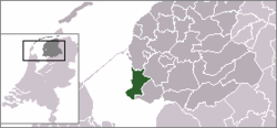
Coordinates: 52°59′N 5°26′E / 52.983°N 5.433°ECoordinates: 52°59′N 5°26′E / 52.983°N 5.433°E Country Netherlands Province Friesland Municipality Súdwest-Fryslân Area(2006) - Total 289.17 km2 (111.6 sq mi) - Land 96.68 km2 (37.3 sq mi) - Water 192.49 km2 (74.3 sq mi) Population (1 January, 2007) - Total 10,887 - Density 113/km2 (292.7/sq mi) Source: CBS, Statline. Time zone CET (UTC+1) - Summer (DST) CEST (UTC+2) Nijefurd (
 pronunciation (help·info)) is a former municipality in the northern Netherlands, in the province of Friesland.
It was formed in 1984 from the old municipalities of Hindeloopen, Stavoren, and Workum, and part of Hemelumer Oldeferd.
In 2011 it formed together with the municipalities of Bolsward, Sneek, Wûnseradiel and Wymbritseradiel the new municipality Súdwest Fryslân.
Population centres
Hemelum, Hindeloopen, It Heidenskip, Koudum, Molkwerum, Nijhuizum, Stavoren, Warns and Workum.
External links
Categories:- Former municipalities of Friesland
- Súdwest Fryslân
- Friesland geography stubs


Wikimedia Foundation. 2010.