- Interstate 410
-
This article is about the only Interstate currently numbered 410. For former routes numbered 410, see Interstate 410 (disambiguation).
Interstate 410
Connally Loop 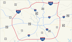
Route information Maintained by TxDOT Length: 49.49 mi[2] (79.65 km) Existed: 1959[1] – present Major junctions Beltway around San Antonio  I-10
I-10
 US 87
US 87
 US 90
US 90
 US 281
 I-35
I-35
 I-37
I-37Highway system Auxiliary route of the Interstate Highway System
Main • Auxiliary • BusinessHighways in Texas
Interstate • U.S. • TX (Loops – Spurs – Rec – FM)←  I-345
I-345I-610  →
→Interstate 410 (abbreviated I-410, and colloquially called Loop 410) is a loop route of Interstate 10 around San Antonio, Texas. It is identified as Connally Loop in honor of former Texas governor John Connally. The north and west section is undergoing a major expansion from six to ten lanes (five in each direction) from Culebra Road to the I-35 interchange as well as major interchanges being renovated at Bandera Road, I-10 and San Pedro Avenue, and an interchange recently constructed at US 281 near San Antonio International Airport.
Contents
History
As most cities in Texas San Antonio was served by a loop around the city long before the arrival of the Interstate Highway System. Loop 13, although not a freeway, served in this role up until the 1950s, when many of San Antonio's freeways were constructed. The northern half of Loop 13 followed the current path of I-410 while the southern half still exists on the south side of San Antonio. Much of the freeway was proposed during the mid-1950s with construction beginning on the northwest portion of the loop near I-10. In 1960 Loop 13 from I-10 to I-35 was redesignated as Loop 410 for continuity purposes. By 1961 the freeway had been completed from I-35 on the southwest side to just east of US 281 near the airport where it continued on to the east as a 4-lane highway to I-35. By 1964 the southern arc had been extended eastward from I-35 to Roosevelt Avenue and was under construction from Roosevelt to I-35 on the east side of the city. By 1967 the eastern arc had been completed to Interstate Highway standards and the remaining portion from US 281 to I-35 on the cities north side had been completely upgraded to Interstate Highway standards, but still carried the State Loop 410 designation until 1969 when it officially became Interstate 410.[1]
Due to the city growing primarily to the north, I-410 required upgrading along this stretch. It was expanded to six lanes in the late 1970s and early 1980s from Ingram Road to I-35 North. It was further expanded to six lanes from Ingram to Valley Hi Road in 1987. An additional westbound lane was added from I-10 West to Babcock Road in 1996.
Route description
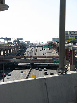 410 near the 410/281 Interchange in North Central San Antonio, TX.
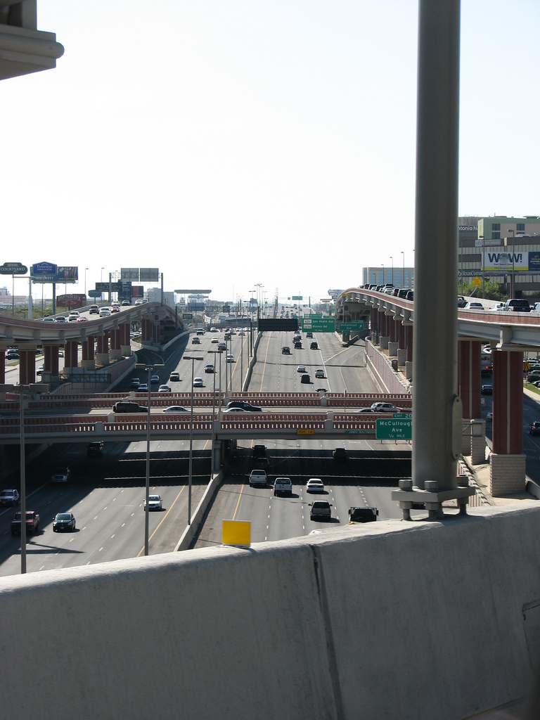
 I-410's interchange with I-37 on the southeast side of San Antonio, Texas.
Interstate 410 circumnavigates the city of San Antonio, officially beginning and ending at the junction with Interstate 35 on the southwest side of the loop. There are vast differences between the northern arc and southern arc of the loop. The northern arc serves the heavily urbanized portions of San Antonio and is currently being upgraded to as many as five lanes in each direction. The southern arc resembles more of a rural interstate as it transverses for the most part undeveloped portions of San Antonio as a two lane interstate. I-410 intersects I-10 twice, I-35 twice, I-37 once, as well as U.S. Highway 90, US 281, and State Highway 151, all freeways in the San Antonio metro area with the exception of 1604, which forms a secondary loop around the city. I-410 serves San Antonio International Airport, Lackland AFB, Fort Sam Houston, South Texas Medical Center, Southwest Research Institute, and Toyota Motor Manufacturing Texas.[3]
Future
410 is being widened along its entire northern arc from Culebra road to Austin Highway, with five lanes each way and intersection upgrades at I-10 and San Pedro, and an entire new interchange at US 281,[4][5] officially called the "San Antonio Web".[6]
Exit list
The entire route is in Bexar County, and forms a complete loop. Exit numbers correspond to mileage from the south junction with I-35.[3]
Location # Destinations Notes San Antonio 1 Frontage Road 2  FM 2536 (Old Pearsall Road)
3A Ray Ellison Drive Signed as exit 3 northbound 3B Medina Base Road Northbound exit is via exit 3 4 Valley Hi Drive – Lackland AFB 6 US 90 (Cleto Rodriguez Freeway) – San Antonio, Del Rio7 Marbach Road 8 Lakeside Parkway Southbound exit and entrance 9A  SH 151 (Stotzer Freeway) – SeaWorld
Signed as exit 9 northbound 9B W Military Drive Southbound exit and northbound entrance 10  FM 3487 (Culebra Road)
11 Ingram Road 12 Exchange Parkway Southbound exit and entrance 13A 
 SH 16 / Spur 421 (Bandera Road) – Leon Valley, San Antonio
North end of SH 16 concurrency 13B Evers Road Westbound exit and eastbound entrance 14A Summit Parkway Westbound exit and entrance 14B Callaghan Road Signed as exit 14 eastbound 14C Babcock Road Eastbound exit is via exit 14 15  Loop 345 (Fredericksburg Road) – Balcones Heights
16 I-10 / US 87 (McDermott Freeway) – San Antonio, El Paso17 Vance Jackson Road, Cherry Ridge Drive Signed as exit 17B eastbound Castle Hills 18 Jackson-Keller Road, West Avenue 19A Honeysuckle Lane Eastbound exit is via exit 18 19B  FM 1535 (Military Highway) – Castle Hills
Signed as exit 19 eastbound 19  FM 2696 (Blanco Road)
Westbound exit is via exit 20A San Antonio 20A  Spur 537 north (San Pedro Avenue)
Signed as exit 20 eastbound 20B McCullough Avenue Eastbound exit is via exit 20 21A US 281 (McAlister Freeeway) – Johnson City, Downtown"San Antonio Web", fully opened June 9, 2008[5] 21 Airport Boulevard, Wetmore Road – Int'l Airport Signed as exit 21B eastbound 22 Broadway 23 Nacogdoches Road 24 Harry Wurzbach Road – Fort Sam Houston 25A Starcrest Drive 25B  FM 2252 (Perrin-Beitel Road)
26A  Loop 368 south – Alamo Heights
Signed as exit 26 westbound 26B Interchange Parkway, Perrin Creek Drive Eastbound exit and westbound entrance I-35 north (Pan Am Expressway) – AustinNorth end of I-35 concurrency Randolph Boulevard – Windcrest 165  FM 1976 (Walzem Road)
164B Eisenhauer Road 164A Rittiman Road South end of I-35 concurrency I-35 south (Pan Am Expressway) – DowntownSouthbound exit and northbound entrance 30 Space Center Drive Northbound exit and entrance 30 Binz-Engleman Road Southbound exit and northbound entrance 31A  FM 78 – Kirby
Signed as exit 32 northbound 31 I-35 south (Pan Am Expressway) / Binz-Engleman Road – San AntonioNorthbound left exit and southbound entrance 31B  Loop 13 (W.W. White Road)
No northbound exit 32 Dietrich Road Southbound exit only 33 I-10 (Lopez Freeway) / US 90 – San Antonio, Houston34  FM 1346 (East Houston Street)
35 US 87 (Rigsby Avenue) – Victoria, La Vernia37 Southcross Boulevard/New Sulpher Springs Road, Sinclair Road 39  Spur 117 (W.W. White Road)
41 I-37 / US 281 north (Adams Freeway) – San Antonio, Corpus ChristiEast end of US 281 concurrency 42  Spur 122 (South Presa Street) / Southton Road
43 Espada Road – San Antonio Missions National Historical Park Westbound exit is via exit 44 44  US 281 south / Spur 536 (Roosevelt Avenue) – Pleasanton
West end of US 281 concurrency 46 Moursund Boulevard 48 Zarzamora Street 49  SH 16 south (Palo Alto Road) / Spur 422 (Poteet-Jourdanton Freeway) – Poteet
East end of SH 16 concurrency 51  FM 2790 (Somerset Road)
53 I-35 (Pan Am Expressway) – San Antonio, LaredoReferences
- ^ a b Texas Department of Transportation. "Highway Designation File - Interstate Highway No. 410". http://www.dot.state.tx.us/tpp/hwy/IH/IH0410.htm. Retrieved 2008-02-26.
- ^ Federal Highway Administration. "Route Log - Auxiliary Routes of the Eisenhower National System of Interstate and Defense Highways - Table 2". http://www.fhwa.dot.gov/reports/routefinder/table2.htm. Retrieved 2008-02-26.
- ^ a b Google, Inc. Google Maps – overview map of I-410 (Map). Cartography by Google, Inc. http://maps.google.com/maps?f=d&hl=en&geocode=2355175623909919017,29.316846,-98.608354%3B6009444865328575504,29.316841,-98.608338&saddr=I-410+W+%4029.316846,+-98.608354&daddr=29.5185,-98.414154+to:I-410+W+%4029.316841,+-98.608338&mra=dpe&mrcr=0&mrsp=1&sz=10&via=1&sll=29.386962,-98.981323&sspn=0.686836,1.505127&ie=UTF8&ll=29.419862,-98.497925&spn=0.343308,0.752563&z=11. Retrieved 2008-02-24.
- ^ Driscoll, Patrick (2007-06-19). "Decades in waiting, ramp open". San Antonio Express-News. http://www.mysanantonio.com/news/metro/stories/MYSA061907.01B.ramp.345cbee.html. Retrieved 2008-02-26.
- ^ a b Driscoll, Patrick (2008-06-10). "U.S. 281/Loop 410 interchange ramps are complete". San Antonio Express-News. http://www.mysanantonio.com/news/metro/stories/MYSA061008.1A.Lastramps.389a3a1.html. Retrieved 2008-06-20.
- ^ Driscoll, Patrick (2006-01-16). "Now there's a name for it". San Antonio Express-News. Archived from the original on 2008-02-23. http://web.archive.org/web/20080223203630/http://blogs.mysanantonio.com/weblogs/traffic/archives/2006/01/missing_interch.html. Retrieved 2008-06-20.
Auxiliary routes of Interstate 10 California: 110 • 110 (former) • 210 • 710 — Arizona: 410 (unbuilt) • 510 (former) • 710 (unbuilt) — Texas: 110 • 410 • 610 — Louisiana: 110 • 210 • 310 • 310 (unbuilt) • 410 (unbuilt) • 410 (unbuilt) • 510 • 610 • 910 (unsigned) — Mississippi: 110 • 310 (proposed) — Alabama: 210 (former) — Florida: 110
San Antonio area freeways Radial Pan Am Expressway (I-35) • Rodriguez Freeway (US 90) • Stotzer Freeway (SH 151) • McDermott Freeway/Jose Lopez Freeway (I-10) • McAllister Freeway/San Pedro Avenue (US 281) • Adams Freeway/Bordelon Freeway (I-37) • Poteet-Jourdanton Freeway (Spur 422)Belt Connally Loop (I-410) • Wurzbach Parkway • Anderson Loop (Loop 1604)Other limited-access roads General Hudnell Drive (Spur 371) • Kelly Parkway (proposed)Interstate Highways in Texas Signed Unsigned Bexar County highways Interstate Highways U.S. Highways State Highways State Loops and Spurs Farm and Ranch to Market Roads FM 78 • FM 147 • FM 471 • FM 476 • FM 1303 • FM 1346 • FM 1516 • FM 1517 • FM 1518 • FM 1560 • FM 1628 • FM 1863 • FM 1937 • FM 1957 • FM 2536 • FM 2537 • FM 2538 • FM 2696 • FM 2790 • FM 3351 • FM 3432 • FM 3465 • FM 3499
Categories:- Three-digit Interstate Highways
- Interstate Highways in Texas
- Transportation in San Antonio, Texas
- Orbital roads in the United States
- Interstate 10


Wikimedia Foundation. 2010.