- Nagano Expressway
-
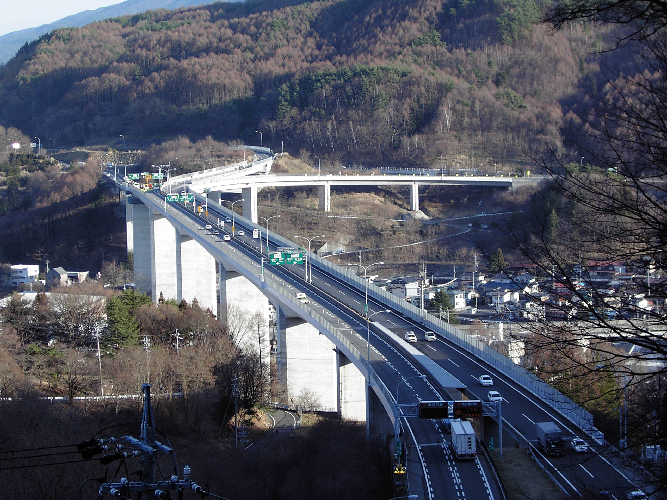
Nagano Expressway
長野自動車道 Route information Maintained by East Nippon Expressway Company and Central Nippon Expressway Company Length: 75.8 km[2] (47.1 mi) Existed: 1986[1] – present Major junctions From: Okaya Junction in Okaya, Nagano
 Chūō Expressway
To: Kōshoku Junction in Chikuma, Nagano
Jōshin-etsu ExpresswayLocation Major cities: Shiojiri, Matsumoto, Azumino Highway system The Nagano Expressway (長野自動車道 Nagano Jidōsha-dō) is a 4-laned national expressway in Nagano Prefecture, Japan. It is owned and operated by East Nippon Expressway Company and Central Nippon Expressway Company.
Contents
Naming
The expressway is officially referred to as the Chūō Expressway Nagano Route. The Chūō Expressway Nagano Route is the official designation for the Chūō Expressway between Takaido Interchange and Okaya Junction (concurrent with the Chūō Expressway Nishinomiya Route), the Nagano Expressway between Okaya Junction and Kōshoku Junction, and the Jōshin-etsu Expressway between Kōshoku Junction and Suzaka-Naganohigashi Interchange (concurrent with the Kan-Etsu Expressway Jōetsu Route).[3]
Overview
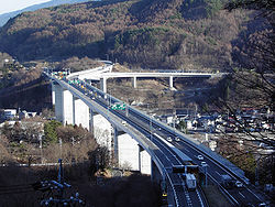 Nagano Expressway
The expressway was originally built and managed by Japan Highway Public Corporation. On October 1, 2005, the management of the route was assigned to East Nippon Expressway Company (Kōshoku Junction to Toyoshina Interchange, excluding the interchange) and Central Nippon Expressway Company (Okaya Junction to Toyoshina Interchange, including the interchange).[4][5]
The route of the expressway runs through the central part of Nagano Prefecture. From the origin at a junction with the Chūō Expressway in the city of Okaya near Lake Suwa, the expressway follows a northerly course to Matsumoto, the major city in the central Nagano area. From here the expressway follows a winding northeasterly course through mountainous areas before reaching the terminus in the city of Chikuma. Beyond the terminus, the roadway continues as the Jōshin-etsu Expressway towards the city of Nagano, the prefectural capital.
History
- March 25, 1986 - Okaya Junction - Okaya Interchange section is opened as part of the Chūō Expressway.
- March 5, 1988 - Okaya Interchange - Matsumoto Interchange section is opened, Okaya Junction - Okaya Interchange section is incorporated as part of the Nagano Expressway.
- August 3, 1988 - Matsumoto Interchange - Toyoshina Interchange section is opened.
- March 25, 1993 - Toyoshina Interchange - Kōshoku Junction section is opened, connects with Jōshin-etsu Expressway.
- October 1, 2006 - Obasute Smart Interchange is opened at Obasute Service Area.
List of interchanges and features
- IC - interchange, SIC - smart interchange, JCT - junction, SA - service area, PA - parking area, BS - bus stop, CB - snow chains, TN - tunnel, BR - bridge
No. Name Connections Dist. from
OriginDist. from
TerminusBus Stop Notes Speed Limit Location
(all in Nagano)(21) Okaya JCT Chūō Expressway0.0 75.8 70km/h Okaya BR Okaya Overpass ↓ ↑ Length - 1,488m TN Okaya Tunnel ↓ ↑ 1 National Route 20 3.7 72.1 ○ TN Enrei Tunnel ↓ ↑ Shiojiri PA Midoriko PA 8.4 67.4 ○ 2 Shiojiri IC  National Route 20 (Shiojiri Bypass)
10.9 64.9 100km/h BS Hirooka-Nomura BS 14.1 61.7 ○ 3 Shiojiri-kita IC Pref. Route 27 (Matsumoto Airport Shiojiri-kita Inter Route) 17.6 58.2 BR Naraigawa Bridge ↓ ↑ Matsumoto BS Kanbayashi BS 21.0 54.8 ○ <3-1> Matsumoto JCT  Chūbu-Jūkan Expressway
↓ ↑ Planned 4 Matsumoto IC National Route 15825.8 50.0 ○ SA Azusagawa SA 29.1 (46.7) Kōshoku-bound only BR Azusagawa Bridge ↓ ↑ Length - 390m Azumino SA Azusagawa SA (29.9) 45.9 Okaya-bound only 5 Toyoshina IC Pref. Route 57 (Toyoshina Inter Horigane Route)
Pref. Route 310 (Hakuyachō Tazawa Teishajō Route)33.1 42.7 ○ 80km/h BR Saigawa Bridge ↓ ↑ Length - 650m BS Akashina BS 36.5 39.3 ○ TN Akashina Tunnel ↓ ↑ BS Shiga BS 40.5 35.3 ○ Emergency vehicle entrance/exit planned Matsumoto TN Tachitoge Tunnel ↓ ↑ Chikuhoku BS Honjō BS 47.3 28.5 ○ Emergency vehicle entrance/exit BS Sakakita BS 51.5 24.3 ○ PA Chikuhoku PA 52.8 23.0 Omi 6 Omi IC  National Route 403
56.3 19.5 ○ TN Ipponmatsu Tunnel ↓ ↑ Chikuma SA Chikumagawa Bridge ↓ ↑ Length - 530m Nagano Chikuma 7 Kōshoku IC  National Route 18
74.9 0.9 ○ (12) Kōshoku JCT Jōshin-etsu Expressway75.8 0.0 Through to Jōshin-etsu ExpresswayThere is one snow chain changing area between Obasute Service Area and Kōshoku Interchange.
References
- ^ "Expressway Opening Dates" (in Japanese). http://www2.tokai.or.jp/stt/road/expwyopn.html. Retrieved 2008-04-16.
- ^ Ministry of Land, Infrastructure and Transport, Kanto Regional Development Bureau. "Road Timetable" (in Japanese). http://www.ktr.mlit.go.jp/kyoku/road/jikoku/station/nagano.html. Retrieved 2008-04-16.
- ^ Ministry of Land, Infrastructure and Transport. "High Standard Trunk Road Map" (in Japanese) (pdf). http://www.mlit.go.jp/road/ir/ir-yosan/h20/s07.pdf. Retrieved 2008-04-13.
- ^ Mizutani, Fumitoshi; Uranishi, Shuji (2006). "Privatization of the Japan Highway Public Corporation: Policy Assessment" (pdf). 46th Congress for the European Regional Science Association. Volos, Greece. http://www-sre.wu-wien.ac.at/ersa/ersaconfs/ersa06/papers/226.pdf. Retrieved 2008-04-11.
- ^ "NEXCO-Central Business Outline" (pdf). http://www.c-nexco.co.jp/english/pdf/nexco_english.pdf. Retrieved 2008-04-13.
External links
East Nippon Expressway Company National Expressways Akita • Aomori • Ban-etsu • Dōtō • Hachinohe • Higashi-Kantō • Hokkaidō • Hokuriku • Jōban • Jōshin-etsu • Kamaishi • Kan-Etsu • Kita-Kantō • Nagano • Nihonkai-Tōhoku • Sasson • Shin-Kūkō • Tateyama • Tōhoku • Tōhoku-Chūō • Tokyo Gaikan • YamagataToll Roads Chiba-Tōgane Road • Daisan Keihin Road • Fukagawa-Rumoi Expressway • Futtsu Tateyama Road • Hidaka Expressway • Higashi-Mito Road • Keiyō Road • Ken-Ō Expressway • Momoishi Road • Sanriku Expressway • Sendai-Hokubu Road • Sendai-Tōbu Road • Tokyo Bay Aqua-Line • Yokohama Shindō • Yokohama Yokosuka Road • Yonezawa Nan-yo Road • Yuzawa-Yokote RoadCentral Nippon Expressway Company National Expressways Chūbu-Ōdan • Chūō • Higashi-Meihan • Hokuriku • Ise • Isewangan • Kisei • Meishin • Nagano • Shin-Meishin • Tōkai-Hokuriku • Tōmei • Shin TōmeiToll Roads Chūbu-Jūkan Expressway • Hachiōji Bypass • Hakone Shindō • Higashifuji-goko Road • Ken-Ō Expressway • Nishi-Fuji Road • Odawara-Atsugi Road • Seishō Bypass • Shinshōnan Bypass • Tōkai-Kanjō Expressway Expressways of Japan
East Nippon Expressway Company Akita • Aomori • Ban-etsu • Dōtō • Hachinohe • Higashi-Kantō • Hokkaidō • Hokuriku • Jōban • Jōshin-etsu • Kamaishi • Kan-Etsu • Ken-Ō • Kita-Kantō • Nagano • Nihonkai-Tōhoku • Sasson • Shin-Kūkō • Tateyama • Tōhoku • Tōhoku-Chūō • Tokyo Gaikan • YamagataCentral Nippon Expressway Company Chūbu-Ōdan • Chūō • Higashi-Meihan • Hokuriku • Ise • Isewangan • Ken-Ō • Kisei • Meishin • Nagano • Shin-Meishin • Tōkai-Hokuriku • TōmeiWest Nippon Expressway Company Honshū-Shikoku Bridge Expressway Company Kobe-Awaji-Naruto • Nishiseto • Seto-ChūōUrban Expressways Categories:- Expressways in Japan

Wikimedia Foundation. 2010.