Bou Regreg

Bou Regreg
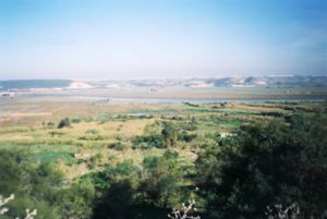
Valley of the Bou Regreg near Rabat, Morocco

The Bou Regreg (Arabic: أبو رقراق‎) is a river located in western Morocco which discharges to the Atlantic Ocean between the cities of Rabat and Salé. The estuary of this river is termed Wadi Sala.[1]

The river is 240 kilometres long, with a tidal estuary of approximately 24 kilometres extending upriver. Its average discharge is 23 m3/s and can reach 1500 m3/s during periods of flooding. The source of the river originates from the Middle Atlas mountains at an altitude of 1627 meters on the level of Jbel Mtourzgane (Province of Khemisset) and of Grou (Province of Khénifra) and descends to its mouth at the Atlantic Ocean separating the cities of Rabat to the south and Salé to the north.

Contents

Water quality

Water quality issues of the Bou Regreg include tidal saltwater intrusion, excessive runoff of nitrates from agricultural land uses and mercury contamination thought to arise from use of certain pesticides within the drainage basin.[2]

History

The Phoenicians and the Carthaginians, who founded several colonies in Morocco, inhabited the banks of the Bou Regreg approximately two kilometers from its mouth at the ancient site of Chellah. This archaeological site contains the ruins of a Roman town known as Sala Colonia and referred to as Sala by Ptolemy. Chellah was a significant ancient port city town with remains including the Decumanus Maximus, or principal way, as well as those of a forum, a monumental fountain, a triumphal arch, and other Roman ruins.[3]

See also

Citations

  1. ^ Voyages and travels, Hakluyt Society, page 280 (1962)
  2. ^ Tarik Bahaj, Geochemical Characteristics of the Continental Waters Downstream from the Bou Regreg Basin and the Temara Plain, Morocco, October 30, 2007
  3. ^ C. Michael Hogan, Chellah, The Megalithic Portal, ed. A. Burnham, 2007[1]

Coordinates: 34°01′55″N 6°49′51″W / 34.0319°N 6.83083°W / 34.0319; -6.83083


Wikimedia Foundation. 2010.

Игры ⚽ Поможем сделать НИР

Look at other dictionaries:

  • Bou-Regreg — Tal des Bou Regreg im Hinterland von Rabat und SaléVorlage:Infobox Fluss/KARTE fehlt …   Deutsch Wikipedia

  • Bou Regreg — Bou Regrẹg   [bu ], französisch Oued Bou Regreg [wɛd ], Fluss in Marokko, etwa 180 km lang, entspringt auf der Westabdachung des Mittleren Atlas und mündet zwischen Rabat und Salé in den Atlantik; Stauwerk …   Universal-Lexikon

  • Bou RegReg — Bouregreg Bouregreg Caractéristiques Longueur 240 km Bassin 10 000 km2 …   Wikipédia en Français

  • Bou Regreg — Bouregreg Bouregreg Caractéristiques Longueur 240 km Bassin 10 000 km2 …   Wikipédia en Français

  • Republic of Bou Regreg — The Republic of Bou Regreg was a 17th century governmental unit [Citation last = Stewart first = John author link = date = 2006 title = African States and Rulers edition = 3rd publication place = Jefferson NC, USA place = publisher = McFarland Co …   Wikipedia

  • Rabat — Rabat …   Deutsch Wikipedia

  • Salé — Jachthafen im Südosten der Altstadt. Blick von Rabat nach Norden. An der Stelle des Jachthafens führte bis ins 18. Jahrhundert ein Kanal zu einem kleinen Hafen innerhalb der Stadtmauer Salé (arabisch ‏سلا‎, DMG Salā) ist die Nachba …   Deutsch Wikipedia

  • Maroc — 34° 02′ 00″ N …   Wikipédia en Français

  • Islamische Republik Marokko — Ansätze, republikanische Staatswesen in Marokko zu errichten, gab es in der Geschichte des maghrebinischen Königreichs mehrfach, eine republikanische Opposition operiert bis heute von Schweden aus. Inhaltsverzeichnis 1 Republik Bou Regreg 2 Rif… …   Deutsch Wikipedia

  • Marokkanische Republik — Ansätze, republikanische Staatswesen in Marokko zu errichten, gab es in der Geschichte des maghrebinischen Königreichs mehrfach, eine republikanische Opposition operiert bis heute von Schweden aus. Inhaltsverzeichnis 1 Republik Bou Regreg 2 Rif… …   Deutsch Wikipedia

Share the article and excerpts

Direct link
Do a right-click on the link above
and select “Copy Link”