- Arizona State Route 101
Infobox road
state=AZ
type=SR
route=101
alternate_name=Agua Fria Freeway, Pima Freeway, Price Freeway
maint=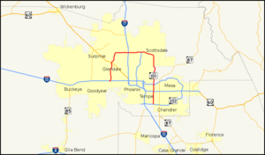
length_mi=60.98
length_round=2
length_ref=cite web |url=http://tpd.az.gov/data/reports/2006SHSLog.pdf |title=2006 ADOT Highway Log|author=Arizona Department of Transportation |accessdate=2008-04-09]
established=
direction_a=CCW
starting_terminus=jct|state=AZ|I|10 in Tolleson
junction=jct|state=AZ|I|17 in Phoenix
jct|state=AZ|US|60 in Tempe|direction_b=CW
ending_terminus=jct|state=AZ|SR|202 in Chandler
previous_type=SR
previous_route=99
next_type=SR
next_route=143State Route 101, or Loop 101, (spoken as one-oh-one) is a semi-
beltway encompassing much of thePhoenix Metropolitan Area in theUnited States . It connects several large suburbs of Phoenix, including Tolleson, Glendale, Peoria, North Phoenix, Scottsdale, Mesa, Tempe, and Chandler. Construction began in the late-1980s and was completed in 2001.Additional general purpose lanes and ahigh occupancy vehicle lane (HOV) are being constructed along the eastern stretch of Loop 101 from Scottsdale to Chandler, starting at Princess Drive to Loop 202, Santan Freeway.Loop 101 has interchanges with almost all area freeways, including: Loop 202, US 60, SR 51,
Interstate 17 , and Interstate 10 along its 61-mile (98 km) route.Route description
mall.
Loop 101 is now heading eastward on the Beardsley Road alignment. The freeway enters North Phoenix, and at
milepost 23, Loop 101 intersectsInterstate 17 near theDeer Valley Airport , convert|15|mi|km north ofDowntown Phoenix . Continuing east, it passes through the Union Hills area and then has an interchange with the northern terminus of SR 51 (Piestewa Freeway) at milepost 30. East of its junction with SR 51, Loop 101 curves south through Scottsdale in the northeast valley on the Pima Road alignment. The freeway provides access to Downtown Scottsdale, The Scottsdale Pavilions,Scottsdale Community College , andScottsdale Fashion Square .Continuing south, Loop 101 encounters an interchange with the Red Mountain Freeway portion of Loop 202 in Tempe at milepost 51, near the campus of
Arizona State University . This interchange is partially built over the Salt River. After this interchange, the freeway interchanges with US 60 at milepost 55 before entering Chandler. Loop 101 provides access toChandler Fashion Center just prior to concluding at milepost 61 at an interchange with the Santan Freeway portion of Loop 202. [http://maps.google.com/maps?f=d&saddr=33.29366,-111.89352&daddr=AZ-101+W+to:AZ-101+W+to:Unknown+road&hl=en&geocode=%3BFY6HAQId2GtU-Q%3BFc66AQIdys5P-Q%3BFXWd_gEd7OlO-Q&mra=dme&mrcr=0&mrsp=0&sz=13&via=1,2&sll=33.306716,-111.91309&sspn=0.072163,0.153809&ie=UTF8&ll=33.458943,-111.968536&spn=0.576287,1.230469&z=10]Photo enforcement
In 2006, Scottsdale installed speed enforcement cameras along its stretch of Loop 101 to combat the high
fatality rate along its section offreeway . However, the speed enforcement cameras were discontinued in August 2006. They were restarted again in late February 2007.The photo enforcement was based on inductive sheeting on the
freeway bed located at six fixed positions along the freeway - three in each direction. The photo enforcement was in a trial phase, with the trial ending in December 2006. In January 2007, the program was authorized by Arizona GovernorJanet Napolitano to resume in February 2007.cite web|last=Ferraresi|first=Michael|title=Signs warn motorists of speed cameras' return|publisher=The Arizona Republic|date=2007-02-09|url=http://www.azcentral.com/community/scottsdale/articles/0209sr-cameras09-ON.html|accessdate=2007-02-10]There has been much criticism of the program since its inception. For instance, in May 2006, a vehicle was allegedly clocked traveling at 147 MPH (237 km/h) on Loop 101. Scottsdale police arrested Lawrence Pargo soon afterwards. According to the manufacturer
Hyundai , cite web|title=Hyundai Sonata LX|publisher=Car and Driver|url=http://www.caranddriver.com/roadtests/9741/hyundai-sonata-lx-page4.html] the vehicle the suspect was driving had acentrifugal governor , and was only capable of traveling 137 MPH (220 km/h).cite web|title=Accused 147 mph speeder gets day in court|publisher=East Valley Tribune|url=http://www.eastvalleytribune.com/index.php?sty=69787]The system is calibrated to ticket anyone traveling 76 MPH (122 km/h) or greater, as 65 MPH (105 km/h) is the predetermined
speed limit . The system is also designed for night time use and utilizes equipment with a high intensity flash and full motionvideo capture to take pictures of fast-moving objects.cite web|title=Photo Enforcement 101|publisher=City of Scottsdale|url=http://www.scottsdaleaz.gov/photoradar/101faq.asp]Where does the money collected from fines go?
For a typical $162 ticket:
$78 (about) - Goes to state surcharges for Criminal Justice Enhancement Fund and other designated state programs.
$42 - Goes to Redflex Traffic Systems, the city's photo enforcement contractor.
$32 - Goes to covering general operating costs for the program, including city rental payments to
Redflex for the equipment and other police, prosecutor andcourt costs .$10 - Goes for a fund used only for court operations enhancements. [http://www.scottsdaleaz.gov/photoradar/101faq.asp]
Current construction projects
An exit in Northeast Phoenix at 64th Street is currently under
construction and due for completion sometime in 2008. [ [http://www.azdot.gov/Highways/Valley_Freeways/Loop_101/Pima/index.asp] ]Crews are currently working to complete
HOV lanes between Princess Drive in Scottsdale and Loop 202 (Santan Freeway) in Chandler. The first segment of HOV lanes, between Loop 202 (Red Mountain Freeway) and Via de Ventura Drive, is expected to be opened to traffic in November 2008.Nicknames
Sections of Loop 101 are given nicknames:
*Agua Fria Freeway in the west valley from I-10 to I-17.
*Pima Freeway in the east valley from I-17 to Loop 202's Red Mountain Freeway.
*Price Freeway from Loop 202's Red Mountain Freeway to Loop 202's Santan Freeway.Exit list
The entire route is in Maricopa County.
References
ee also
*Loop 202
*Loop 303
*Metropolitan Phoenix Freeways External links
* [http://www.dot.state.az.us/Highways/RFS/aguafria/afschedule.asp Agua Fria Loop 101 construction history]
* [http://www.dot.state.az.us/Highways/RFS/pima/pimaschedule.asp Pima Loop 101 construction history]
* [http://www.dot.state.az.us/Highways/RFS/price/prschedule.asp Price Loop 101 construction history]
* [http://www.azdot.gov/Highways/Valley_Freeways/Loop_101/Pima/index.asp Loop 101 Current Projects & Construction - AZ DOT]

Wikimedia Foundation. 2010.