- Leslie Street Spit
-
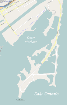 Map of Leslie Street Spit
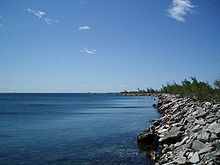 View along Leslie Street Spit
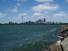 Toronto skyline from the Spit
The Leslie Street Spit, or officially the Outer Harbour East Headland, is a man-made headland in Toronto, Ontario, extending from the city's east end in a roughly southwesterly direction into Lake Ontario. It is about 5 km long.
Its common name is technically incorrect, since it is not truly a spit, but Torontonians almost never use the official name. The road running along the peninsula is a southern extension of Leslie Street, hence the popular nickname.
Contents
Construction and evolution
The former Toronto Harbour Commission (THC)(known as the Toronto Port Authority since 1999) began construction of the peninsula in the late 1950s. Its originally foreseen purpose was to provide a breakwater for Toronto's Outer Harbour, which itself was expected to be necessary to handle the increase in shipping on the Great Lakes after the Saint Lawrence Seaway opened in 1959. However, owing to the containerization revolution of the 1960s, the need for an outer harbour never arose, and all cargo ships calling at Toronto still use the Inner Harbour, while the Outer Harbour sees only pleasure boat traffic.
The need for the headland, however, did not disappear. In the 1960s and 1970s, development in Toronto proceeded rapidly, and the Leslie Street Spit was a convenient place to dump the endless supply of rubble and earth generated by all the building projects in the city. Originally a long, slender finger of bare land stretching out into the lake, the headland eventually developed several lobes enclosing small bays, and was eventually colonized by a variety of plant life. [1] Cottonwood and poplar forests now cover much of the headland, and it has become a fine example of the development of pioneer plant communities and ecological succession. About 400 species of plants have been identified on the Leslie Street Spit.
The inner part of the spit consists of three embayments. These were designed to hold dredged material from the Inner Harbour and the Keating Channel. The first embayment has now been filled. It has been capped with clean fill and is being restored by the Toronto and Region Conservation Authority as a marsh. The remaining two embayments have about 50 years' capacity remaining.
The Leslie Street Spit's evolution into an urban wilderness was never in the city's plans. Indeed, the spit's status as such was secured by a number of organizations, with the citizens' advocacy group known as Friends of the Spit at the forefront of advocacy to retain the spit in as natural a state as possible.
Several development plans have been put forward. One development plan involved an "aquatic park" which would have included a hotel, an amphitheatre, government docks, private yacht clubs, parking for 2,000 cars, a waterskiing school, and camping, among other facilities. In 1968, the Toronto Harbour Commission envisaged building yet another "spit" further west, and creating a huge residential area, complete with a new airport. These plans were debated at length, but as they were, the previously lifeless Leslie Street Spit was coming to life, and many Torontonians decided that they liked the idea of having a wilderness right in the city.
Currently, the northern half of the spit has been designated as Tommy Thompson Park, named after a former Toronto Parks Commissioner, and managed by the Toronto and Region Conservation Authority. The southern half is still an active dumping zone, managed by the Toronto Port Authority. Eventually the entire spit will become parkland.
Friends of the Spit was founded in 1977. Its original members included people as varied as birdwatchers, naturalists, and cyclists. The Friends' goals, quite simply, are to keep the Leslie Street Spit open to the public (The THC had not allowed public access until 1973; the Spit is now open to the public from 9:00 am. to 6:00 p.m. on weekends and statutory holidays in the summer, and from 9:00 a.m. to 4:30 p.m. on weekends and statutory holidays in the winter. It is closed weekdays owing to the ongoing construction of the spit, conducted by the Toronto Port Authority), and to keep it in its natural — or, perhaps more accurately, naturalized state. Thus far, all development plans have come to naught, and the spit is still open to the public.
The Leslie Street Spit is a car-free area when the park is open, with strictly controlled vehicle access to the mooring area when the park is closed. The spit's outermost end is known as Vicki Keith Point, after a famous Canadian swimmer. There has been an automated lighthouse there since 1974.
Shuttle service
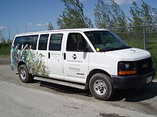 Shuttle van
The park provides free shuttle service from May to Thanksgiving weekend (October) from 9am to 5:30pm. The shuttle van stops at the front entrance, at the Aquatic Park Sailing Club (APSC), and at the footbridge. Riders can get on or off anywhere along the bus route. [2]
The Aquatic Park Sailing Club (a 100-mooring sailing club founded in 1976) pays for, in part, the van and the habitat creation on the Spit.
Important Bird Area
Quite a number of bird species are also to be found on the Leslie Street Spit. More than 300 species of birds are to be found, 45 of which actually breed on the headland.[3] Among the birds that may be observed on the headland are the ring-billed gull, the black-crowned night-heron, the double-crested cormorant, the common tern, the Caspian tern, and the herring gull. [4]
Owing to the Leslie Street Spit's importance to so many bird species, it has been designated an Important Bird Area (IBA) by Nature Canada and Bird Studies Canada which are the Canadian partners of BirdLife International. Peninsula D has also become the site of a comprehensive bird research station, run by the TRCA. The Tommy Thompson Park Bird Research Station operates 7 days a week during spring and fall migration, and runs other projects within the Greater Toronto Area throughout the rest of the year. Visitors to the station are welcome on weekends when the park is open.
See also
- Toronto waterfront
- Toronto Port Authority
- Toronto Islands
- Leslie Spit Treeo - Local band named after the area
- Toronto Harbour Light
References
- ^ Ashbridge's Bay - An Anthology of Writings by Those Who Knew and Loved Ashbridge's Bay. Toronto Ornithological Club, Toronto, Canada. 1998. p. 105. ISBN 0-9695562-1-7.
- ^ "Where do I pick up the Shuttle Van?". Toronto and Region Conservation Authority. http://www.tommythompsonpark.ca/home/faq.dot#q7.
- ^ W.G. Wilson, E.D. Cheskey. Leslie Street Spit, Tommy Thompson Park: Important Bird Area Conservation Plan. IBA Steering Committee. July 2001. [1]
- ^ Birds of Toronto - A Guide to Their Remarkable World. City of Toronto Biodiversity Series. 2009. p. 23.
External links
- Tommy Thompson Park (Official homepage)
- Friends of the Spit site
- Tommy Thompson Park Bird Research Station
- Toronto Star article about the Leslie Street Spit
- Important Bird Areas of Canada site
Coordinates: 43°37′4″N 79°20′33″W / 43.61778°N 79.3425°W
Categories:- Geography of Toronto
- Important Bird Areas of Canada
- Spits of Canada


Wikimedia Foundation. 2010.