- 14th Street–Union Square (New York City Subway)
Infobox NYCS
name = 14th Street–Union Square
bg_color = black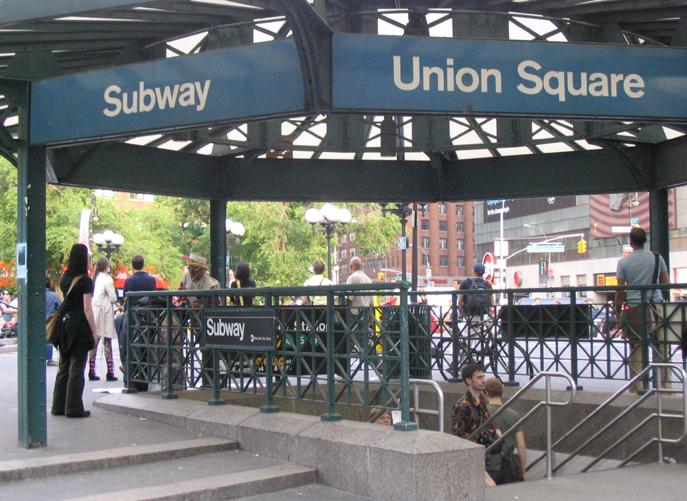
passengers = 31.621 million
pass_year=2006
pass_percent=5
service=Union Square
borough = Manhattan14th Street–Union Square is a
New York City Subway station complex shared by theIRT Lexington Avenue Line , theBMT Broadway Line , and theBMT Canarsie Line . It is located at the intersection of Fourth Avenue and 14th Street, underneath Union Square inManhattan , and is served by:*, NYCS|6, NYCS|L, NYCS|N, and NYCS|Q trains at all times
* and NYCS|R trains at all times except late nights
* trains weekdaysThe station is an important interconnection point, as it is the only station where Canarsie Line riders can transfer to the heavily-used Lexington Avenue Line, and it is also the only station where Broadway Line riders coming in from Brooklyn can transfer to uptown express trains to business locations in east Midtown.
The station is also located on the border of several neighborhoods with popular business, residential and nightlife destination spots, including the East Village to the southeast,
Greenwich Village to the south and southwest, Chelsea to the northwest, and both the Flatiron District and Gramercy to the north and northeast.There are three originally separate stations here, which were combined sometime after unification of the subways in 1940. They now share a mezzanine, common entrance points, and unified signage. 14th Street Union Square station was placed on the
National Register of Historic Places in 2005. [ [http://www.nationalregisterofhistoricplaces.com/NY/New+York/state.html New York County Listings at the National Register of Historic Places (Structure #05000671)] ] __TOC__IRT Lexington Avenue Line platforms
Infobox NYCS
bg_color = #007527
line = IRT Lexington Avenue Line
service = Lexington
platforms = 2island platform s, 2 closedside platform s (partially visible)
tracks = 4
open_date=October 27 ,1904 New York Times , [http://www.nycsubway.org/articles/nytimes-1904-dayoneopen.html Our Subway Open: 150,000 Try It] ,October 28 ,1904 ]
north_line = IRT Lexington Avenue Line
north_local_station = 23rd Street
north_local_service = Lexington local
north_express_station = Grand Central–42nd Street
north_express_service = Lexington express
north_express_station_acc = yes
north_custom_station = Closed:
18th Street
south_line = IRT Lexington Avenue Line
south_local_station = Astor Place
south_local_service = Lexington local
south_express_station = Brooklyn Bridge–City Hall
south_express_station_acc = yes
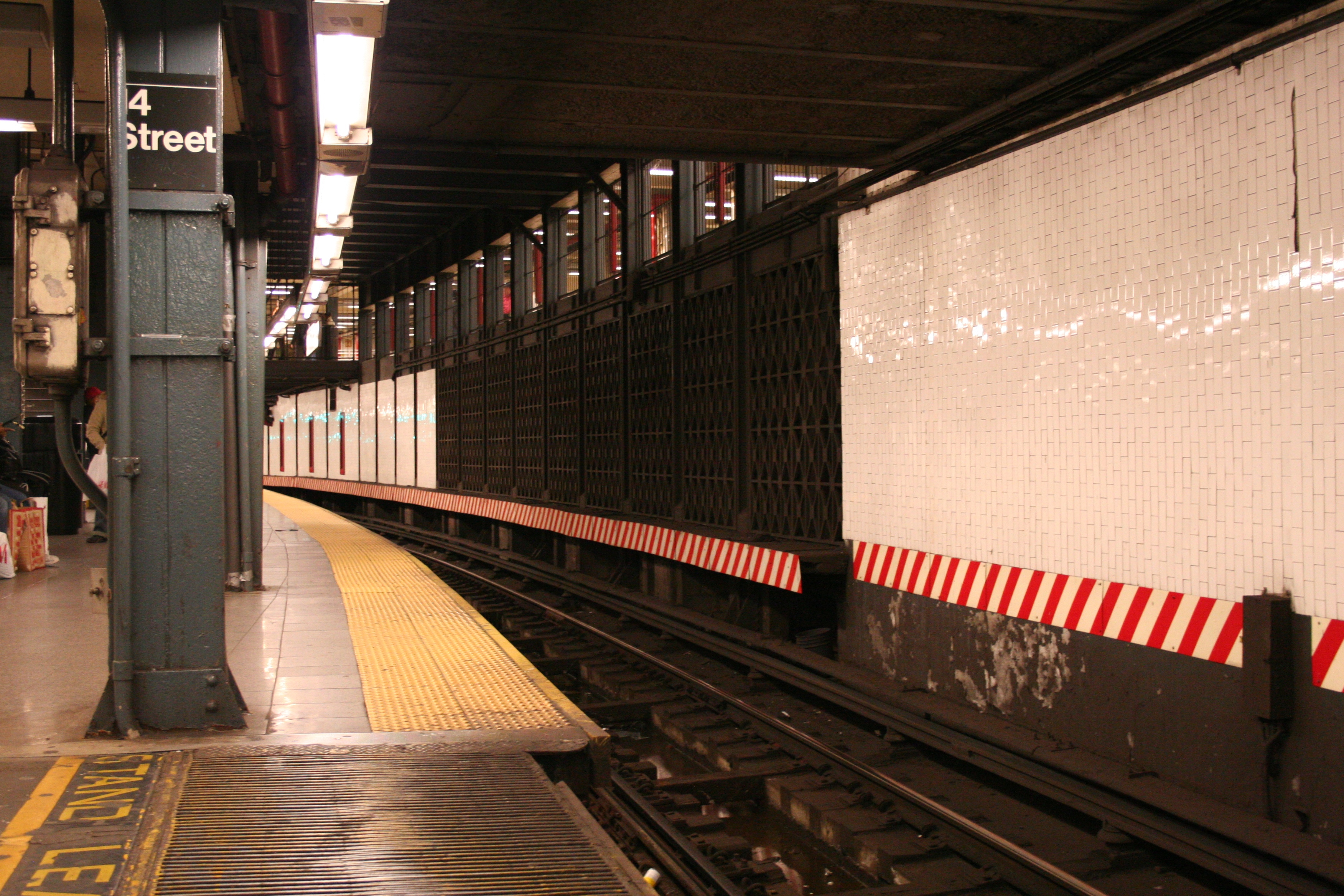
south_express_service = Lexington express14th Street–Union Square on the IRT Lexington Avenue Line has four tracks and two island platforms. The uptown and downtown platforms are offset from each other and slightly curved. Gap-filling movable platforms are automatically operated via proximity sensors mounted on the outside wall when trains arrive. The station has two abandoned local side platforms; the nouthbound one is visible through windows, bordered with wide, bright red frames. It looks like this platform is being used as a utility chase.Fact|date=February 2007 From the north end of the downtown platform's mezzanine one can see the abandoned southbound side platform through a hole in the plywood. The station's mezzanines are located over the platforms.
On
August 28 ,1991 , an accident occurred just north of the station, killing five people in one of the worst wrecks since theMalbone Street Disaster of 1918. The train operator, Robert Ray, had been overshooting platforms on the entire run. Just north of 14th Street–Union Square the train was to be shifted to the local track due to repairs. He had been running the train at 40 mph (65 km/h) in a 10 mph (16 km/h) zone and took the switch so fast that only the front of the first car made the crossover. The third and fourth cars ended up perpendicular to the tracks, having sheared off support columns and split in half. The line suffered heavy damage and service was disrupted for six days (trains terminating at 59th street for the duration) as transit workers toiled around the clock to clean up the wreckage. The entire infrastructure, including signals, switches, track, roadbed, cabling, and 23 support columns needed to be replaced. The motorman was sentenced to 15 years in prison, but was set free in April 2001 for good behavior.The wreck occurred between 18th Street station and 14th Street – Union Square on the downtown side at the entry to a former pocket track. Like 72nd Street on the
IRT Broadway–Seventh Avenue Line , 14th Street – Union Square was built with extra tracks on the approach to the station. These were between the incoming local and express track and were one old IRT train length long. The idea was to have a 'stacking' track where a train could be held momentarily until the platform cleared for it to enter the station. The tracks here and at 72nd Street were rendered useless when train lengths grew beyond their capacity. When the damage from the 1991 wreck was repaired, the stacking track was removed, but the crossover was not made gentler.BMT Broadway Line platforms
Infobox NYCS

bg_color = #FFC800
font_color = black
font_color_2 = black
line = BMT Broadway Line
service = Broadway
platforms = 2island platform s
tracks = 4
open_date =September 4 ,1917 New York Times , [http://www.nycsubway.org/articles/nytimes-1918-broadway.html Open New Subway to Times Square] ,January 6 ,1918 ]
north_line = BMT Broadway Line
north_local_station = 23rd Street
north_local_service = Broadway local
north_express_station = 34th Street–Herald Square
north_express_station_acc = yes
north_express_service = Broadway express
south_line=BMT Broadway Line
south_local_station=Eighth Street–NYU
south_local_service=Broadway local
south_express_station=Canal Street
south_express_service=Broadway express14th Street–Union Square on the BMT Broadway Line has four tracks and two island platforms. It is the southernmost station in
Manhattan with a cross-platform transfer between the Broadway services. A mosaic on the platform side walls is a depiction of "the junction of Broadway and the Bowery Road, 1828," as the area was once known. The mezzanine level has been reconstructed as well. Some former passageways and stairways have been closed off, including one immediately adjacent to the southernmost staircase on the northbound side. There are crossovers on the mezzanine to the NYCS|4, NYCS|5, NYCS|6, and NYCS|L lines for easy transfers.This station was overhaul in the late 1970s. MTA did fix the station's structure and the overhaul appearance. It replaces the original wall tiles, old signs, and incandescent lighting to the 70's modern look wall tile band and tablet mosaics, signs and fluorescent lights. It also fixed staircases and platform edges. In 2002, the station was receiving a major overhaul period. It was received state of repairs as well as upgrading the station for
ADA compliance and restoring the original late 1910s tiling. MTA did repair the staircases, re-tiling for the walls, new tiling on the floors, upgrading the station's lights and the public address system, installing ADA yellow safety threads along the platform edge, new signs, and new trackbeds in both directions. The station now has an elevator on both sides of the platform as well as connection to the station entrance and transferring to theIRT Lexington Avenue Line .In 2005, the artwork was installed here in the station, it is called "City Glow" by Chiho Aoshima.
BMT Canarsie Line platform
Infobox NYCS
bg_color = #838A88
line = BMT Canarsie Line
service = Canarsie
platforms = 1island platform
tracks = 2
open_date =September 21 ,1924
north_station = Sixth Avenue
north_line = BMT Canarsie Line
north_service = Canarsie
south_station = Third Avenue
south_line = BMT Canarsie Line
south_service = CanarsieUnion Square on the
BMT Canarsie Line has two tracks and one island platform, with numerous stairways and exits leading from it. There is one mezzanine attached to this station with entrances on the south side of 14th Street between Broadway and University Place. Other entrances around Union Square serve the other lines. The original mosaic band of sky blue, sea green, lime green and yellow ochre stands clearly visible above new green-bordered tile panels. The station has been renovated and is now ADA-compliant.Bus connections
* M1
* M2
* M3
* M6
* M7
* M9
* M14References
External links
* [http://www.nycsubway.org/ nycsubway.org]
** [http://www.nycsubway.org/perl/stations?5:3098 IRT East Side Line: 14th Street/Union Square]
** [http://www.nycsubway.org/perl/stations?202:3230 BMT Broadway Subway: 14th Street/Union Square]
** [http://www.nycsubway.org/perl/stations?203:2866 BMT Canarsie Line: Union Square]
* Station Reporter — [http://www.stationreporter.net/unionsq.htm 14th Street – Union Square Complex]
* Subway Map Station Details [http://www.onnyturf.com/wiki/index.php?page=14th+St-Union+Square 14th St-Union Square]
* [http://www.sawlady.com/blog/ Union Square subway musician tells what happens in the station] (blog)
Wikimedia Foundation. 2010.