- Fort Thomas, Kentucky
Infobox Settlement
official_name = Fort Thomas, Kentucky
other_name =
native_name =
nickname = Caketown
settlement_type =City
motto = "City of Beautiful Homes"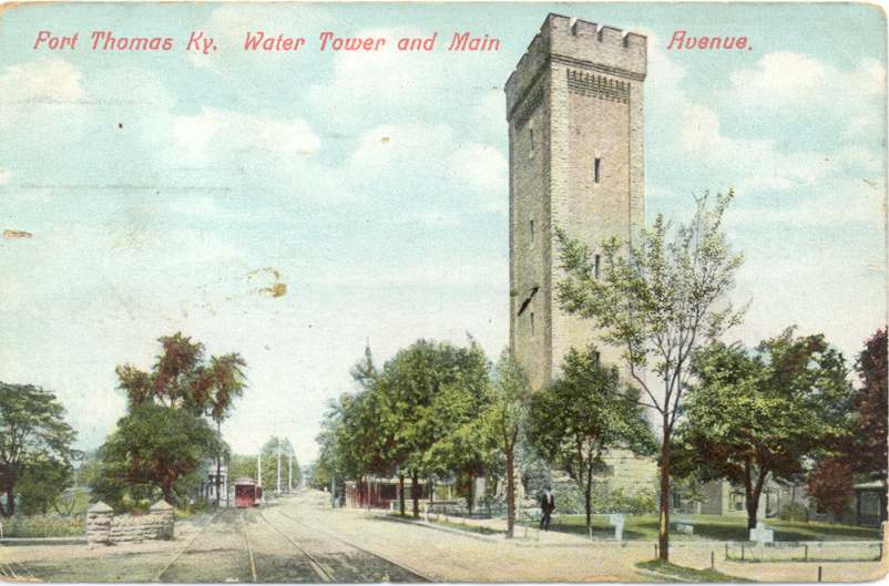
imagesize = 150px
image_caption = Postcard of the Fort in 1909
flag_size =
image_
seal_size =
image_shield =
shield_size =
image_blank_emblem =
blank_emblem_size =
mapsize = 250px
map_caption = Location of Fort Thomas, Kentucky
mapsize1 =
map_caption1 =
image_dot_
dot_mapsize =
dot_map_caption =
dot_x =
dot_y =
pushpin_
pushpin_label_position =
pushpin_map_caption =
pushpin_mapsize =
subdivision_type = Country
subdivision_name = flagicon|United StatesUnited States
subdivision_type1 = State
subdivision_name1 =Kentucky
subdivision_type2 = County
subdivision_name2 = Campbell
subdivision_type3 =
subdivision_name3 =
subdivision_type4 =
subdivision_name4 =
government_footnotes =
government_type =
leader_title = Mayor
leader_name = Mary H. Brown
leader_title1 = City Administrative Officer
leader_name1 =Don Martin
leader_title2 = City Treasure
leader_name2 = Fred W. Ewall
leader_title3 =
leader_name3 =
leader_title4 =
leader_name4 =
established_title = Settled
established_date = c. 1855
established_title2 = Incorporated
established_date2 = 1867
established_title3 =
established_date3 =
area_magnitude =
unit_pref = Imperial
area_footnotes =
area_total_km2 = 16.7
area_land_km2 = 14.7
area_water_km2 = 2
area_total_sq_mi = 5.7
area_land_sq_mi = 6.4
area_water_sq_mi = 5.7
area_water_percent = 0.7
area_urban_km2 =
area_urban_sq_mi =
area_metro_km2 =
area_metro_sq_mi =
population_as_of = 2000
population_footnotes =
population_note =
population_total = 16495
population_density_km2 = 1123.5
population_density_sq_mi = 2909.8
population_metro =
population_density_metro_km2 =
population_density_metro_sq_mi =
population_urban =
population_density_urban_km2 =
population_density_urban_sq_mi =
population_blank1_title =
population_blank1 =
population_density_blank1_km2 =
population_density_blank1_sq_mi =
timezone = EST
utc_offset = -5
timezone_DST = EDT
utc_offset_DST = -4
latd = 39 |latm = 4 |lats = 34 |latNS = N
longd = 84 |longm = 27 |longs = 5 |longEW = W
elevation_footnotes =
elevation_m = 262
elevation_ft = 860
postal_code_type = ZIP
postal_code = 41075
area_code = 859
blank_name = FIPS code
blank_info = 21-28594
blank1_name = GNIS feature ID
blank1_info = 0492357
website = http://www.ftthomas.org
footnotes =Fort Thomas is a city in Campbell County,
Kentucky , along theOhio River . The population was 16,495 at the 2000 census. The current mayor is Mary H. Brown. The city's official nickname is "The City of Beautiful Homes" and is known unofficially as "Cake Town". Downtown Fort Thomas has seen numerous updates in recent years.Geography
Fort Thomas is located at coor dms|39|4|34|N|84|27|5|W|city (39.076011, -84.451273).GR|1
According to the
United States Census Bureau , the city has a total area of 6.4 square miles (16.7 km²), of which, 5.7 square miles (14.7 km²) of it is land and 0.8 square miles (2.0 km²) of it (11.82%) is water.Climate
Fort Thomas is located within a climatic transition zone at the extreme northern limit of the
humid subtropical climate . The local climate is a basically a blend of the subtropics to the south and thehumid continental climate to the north. There are several "micro-climates" found in Fort Thomas which produce warmer than usual or cooler than usual "pockets". In the warmer niches it is not at all uncommon to find such "subtropical" novelties as the commonWall lizard , the Southern magnolia "(Magnolia grandiflora )", and even the rareNeedle palm ;Blue spruce andSalamander tend to occur in the cooler and shaded niches. Moderating variables for the overall climate of Fort Thomas include: the Ohio River, the region's relatively large hills and valleys, and an urban heat influence due to the proximity of the Cincinnati/Northern Kentucky (Covington, Newport, etc) metropolitan area. Fort Thomas is located within theBluegrass region of Kentucky and Southern Ohio and is also situated within the northern periphery of theUpland South .History
Evidence suggests that on or around 1749, prior to settlement by Europeans, a large battle occurred between a band of
Cherokee Native Americans and victoriousMiami tribe andShawnee tribe Native Americans in what is now the city of Fort Thomas. As many as 600 graves of slain warriors have been unearthed by archeologists there; although the battleground area has been thoroughly combed for artifacts and remains over the years, it is still not uncommon to find arrowheads and other artifacts from the past while gardening or hiking the woods and streambeds throughout the City.In 1887, a site was needed to house a
United States Army post to replaceNewport Barracks .Newport Barracks was located in the adjoining city ofNewport, Kentucky . Built in 1803, Newport Barracks replaced the smaller Fort Washington, which was located just across the river inCincinnati, Ohio . Post Newport was in Newport's lower westend at the point where the Licking River meets theOhio River . Prone to flooding, a higher location for a post was desired.The area has many remnants of this era with a convert|102|ft|m|sing=on high Stone Water Tower as a familiar landmark which stands at the entrance to Tower Park. It was the 16th structure built on the grounds of the Military Reservation. It encloses a standpipe which has a capacity of 100,000 gallons, pumped from the Water District reservoirs just across South Fort Thomas Avenue. In 1890 when the military base was established, such provisions for water supply was necessary as there was no other water tower in this area. Cannons that were captured in Cuba’s Havana Harbor during the Spanish-American War rest on stone platforms in front of the Tower. The dates marked on these cannons, reflecting the date they were made in Barcelona, Spain, are "1768" and "1769."
General
Philip Sheridan personally selected 11 acres of the city and dubbed the area the Highlands, predicting it to become the "West Point of the West." The new post was named Fort Thomas in honor of GeneralGeorge Henry Thomas .The U.S.
6th Infantry Regiment moved to Fort Thomas, where it remained until called to action again in June 1898, in theSpanish-American War .On February 25, 1937,
Paul Tibbets enlisted here as a flying cadet in theUnited States Army Air Corps . During the last days ofWorld War II , Paul became known as the pilot that dropped the firstAtomic Bomb on August 6, 1945.Information on the history is based primarily from the city's [http://www.ftthomas.org/History.html#anchor1154727 official website] .
chools
Fort Thomas has an independent public school district with 3 elementary schools (Robert D. Johnson Elementary, Ruth Moyer Elementary, and Samuel Woodfill Elementary), Highlands Middle School, and Highlands High School, which are consistently ranked among the top in the country. Highlands High School is the only public high school in the state with a Cum Laude chapter. [ [http://cumlaudesociety.org/members.html Cum Laude Membership ] ]
Highlands High School is ranked in the top 550 in the United States by "
US News & World Report ".The mascot for Highlands is the bluebird. According to local legend, in the early twentieth century the original mascot for the school was the Highlands Blue
Devil . A local clergyman objected to the association of the community to the devil. At the time, the boys' track team had an exceptionally good year and it was remarked that they "flew like birds." This gave rise to the new and current mascot.The Highlands football program is one of the most storied in all of Kentucky. Highlands has won 17 official state football championships and three "mythical" state titles prior to Kentucky instituting a statewide playoff system. The Bluebirds currently rank second in the state and fifth in the entire nation in total number of wins. More information about the football program is available at 'Birds Words, the football program's website (http://www.highlands-bluebirds.com). Current
New York Giants backup quarterbackJared Lorenzen starred in football at Highlands. He signed as a free-agent with the Giants after attending theUniversity of Kentucky .The school has twice won three consecutive girls' cross country championships in 1978-1980 and 2002-2004 and has won back to back girls' soccer championships (2005-2006).
The Highland's band has also received recognition. The marching band placed sixth in the
KMEA State semi-finals competition in 2005. In May 2007, the concert band received a distinguished rating, the highest, in the Kentucky State Concert Band Festival at the University of Louisville.There are two
Catholic private schools in the city, Saint Thomas Elementary and Saint Catherine Elementary.Cake Town
Custom has it that a large cake is prepared after state championship victory for the Highlands High School football team. This custom has lent itself to the people of Fort Thomas becoming known colloquially as Cake Eaters, and the city of Ft. Thomas as Cake Town. Though positive in origin, these terms are often used derogatorily by people outside of Ft. Thomas in the spirit of
Marie Antoinette 's legendary, "Let them eat cake," - alluding to the slightly higher per capita incomes of Ft. Thomas residents over the surrounding areas.Frequently Highlands High SchoolCheerleaders have a fight song that can be heard as "C-A-K-E -- C-A-K-E (clap clap)".Media
Fort Thomas is situated on the southern border of the Ohio River, directly opposite of
Cincinnati, Ohio . Therefore the major media market for the city is Cincinnati. Fort Thomas then uses Cincinnati's television and radio outlets.*Television:
**WLWT (NBC ), Channel 5
**WCPO (ABC), Channel 9
**WKRC (CBS ), Channel 12
**WXIX (FOX), Channel 19
**WCET (PBS), Channel 48
**WCVN (PBS), Channel 54 (Broadcast fromCovington, Kentucky ).
**WSTR (MyNetworkTV ), Channel 64
*Print Media:
**Daily Paper
***"The Kentucky Enquirer ", the Northern Kentucky edition of "The Cincinnati Enquirer ")
**Weekly Paper
***"The Fort Thomas Recorder", a special edition of "The Campbell County Recorder", delivered free to the city's residence but donation is suggested with the majority of the proceeds going to the delivery boy or girl.
** Monthly Paper
*** "Inside Fort Thomas", available free at newsstands and sent to every home in Fort Thomas.
**Magazine
***"Fort Thomas Living", a monthlymagazine sent through the mail as a free subscription to residents of Fort Thomas. FTL is also available at local newsstands.Churches
Several denominations are represented in the city. The following is a complete list of the city's churches:
*Christ Church,United Church of Christ
*First Baptist Church of Fort Thomas,Southern Baptist Convention
*First Christian Church,Christian Church (Disciples of Christ)
*First Presbyterian Church of Fort Thomas,Presbyterian Church (USA)
*Highland Avenue Baptist Tabernacle,Southern Baptist Convention
*Highland Hills Church,Southern Baptist Convention
*HighlandUnited Methodist Church
*Kingdom Hall ofJehovah's Witnesses
*Saint Andrew's Episcopal Church,Episcopal Church in the United States of America
*Saint Catherine of Siena Church,Roman Catholic
*Saint Paul's Church,United Church of Christ
*Saint Thomas' ChurchRoman Catholic
*The Next Chapter Church,Nondenominational Demographics
As of the
census GR|2 of 2000, there were 16,495 people, 6,742 households, and 4,335 families residing in the city. Thepopulation density was 2,909.8 people per square mile (1,123.2/km²). There were 7,028 housing units at an average density of 1,239.8/sq mi (478.6/km²). The racial makeup of the city was 97.61% White, 0.73% African American, 0.14% Native American, 0.66% Asian, 0.22% from other races, and 0.65% from two or more races. Hispanic or Latino of any race were 0.62% of the population.There were 6,742 households out of which 32.0% had children under the age of 18 living with them, 51.6% were married couples living together, 9.4% had a female householder with no husband present, and 35.7% were non-families. 31.1% of all households were made up of individuals and 11.7% had someone living alone who was 65 years of age or older. The average household size was 2.39 and the average family size was 3.04.
In the city the population was spread out with 25.0% under the age of 18, 7.8% from 18 to 24, 29.1% from 25 to 44, 22.3% from 45 to 64, and 15.8% who were 65 years of age or older. The median age was 38 years. For every 100 females there were 90.6 males. For every 100 females age 18 and over, there were 84.5 males.
The median income for a household in the city was $49,575, and the median income for a family was $63,006. Males had a median income of $43,733 versus $30,209 for females. The
per capita income for the city was $26,657. About 2.8% of families and 4.8% of the population were below thepoverty line , including 4.7% of those under age 18 and 3.2% of those age 65 or over.Notable Residents
*
Jim Bunning , Republican Senator who early in his political career served on the city council. He now lives in Southgate, KY.
*Cris Collinsworth , formerCincinnati Bengals wide receiver and national sports broadcaster
*Merril Hoge , formerPittsburgh Steelers running back and national sports broadcaster
*Jared Lorenzen ,New York Giants backup quarterback
*Sean Sester, current offensive lineman (right tackle) forPurdue Boilermakers football .Downtown
Fort Thomas has undergone numerous changes over the years. A recent push has renovated downtown Fort Thomas. Below is a picture of a branch of Citizens' Bank of Northern Kentucky at the corner of North Fort Thomas Ave and Miller Lane during the winter of 2006.
ee also
*
List of cities and towns along the Ohio River References
External links
* [http://www.nkyviews.com/campbell/campbell_main.htm Historical Images and Texts of Fort Thomas, Kentucky]
Wikimedia Foundation. 2010.